

Go with the flow
Face it, Manitoba -- the floods won't stop. We need to start dealing with them realistically
Advertisement
Read this article for free:
or
Already have an account? Log in here »
To continue reading, please subscribe:
Digital Subscription
One year of digital access for only $1.44 a week*
- Enjoy unlimited reading on winnipegfreepress.com
- Read the E-Edition, our digital replica newspaper
- Access News Break, our award-winning app
- Play interactive puzzles
*Billed as $5.77 plus GST every four weeks. After 52 weeks, price increases to the regular rate of $19.95 plus GST every four weeks. Offer available to new and qualified returning subscribers only. Cancel any time.
To continue reading, please subscribe:
Add Free Press access to your Brandon Sun subscription for only an additional
$1 for the first 4 weeks*
- Enjoy unlimited reading on winnipegfreepress.com
- Read the E-Edition, our digital replica newspaper
- Access News Break, our award-winning app
- Play interactive puzzles
*Your next Brandon Sun subscription payment will increase by $1.00 and you will be charged $17.95 plus GST for four weeks. After four weeks, your payment will increase to $24.95 plus GST every four weeks.
Read unlimited articles for free today:
or
Already have an account? Log in here »
Hey there, time traveller!
This article was published 31/03/2013 (4818 days ago), so information in it may no longer be current.
As every sentient being in southern Manitoba is well aware by now, there’s going to be another flood in the Red River Valley this year.
This deluge may be more severe than the Red River spring flood of 2011, when the Assiniboine River basin posed a bigger and more protracted problem. The 2013 flood should be more predictable than the 2009 edition, when ice jams wreaked havoc around Breezy Point and left officials in Winnipeg scrambling to deal with fluctuating river levels.
It will almost certainly will be nowhere near as frightening as the Flood of the Century in 1997, which displaced 30,000 Manitobans and came within a whisper of threatening Winnipeg with destruction.
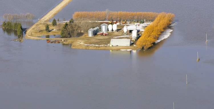
In fact, it’s tempting for Winnipeggers and people all over southern Manitoba to stop paying attention to Red River floods. When you include this spring and several summer floods, the Red will have exceeded its banks 15 times in the past 19 years.
There is a theory the frequency of these floods is a sign of climate change. This is somewhat common-sensical, given that long-term climate models call for increasing variability in for mid-continental areas such as the Canadian Prairies and U.S. Great Plains, a region where the weather is already highly variable from year to year and season to season.
The data, however, is not that conclusive. Climatologists and hydrologists are very careful creatures who are nowhere near ready to attribute the recent run of Red River floods to anthropogenic climate change.
But there’s no doubt human beings have altered the physical landscape of the entire Red River drainage basin, which includes tributaries such as the Assiniboine, Souris, Qu’Appelle, Red Lake, Pembina and Roseau rivers. People have been altering the way water flows across this vast drainage basin for more than 140 years, dating back to the first organized attempts to convert vast areas of wetlands into agricultural land.
Since the beginning of European settlement, Red River Valley residents have tried to define the place they live as “land.” Every schoolkid understands the basic concept: land is the place where people build homes and farms and factories. Water is where the boats and fish and mallards go.
But the reality is the Red River Valley can not accurately be described as either land or water. Historically, it’s a vast and highly variable wetland, prone to winding up under water some years and seasons and above the surface during others, depending on the whims of weather and the vagaries of human engineering.
Winnipeg-raised environmental historian Shannon Stunden Bower, the author of Wet Prairie, has helped popularize that term as a means of describing the Red River Valley, partly to distinguish where we live from the truly dry land that covers southern Saskatchewan and the vast majority of South Dakota.
But “wet prairie” is also useful for driving home the idea that the place where the vast majority of Manitobans reside is not actually land. We don’t live on terra firma, but on land we have attempted to define as dry, sometimes by simply declaring it so but more often by cutting a massive and largely ineffective network of drains across it.
The first European settlers who were enticed to live in southern Manitoba were promised farmland. Some wound up with land that was actually dry enough to farm.
Others found land that was wet during some years and dry during others. So they tried to drain it. And when they were successful, the farmers downstream complained the uplanders were artificially flooding them out.
In 1867, when Canada’s first four provinces entered Confederation, Ottawa assumed their debts. Manitoba, having no debt when it joined the Dominion in 1870, was offered up money for infrastructure instead. In a move that foreshadowed 143 years of futility, the young province asked for drainage money.
Thus began a long and often pointless program of cutting drains across the prairie in wet years, neglecting those same drains during dry years and then doing it all over again once all the soil had eroded off the higher elevations — degrading the agricultural land there — and clogging up the drains below.
By the latter part of the 20th Century, the size of the drains grew massive, as Manitoba started altering the hydrological landscape on a major scale. The Red River Floodway, Portage Diversion and Shellmouth Dam were all intended to spare the City of Winnipeg from the worst of Red River floods. The middling results — Winnipeg is safe at the cost of unpredictable flooding to the south and northwest — have only extended the unreliability of iron-age drainage technology to the scale of 21st-century industrial machinery.
Not only did we try to define seasonal wetlands as agricultural land, we carved up the resulting mess into a series of grid-shaped plots that had nothing to do with the actual landscape. Now, we’re living with the consequences of what Stunden Bower calls “chequer board squares in a dynamic landscape” — plots of private land and even entire municipalities where the borders have nothing to do with the way water actually moves across Manitoba.
Now, Manitobans living in both urban and rural areas have a profound sense of mistrust when it comes to any government-led effort to manage drainage. This is not the fault of the NDP, the Progressive Conservatives or the Liberal-Progressives before them.
It’s because it’s impossible for anyone to control the flow of water in a region where the climate was extremely variable even before human beings started sticking their shovels and backhoes and heavy machinery into the muddy soil.

No government effort to manage Manitoba — and yes, I mean the entire province — will succeed until the populace accepts the notion we live in a place that is and will always be wet, to some extent. Southern Manitoba needs to be viewed as just one part of the vast Red River basin watershed.
“This might be the most effective way to counter the negativity that developed as a consequence of what many have seen as the province’s failed drainage efforts,” writes Stunden Bower at the conclusion to Wet Prairie.
“In a landscape so variable, improved understanding of these local environmental realities might help to provide a more solid foundation for the future.”
Manitoba’s future depends on a realistic adaptation to the floods that will not stop. Whether they are in fact becoming more frequent is irrelevant, given our long and spectacular history of failing to deal with the water we already have.
bartley.kives@freepress.mb.ca
History
Updated on Sunday, March 31, 2013 8:52 AM CDT: corrects typo in confederation date
Updated on Monday, April 1, 2013 11:12 AM CDT: Corrects use of anthropogenic.