
Winnipeg, then and now
Read this article for free:
or
Already have an account? Log in here »
To continue reading, please subscribe:
Digital Subscription
One year of digital access for only $1.44 a week*
- Enjoy unlimited reading on winnipegfreepress.com
- Read the E-Edition, our digital replica newspaper
- Access News Break, our award-winning app
- Play interactive puzzles
*Billed as $5.77 plus GST every four weeks. After 52 weeks, price increases to the regular rate of $19.95 plus GST every four weeks. Offer available to new and qualified returning subscribers only. Cancel any time.
To continue reading, please subscribe:
Add Free Press access to your Brandon Sun subscription for only an additional
$1 for the first 4 weeks*
- Enjoy unlimited reading on winnipegfreepress.com
- Read the E-Edition, our digital replica newspaper
- Access News Break, our award-winning app
- Play interactive puzzles
*Your next Brandon Sun subscription payment will increase by $1.00 and you will be charged $17.95 plus GST for four weeks. After four weeks, your payment will increase to $24.95 plus GST every four weeks.
Read unlimited articles for free today:
or
Already have an account? Log in here »
Hey there, time traveller!
This article was published 24/03/2023 (1169 days ago), so information in it may no longer be current.
Winnipeg’s 150th anniversary is on the horizon.
Although Winnipeg was incorporated as a city on Nov. 8, 1873, its official sesquicentennial date is Jan. 19, 1874, the day the inaugural city council meeting was held.
As the anniversary approaches, the Free Press is digging into various archives to show how neighbourhoods and streetscapes have evolved over the last 150 years.
Visit this page over the coming months as we add new pictures.
Assiniboine Park footbridge
On a dollar-per-value basis, the $57,000 the City of Winnipeg spent in the 1930s to build a permanent footbridge to connect Portage Avenue and Assiniboine Park has paid for itself many times over.
The park opened in 1904 and was immediately popular. Initially, visitors accessing the park from the north first took a ferry to an island in the middle of the Assiniboine River, before embarking on a small floating bridge.
Starting in 1912, the city built and removed a pontoon bridge, as shown in the L.B. Foote photograph, each summer, at a cost of $1,400 annually.
According to the Winnipeg Architecture Foundation, the footbridge was erected partially as a Depression relief effort, much like the Norwood and Main Street bridges. The permanent structure, a 3.7-metre-wide concrete cantilever span, officially opened on May 31, 1932.


Dufferin Avenue and King Street
The photo below was taken at the corner of Dufferin Avenue and King Street, circa 1904, in the heart of New Jerusalem.
In 1916, 87 per cent of Winnipeg Jews resided in the North End, with the highest concentration north of the CPR line in an area bounded by Selkirk and Jarvis avenues and Main and Robinson streets.
According to the Jewish Heritage Centre of Western Canada, non-Jews referred to the area as New Jerusalem (or in even more pejorative terms), while Jews referred to it as Mitzraim, the Hebrew word for Egypt.


Osborne Street Lift Bridge
Motorists head north on the Osborne Street Lift Bridge, circa 1920. The bridge spanning the Assiniboine River stood from 1912 to 1976.
A gear from the old bridge is situated in the adjacent Gerald James Lynch Park. A plaque, unveiled in 1991 by then-mayor Bill Norrie, commemorates the longtime community activist from the River-Osborne area for whom the park was named.

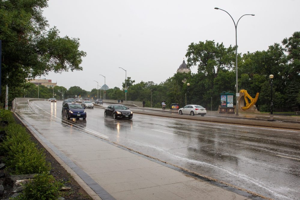
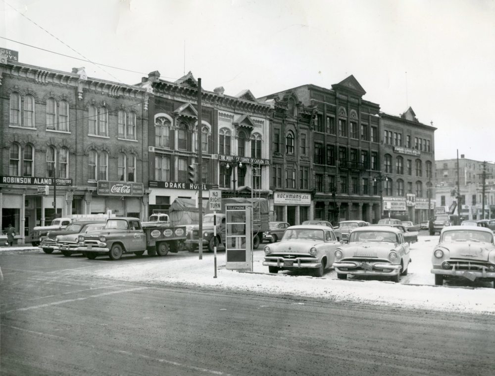
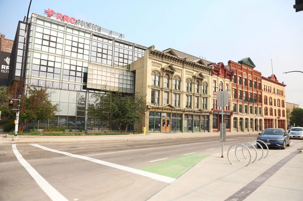
The Exchange District
The facades speak to Winnipeg’s past. Inside, instructors at Red River College Polytechnic prepare students for the future.
It was a melding of old and new when Red River opened its downtown campus in September 2002. The project preserved a pre-1900 streetscape that represented a time when architecture was booming in the early days of Winnipeg:
146 Princess St.: Formerly the Drake Hotel, built in 1882.
150 Princess: House of Comoy, Bawlf Block, also built in 1882. It’s a twin to the Drake Hotel and was primarily used as an office space.
154 Princess: The Hochman Building was a three-storey warehouse, built in 1882.
160 Princess: The Exchange Building was erected in 1898 and was the second home of the Winnipeg Grain and Produce Exchange.
164 Princess: The Utility Building was the first home for the exchange, built in 1892. Both its east- and north-facing facades were preserved.
Combined, the buildings represent one of the oldest business streetscapes in the Exchange District National Historic Site of Canada.
General Strike
For many, the image that captures the 1919 Winnipeg General Strike is the crowd surrounding the streetcar in the deadly Main Street clash with police.
That was the fiery conclusion, but the fuse was fanned six weeks earlier, two blocks to the east in a park that no longer exists. It was in Victoria Park, at the end of James Avenue near the river, where striking workers would gather in solidarity. The strike officially began on May 15, 1919. A day later, thousands descended upon the park to hear Rev. William Ivens, a member of the Central Strike Committee, editor of the Daily Strike Bulletin and founder of the Labour Church, urge the workers on in their fight.
The downtown park, with its close proximity to city hall, quickly became the strike’s rallying point, launching speeches, parades and marches and uniting thousands of voices into one.


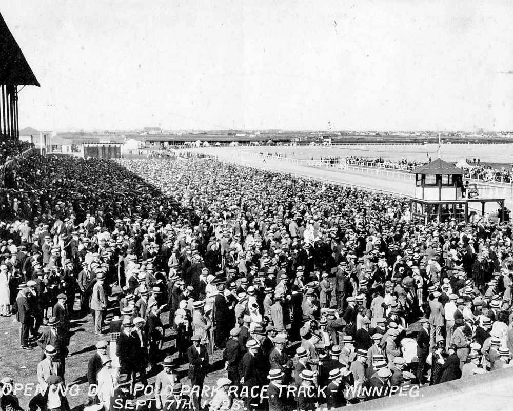
Polo Park
Its name is synonymous with shopping today, but for decades Polo Park stood for championship horse racing in the city.
Opening in the summer of 1925, the Polo Park Racetrack featured a six-furlong loop and grandstand seating for more than 3,000 spectators. The 60-acre site included six stables, with stalls accommodating nearly 300 horses, a clubhouse for the Manitoba Jockey Club and two toboggan slides.
It was the largest of three racetracks in the city at the time, costing approximately $150,000 to build. A special streetcar line on Portage Avenue serviced the track.
The ‘pretentious’ grandstand, as described in a Winnipeg Tribune article, burned down in 1937 in a spectacular blaze caused by faulty wiring.
As Winnipeg grew, so did the value of the racetrack’s land. It was sold in 1954, with the final races occurring two years later.
The origin of the name? It was for the polo field that was to be located in the racetrack’s infield.

Redwood and Main
It’s been an empty lot on the northeast corner of Redwood Avenue and Main Street for more than 20 years.
But go back more than a century, and it was the site of one of Western Canada’s better-known breweries, Drewy’s, and birthplace of one of Manitoba’s most iconic beers — Standard Lager.
The company was founded by Edward Lancaster Drewry four years after coming to Winnipeg in 1877 to take over the operation of the Redwood Brewery on the site.
Much like today, where there are more than two dozen breweries in operation in Winnipeg, the beer industry was thriving in the city’s early days.
Drewry retired in 1924 and sold the business to local investors, who operated the company as Drewry’s Limited.
Its most famous beer was Standard Lager, which was based on an 1877 recipe, and released in 1927 in celebration of the company’s 50th anniversary.
Its packaging long boasted it as a ‘lager of established quality, long favoured for its mellow, satisfying flavour.”
Drewry’s was bought in 1957 by Carling Brewery. Carling later merged with Molson, which closed the plant in 1997. It was demolished two years later.
Molson discontinued the Standard Lager line in 2022.


Emmanuel Lutheran Church
June 1919 remains one of the most turbulent months in Winnipeg’s history. The General Strike reached its apex on June 21 when two men were killed as crowds and police clashed on Main Street.
The temperature in the city wasn’t only rising metaphorically that June. Six days earlier, Winnipeg experienced the most powerful storm in its history as temperatures skyrocketed.
Hurricane-like winds reached 135 km/h, tearing off roofs from buildings, ripping up miles of telephone lines and blowing parked cars across streets like tumbleweeds. Remarkably, no one was seriously injured.
Early-Winnipeg photographer L.B. Foote captured some of the damage for the Free Press, including the cupola and steeple shorn off of Emmanuel Lutheran Church at the corner of College Avenue and McKenzie Street. The cupola and steeple were never replaced.
The building was converted into residential units in the 1980s.
The coverage of the storm paled in comparison to the General Strike. The arrests of labour leaders on June 16 and 17 set the stage for the violent Main Street clash — a day that has been immortalized as Bloody Saturday.
See front-page Free Press coverage of the storm from June 17, 1919.


600 block of Main Street
From a muddy ox-cart track that connected lower and upper Fort Garry to home to Winnipeg’s early hotels, banks and shops servicing the influx of immigrants at the turn of the 20th century, Main Street has been critical in the city’s economic development.
Today, it remains a vital transportation corridor and centre for community outreach. While many of the old buildings in the 600 block of Main Street still stand, their rich history has faded.
The Concordia Block, at 637 Main, was built in 1906 as a retail office and residential building. It was originally five storeys high, but the upper levels were torn down in the 1930s.
Mitchell Fabrics long called the building home. It was purchased by the Main Street Project after Mitchell Fabrics closed in 2017 and converted into a 36,000-sq.-ft. indoor shelter.
The hotel, at 655 Main, opened in 1889. It has gone through many iterations and names — Windsor, Maple Leaf, Roosevelt, National and now Manwin Hotel. It was shuttered for a period of time in 2021 for health violations, has been decried as uninhabitable for the vulnerable and was more recently the site of a homicide.
The Calder Building, at 661 Main, was built in 1912. It was the first electrically heated commercial building in Winnipeg. It currently houses Main Street Project’s food bank.
The Alloway and Champion Bank, at 667 Main, was built in 1905. Its Tyndall stone cladding was intended to represent confidence and security, two attributes the bank wanted to convey. The bank was privately owned by Henry Thompson Champion and William Forbes Alloway, with the latter the founder of the Winnipeg Foundation.
The Zimmerman Block, at 669 Main, was built in 1913. It is the architectural jewel on the block, with a decorative stone facade featuring garlands, carved women’s faces and lion heads. It has been the base for Lighthouse Missions for several decades, but the raised lettering on the cornice still boldly declares it as the “Zimmerman Bl.” Prior to Lighthouse, it was home to a jewelry store, diamond brokerage and various other retail tenants.
JAMES HAGGERTY / WINNIPEG FREE PRESS Main Street, March 1984
MIKE DEAL / WINNIPEG FREE PRESS
Connecting St. Boniface to Downtown
A bridge connecting St. Boniface and downtown has long been a vital part of Winnipeg’s infrastructure and fabric.
Ferries were replaced in 1882 when the first bridge spanning the Red River opened, connecting directly to Broadway Boulevard. A second bridge, which opened in 1918, angled traffic to the north toward Main Street. The current iteration follows a similar, yet curved, path.
The older photo is from the 1930s, looking west into Winnipeg’s downtown. The building in the background (centre) is the Federal Building, at 269 Main St., which was built in 1933. It still stands today.
At the turn of the century, there were two rail bridges that crossed into north St. Boniface. The one in the archival photo no longer exists.


The day Transcona grew up
The town of Transcona became a city in June 1961.
At the time, the community consisted of 14,000 residents and its main commercial strip, Regent Avenue, was six lanes wide, as the caption accompanying the below photo in the Winnipeg Free Press boasted.
The Royal George Hotel, which was built in 1913 and still stands today, remains an artifact from Transcona’s early days.
The community took root in the early 1900s when the Grand Trunk Pacific Railway identified a location east of Winnipeg for its western repair shop. Growth was rapid at first and, by 1916, Transcona was the second-largest town in Manitoba.
But it cooled off after several economic setbacks, including the town going bankrupt in 1921.
Transcona’s time as a city was short. It was amalgamated into Winnipeg, along with 11 other communities — including St. Boniface, St. Vital, East Kildonan, West Kildonan and St. James-Assiniboia — on Jan. 1, 1972, as part of Unicity.


Portage at Vaughan
For advertisers, the northeast corner of Portage Avenue and Vaughan Street — as the 1920 photo seems to suggest — was prime real estate.
From pianos to tobacco and from chocolates to coveralls, everything shoppers ever wanted was only a short walk away.
The building, at 431 Portage, was occupied by confectioner Mrs. Frank Lobdell, according to Manitoba Historical Society’s Gordon Goldsborough. She and her husband had two confectioneries, the other at 297 Notre Dame Ave.
Mr. Lobdell, secretary of the Retail Stores Association in the 1920s, had a colourful past. His name appears in court cases the previous decade for gambling, selling liquor and “allowing drunkenness at his apartment,” Goldsborough uncovered.
Today, the retail scene at the corner is far more muted. Portage Place, built in the 1980s and heralded as a saviour for a struggling downtown, is mostly vacant.
The shuttered Hudson Bay store, which would rise five years later from behind the photographer’s perspective, is awaiting a new future as envisioned by the Southern Chiefs’ Organization.
The only building still standing in the photo is the downtown branch of the YMCA, which opened in May 1913. It was designated a Winnipeg heritage site in 1985.


Monument not without modern-day controversy
The Volunteer Monument was unveiled amidst great fanfare in September 1886 on the grounds of the old Winnipeg City Hall.
Designed by architect Samuel Hooper, the sculpture of limestone and red granite was a tribute to the men of the 90th Winnipeg Battalion killed in the 1885 North West Rebellion, specifically at the Battle of Fish Creek on April 24, 1885, where battalion members acquired the nickname ‘Little Black Devils’, and the Battle of Batoche on May 12, 1885.
The sculpture was moved to its current location — across Main Street between the Manitoba Museum and Centennial Concert Hall — in the 1960s. It was also re-dedicated in 1963 to those who have served with the Royal Winnipeg Rifles.
The monument is not without modern-day controversy. When then-mayor Brian Bowman called for a policy to consider renaming historical markers in the city to address the absence of Indigenous perspectives, he cited the monument as an example because it fails to acknowledge the loss of Métis lives.


What is it about April 5?
If you are a Winnipegger or a Red River Valley resident of a certain vintage, you would know all too well the wrath of a snowstorm landing on that date.
It was April 5, 1997, when the region was hammered by an early spring storm that dumped a record 48 centimetres of snow, virtually shutting down the city for two days.
That snowfall, along with a wet fall the previous year, set the stage for the Flood of the Century.
The storm that arrived on April 5, 2023, didn’t pack the same punch, but rural schools closed, travel and weather advisories were issued, and residents were once again digging out.


Ah, springtime in Winnipeg
Potholes turn city streets into slalom courses, while garages are busy replacing shocks and struts for drivers whose vehicles were unable to avoid the road craters.
It’s been a seasonal rite of passage since paved roads replaced dirt ones in the city.
The caption accompanying the photo from April 4, 1956, could be reused with the photo taken earlier this week on Academy Road.
‘Potholes like this beauty on Corydon Avenue near Stafford Street are the plague of the Winnipeg’s city engineering department these days, which can offer no permanent solution for them until the streets dry out.
‘One crew is charged with filling up the worst potholes with a temporary mixture until permanent patches can be applied later on, and it was likely the above would receive this treatment…
‘The holes are caused in weather of the current Winnipeg variety when the daytime thaw sends water into the cracks and the night cold freezes it, causing it to expand and burst the pavement.’


Broadway and Main
A two-alarm fire swept through Fort Garry Court, a 74-year-old ‘housekeeping’ apartment building at Broadway and Main, Sunday, Feb. 1, 1976. (From our archives: read our coverage of the blaze: page 1, page 2)
Five men — William Tait, 60, Louis Desjarlais, 62, Elmore Gaul, 65, Andrew Lindstrom, 65 and James Black, 90 — died in the blaze while another 175 people were left homeless. (From our archives: read a feature on the investigation: page 1, page 2)
Following an inquest, a judge ruled the cause was arson and called for more stringent fire safety standards for buildings. (From our achives: read a story about the ruling.)
The Wawanesa Mutual Insurance Company building rose from the site’s ashes. The company was founded in 1896 in the southwestern Manitoba town of the company’s namesake. As the company grew and expanded into life insurance, it was decided to relocate the executive offices in Winnipeg in 1960.
When it came time to build its new headquarters in 1976, the location on Broadway was chosen because of the close proximity to other insurance institutions, making the street a financial hub.
According to the Winnipeg Architecture Foundation: “The nine-storey office building was designed by Vancouver architects Musson Cattell Mackey and Charles Bentall. In keeping with the earlier office buildings, the building is set back from the street and set on a low podium, slightly raised above sidewalk level. The pre-cast concrete panels have a light aggregate finish while the regular rectangular design of the facades take full advantage of pre-cast’s qualities. The darkly tinted windows protect the building’s interior from the southern sun and serve to emphasize the rectangular rhythm of the facade.”


Portage and Main
The underground concourse at Portage and Main opened in February 1979, but it would still be several months before all aboveground pedestrian traffic ceased.
The City of Winnipeg undertook a series of transport studies in the 1960s. It was during this time that it was decided pedestrians and vehicles could no longer co-exist in the intersection, according to the Winnipeg Architecture Foundation’s website.
The initial proposal for redirecting pedestrians through the intersection called for an above-ground disk — about 19 feet above street level and 225 feet across. The concept was scrapped because planners believed the disk would detract from new construction at the site.
The circular design was then incorporated into the below-ground construction project, which began in 1977. (Read a story about the construction from November 1977.)


Portage Avenue
On March 4, 1966, daily life in Winnipeg was brought to a halt by a monster blizzard.
Snow began falling just after midnight March 4. By morning, schools were closed, along with most stores and businesses. (See our front page and coverage from March 5.)
The city was battered by 80 km/h winds that gusted up to 109 km/h, and when it was all over, there was 35.5 centimetres of snow on the ground, an amount that would not be surpassed until 43.2 centimetres piled up in April 1997.


Related Articles
Winnipeg 150 celebration plans take shape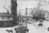
History
Updated on Friday, August 11, 2023 1:47 PM CDT: Updated with new photos.