

‘Significant’ flooding risk
South likely to be hit due to U.S. snow, province says
Advertisement
Read this article for free:
or
Already have an account? Log in here »
To continue reading, please subscribe:
Monthly Digital Subscription
$1 per week for 24 weeks*
- Enjoy unlimited reading on winnipegfreepress.com
- Read the E-Edition, our digital replica newspaper
- Access News Break, our award-winning app
- Play interactive puzzles
*Billed as $4.00 plus GST every four weeks. After 24 weeks, price increases to the regular rate of $19.00 plus GST every four weeks. Offer available to new and qualified returning subscribers only. Cancel any time.
Monthly Digital Subscription
$4.75/week*
- Enjoy unlimited reading on winnipegfreepress.com
- Read the E-Edition, our digital replica newspaper
- Access News Break, our award-winning app
- Play interactive puzzles
*Billed as $19 plus GST every four weeks. Cancel any time.
To continue reading, please subscribe:
Add Winnipeg Free Press access to your Brandon Sun subscription for only
$1 for the first 4 weeks*
*$1 will be added to your next bill. After your 4 weeks access is complete your rate will increase by $0.00 a X percent off the regular rate.
Read unlimited articles for free today:
or
Already have an account? Log in here »
Hey there, time traveller!
This article was published 23/02/2010 (5686 days ago), so information in it may no longer be current.
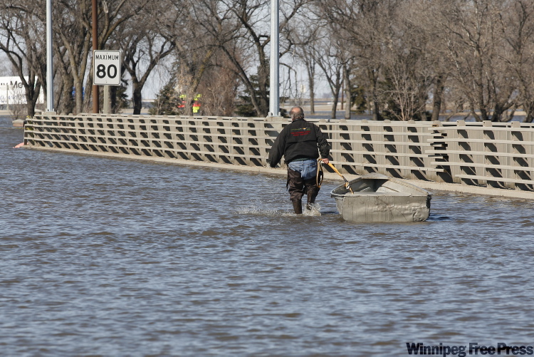
SOUTHERN Manitoba will likely see “significant” flooding this spring due to heavy snowfall south of the border and ground soil still soaked from last summer’s frequent rainstorms.
“I think at minimum we’re dealing with a hangover from 2009,” Emergency Measures Minister Steve Ashton said Monday at the province’s first spring flooding briefing for 2010. “We are clearly recognizing with this outlook that there is a significant risk for flooding.”
The high social moisture means melting snow has nowhere to go but the Red River, the province’s senior river forecaster Alf Warkentin said.
Warkentin said the anticipated water levels would be 0.3 to 0.9 metres (one to three feet) lower than last year, but that’s if Mother Nature co-operates and we don’t get more snow or rain.
With bad weather, conditions along the Red River could be about 0.3 metres (one foot) higher than in 2009, but still 0.3 to 0.6 metres (one to two feet) lower than in 1997.
The timing and speed of the spring breakup, and how much rain and snow we get in the next eight to 10 weeks, will have considerable effect on the flood potential.
“It’s very dependent on future weather,” Warkentin said. “This is still very early. We’re still in February. We still have 2months of weather in front of us.”
At this point, the run-off on the Red River in Manitoba is expected to be above average from Emerson to Morris but average from Morris through Winnipeg and into Lake Winnipeg. Run-off on the U.S. side of the border is expected to be well above average mostly because they’ve had more snow. Flooding in low-lying areas of the Interlake and along the Souris River watershed is also likely. Flooding is also expected on the Peguis River, but not as severe as last year.
The province advanced its spring flood preparations by about a month this year after last year’s flood caught many by surprise. Cold weather and thick river ice that refused to break up caused flood waters to rise rapidly, with the most damage caused north of Winnipeg where ice and water hit dozens of homes and cottages. Much of that damage won’t be repeated as the province has since bought out 60 low-lying properties in Breezy Point.
Total flood damage was about $40 million.
Steve Topping of Manitoba Water Stewardship said about 10 kilometres of river ice from Lake Winnipeg south towards the Selkirk Bridge have been cut so far. Next month, Amphibex icebreaking machines will smash it up in advance of rising flood water.
“We’re finding the ice is not as thick as it was last year, particularly north of Winnipeg,” Topping said.
Last year, 1,000 square kilometres of land were flooded in Manitoba. In 1997, the worst flood of the past 100 years, 1,700 square kilometres of land were flooded. If the weather stays favourable, it’s anticipated about 600 square kilometres of land will be flooded.
“We’re guaranteed of overland flooding,” but not enough to see communities evacuated, Ashton said.
Warkentin said while Fargo, N.D., has a 98 per cent chance of some significant flooding this spring, it doesn’t mean southern Manitoba and Winnipeg are in the same boat.
That’s because Winnipeg has its floodway and dike system, Warkentin said.
bruce.owen@freepress.mb.ca