

Berm on bottom of lake changes everything
Water flow divides at the Traverse Gap
Advertisement
Read this article for free:
or
Already have an account? Log in here »
To continue reading, please subscribe:
Digital Subscription
One year of digital access for only $1.44 a week*
- Enjoy unlimited reading on winnipegfreepress.com
- Read the E-Edition, our digital replica newspaper
- Access News Break, our award-winning app
- Play interactive puzzles
*Billed as $5.77 plus GST every four weeks. After 52 weeks, price increases to the regular rate of $19.95 plus GST every four weeks. Offer available to new and qualified returning subscribers only. Cancel any time.
To continue reading, please subscribe:
Add Free Press access to your Brandon Sun subscription for only an additional
$1 for the first 4 weeks*
- Enjoy unlimited reading on winnipegfreepress.com
- Read the E-Edition, our digital replica newspaper
- Access News Break, our award-winning app
- Play interactive puzzles
*Your next Brandon Sun subscription payment will increase by $1.00 and you will be charged $17.95 plus GST for four weeks. After four weeks, your payment will increase to $24.95 plus GST every four weeks.
Read unlimited articles for free today:
or
Already have an account? Log in here »
Hey there, time traveller!
This article was published 18/03/2011 (5560 days ago), so information in it may no longer be current.
LAKE TRAVERSE, S.D. – If Red River Valley residents ever need a scapegoat for the source of the spring floods that threaten their homes and livelihoods, they could blame a nondescript row of earth on the South Dakota-Minnesota border.
At the bottom of Lake Traverse sits a kilometre-long berm that marks the southern edge of the Red River drainage basin.
On the north side of the berm, which forms the continental divide, all the water drains north toward Hudson Bay. It leaves narrow Lake Traverse, enters an oversized puddle called Mud Lake, then meanders along the Bois de Sioux River until it joins with the Otter Tail River and officially becomes the Red River at Wahpeton, N.D.
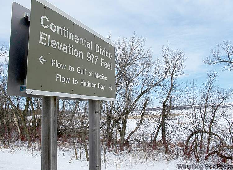
On the south side of the berm, water drains south toward the Gulf of Mexico, starting with the Little Minnesota River, which drains into Big Stone Lake, the Minnesota River proper and eventually the proverbially mighty Mississippi River.
On a weekday morning, motorists driving to and from Sisseton, S.D., and Browns Valley, Minn., cross over this divide, officially known as the Traverse Gap, at a rate of one every two or three minutes.
The highway — No. 10 in South Dakota and No. 28 in Minnesota — actually serves as the divide, which is marked by a highway sign on the South Dakota side as well as a wayside park that remains covered in snow in early March.
As recently as 8,400 years ago, there was no divide at all. Lake Agassiz, a massive pool of glacial meltwater that covered much of the Canadian Prairies and U.S. Great Plains, used to drain south through the Traverse Gap on its way to the Gulf of Mexico.
When the glaciers that once covered Manitoba retreated just enough, Lake Agassiz suddenly — and likely violently — drained in the opposite direction, toward the Arctic Ocean.
Geographers surmise enough fresh water spilled into Hudson Bay to cause worldwide ocean levels to rise metres in a space as short as several years.
Those events were probably witnessed by a handful of the estimated five million people who lived on the planet around 6400 BC.
Today, more than a million people live in the Red River Valley alone, with most of the population residing in the three largest metropolitan areas along the river: Winnipeg, Fargo and Grand Forks.
The term “valley” is, of course, a misnomer. The flood plain that contains the Red River is, in fact, a remnant lake bottom that extends up to 100 kilometres wide in southern Manitoba.
During Lake Agassiz’s final retreat, a person standing on the southwestern shore at the Manitoba Escarpment would not have been able to see across the horizon to the southeastern shore at modern-day Sandilands Provincial Forest.
The Red and its largest tributaries — the Assiniboine, Roseau, Pembina, Red Lake, Sheyenne, Otter Tail and Bois de Sioux among them — are recent additions to a post-glacial landscape that is itself one of the newest on Earth.
All these bodies of water have shifted courses hundreds of times since Lake Agassiz drained away, once you count every new channel cut by the river during the numerous floods of the past eight millennia.
Left to its own devices, the Red River would create islands out of peninsulas such as Kingston Crescent in Winnipeg, Oak Grove in Fargo or the Lincoln neighbourhood in Grand Forks, leaving oxbow lakes behind in the aftermath.

In geological terms, prairie rivers are always changing. People build homes along the edge and expect a degree of permanence to a waterfront that is, in fact, dynamic.
All three cities have responded differently to the quirk of settlement on a flood plain. In Grand Forks, almost all of Lincoln was appropriated, flattened and placed behind new flood walls after 1997. In Fargo, parts of Oak Grove were bought up and demolished after 2009.
Winnipeg protects Kingston Row with sandbags and the Red River Floodway. But a day may come when protection against a one-in-500-years flood isn’t enough.
The entire Red River Valley was once a lake and still behaves like one when the river that begins at a place where a row of dirt meets a highway decides it doesn’t feel like being a river any more.
bartley.kives@freepress.mb.ca
History
Updated on Saturday, March 19, 2011 12:48 PM CDT: Sandilands is a provincial forest.