

Alarm raised in ND over high risk of Red River flooding
Advertisement
Read this article for free:
or
Already have an account? Log in here »
To continue reading, please subscribe:
Monthly Digital Subscription
$0 for the first 4 weeks*
- Enjoy unlimited reading on winnipegfreepress.com
- Read the E-Edition, our digital replica newspaper
- Access News Break, our award-winning app
- Play interactive puzzles
*No charge for 4 weeks then price increases to the regular rate of $19.00 plus GST every four weeks. Offer available to new and qualified returning subscribers only. Cancel any time.
Monthly Digital Subscription
$4.75/week*
- Enjoy unlimited reading on winnipegfreepress.com
- Read the E-Edition, our digital replica newspaper
- Access News Break, our award-winning app
- Play interactive puzzles
*Billed as $19 plus GST every four weeks. Cancel any time.
To continue reading, please subscribe:
Add Free Press access to your Brandon Sun subscription for only an additional
$1 for the first 4 weeks*
*Your next subscription payment will increase by $1.00 and you will be charged $16.99 plus GST for four weeks. After four weeks, your payment will increase to $23.99 plus GST every four weeks.
Read unlimited articles for free today:
or
Already have an account? Log in here »
Hey there, time traveller!
This article was published 22/02/2017 (3226 days ago), so information in it may no longer be current.
The U.S. National Weather Service says there is more than an 80 per cent chance of major flooding along the Red River near the Manitoba border in the coming months.
The projection is based on 60 years of weather data.
“Our outlook has moderate-to-major flooding through the northern part of the Red River Valley, from basically Grand Forks north to Pembina (just south of the Manitoba border),” said Greg Gust, warning co-ordination meteorologist with the NWS in Grand Forks.
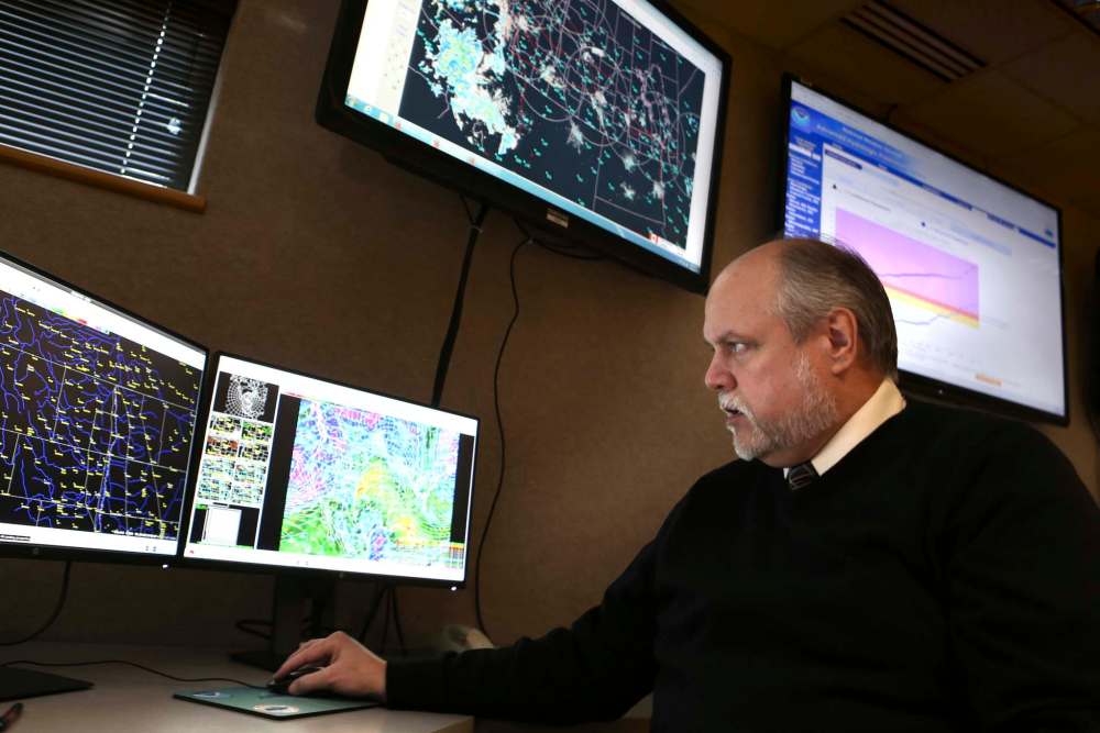
But the flood risk rises as the river flows northward, Gust said on Wednesday.
U.S. officials regard the threshold for a major flood at Pembina to be 49 feet. They estimate there’s an 83 per cent chance of that occurring.
“At that point, that’s where it’s beginning to impact some of the roadways…” Gust said, although not Interstate 29, which begins at the border.
However, there’s a 50 per cent chance of waters reaching 51.5 feet at Pembina — a level comparable to the 2006 and 1996 Red River floods. At that point, the U.S. border town would likely take measures to seal the dike that protects it.
And there’s a 25 per cent chance of waters climbing to 52.6 feet at Pembina, which is closer to levels reached in 2009 — one of the largest floods in recent times on both sides of the border.
Unseasonably mild temperatures in recent days have accelerated the spring melt in parts of North Dakota. The Red River in Fargo is expected to crest at 21.7 feet on Friday. A level of 18 feet is considered minor flood stage, in which the very lowest portions of the river bank are breached. At 22 feet, one of the city’s bridges is closed.
In Grand Forks, a minor crest of 31 feet is expected Saturday afternoon, although residents in that city are far from threatened. Several years ago, Grand Forks built protection to withstand a flood of 60 feet.
Most fields in the Fargo area are bare after a recent run of mild temperatures that hit double digits Celsius there this past weekend. There is still some snow cover from Grand Forks to the Canadian border.
While the unusually early melt cleared fields in the southern part of the Red River Valley, the resumption of normal temperatures this week will slow the movement from ditches and tributaries to the Red itself, Gust said.
“We could hit the minor flood stage toward Pembina sometime at the week’s end or early next week. But that water’s going to stall,” he said.
The major crest will come later when melting resumes in earnest — perhaps exacerbated by more precipitation.
“We’re going to see water move up there (towards Pembina and Manitoba) and raise the (river) ice. And then we’re going to have to wait now for the whole rest of the melt process. It could be the end of March, it could be the middle of April before that finishes up,” Gust said.
Manitoba will issue its first formal flood forecast on Monday.
In a media briefing late last month, provincial officials said several rivers, including the Red and lower Assiniboine, were at risk of major flooding if unfavourable weather conditions persisted.
High soil moisture levels before freeze-up and above-normal snowfall so far this winter had created the potential for modest to major overland flooding in most areas of the province, the government said.
Snowfall amounts in the Red River basin in the United States and the Winnipeg River basin in Ontario were also above normal, officials said.
Manitoba flood forecasters are likely to point out — as Gust did Wednesday — that there are still a lot of variables to take into account in predicting the size of this year’s flood, including the timing and amount of future precipitation and the rapidity of the future melts.
“It’s still February so we expect there’s still going to be some winter left to go, and we expect it will throw a couple of more layers of interesting on top of what we have now,” Gust said.
Meanwhile, the province announced Wednesday it has begun its annual ice-breaking operations on more than 25 kilometres of Red River ice north of Selkirk. The work is done to prevent ice jams during the spring melt.
Darrell Kupchik, director of operations, North Red Waterway Maintenance Inc., said ice-cutters are beginning their work at about the same time as they did last year.

“When our mission here is completed (in) mid-March, we would expect to have anywhere from 27 to 28 kilometres of broken ice,” he said Wednesday.
The river ice is from 60 cm to 75 cm deep, Kupchik said.
Provincial officials warn ice fishers and snowmobilers to observe warning signs and stay clear of ice-cutting equipment. Safety notices have been posted in areas where the ice-breaking machines will be working.
larry.kusch@freepress.mb.ca

Advertisement Advertise With Us
Advertisement Advertise With Us