

Probable tornado reported in Killarney Tuesday

Advertisement
Read this article for free:
or
Already have an account? Log in here »
To continue reading, please subscribe:

Digital Subscription
One year of digital access for only $205*
- Enjoy unlimited reading on winnipegfreepress.com
- Read the E-Edition, our digital replica newspaper
- Access News Break, our award-winning app
- Play interactive puzzles
*First annual payment billed as $205.00 + GST for one year. This annual subscription will automatically renew at $233.00 + GST every 52 weeks (10% off the regular annual price of $259.35). Offer available to new and qualified returning subscribers only. Cancel any time.
To continue reading, please subscribe:
Add Free Press access to your Brandon Sun subscription for only an additional
$1 for the first 4 weeks*
- Enjoy unlimited reading on winnipegfreepress.com
- Read the E-Edition, our digital replica newspaper
- Access News Break, our award-winning app
- Play interactive puzzles
*Your next Brandon Sun subscription payment will increase by $1.00 and you will be charged $17.95 plus GST for four weeks. After four weeks, your payment will increase to $24.95 plus GST every four weeks.
Read unlimited articles for free today:
or
Already have an account? Log in here »
Hey there, time traveller!
This article was published 21/06/2023 (1119 days ago), so information in it may no longer be current.
Investigators are headed to the Killarney area after a probable tornado and golf ball-sized hail hit Tuesday night, damaging buildings and trees.
“I think everybody’s aware of how intense the storms were in southern Manitoba last night. We’ve spent time tracking those storms,” said David Sills, executive director of the Northern Tornadoes Project at Western University in London, Ont.
Sills said the storm cannot be classified a tornado until the team, which will include researches from the University of Manitoba, documents radar-detected tornado debris and resident-reported damage at three locations southwest and north of Killarney, located 240 kilometres southwest of Winnipeg.

Photo by Stephanie Kroeker
Storage silos damaged by storm on Tuesday, north of Killarney, MB, about 250 kms southwest of Winnipeg.
Evidence includes social media accounts of a tornado sighting, golf-ball-sized hail and flooding, as well as damage to structures, grain bins and trees.
Some of the reported damage includes a row of battered grain bins, all caved in along a straight line on Kroeker Acres, a family farm near Killarney that grows potatoes and organic crops.
Stephanie Kroeker captured a striking photo of the damaged bins Wednesday morning, saying she believes the damage was caused by a plow wind, which are strong, straight-across winds typically brought on by a thunderstorm, compared with the long, narrow, track-type damage a tornado can leave in its wake. Both of those types of winds can happen at the same time.
“Sometimes it’s both. Takes a lot of careful investigation to gather all those clues up and do the analysis so we know exactly how to classify these events and how to rate them using the EF (Enhanced Fujita) scale,” Sills said.
Environment and Climate Change Canada, which tracked the storm remotely, said it moved into Manitoba from North Dakota.
No injuries had been reported in Tuesday’s storm, said Environment Canada meteorologist Natalie Hasell.
Radar picked up a signature-4 rotation, “so it’s quite possible that we had a tornado in that area,” Hasell said. But they’re waiting on damage reports to confirm, and don’t have any confirmed sightings of the tornado. It would’ve been difficult to see because it was near sunset and the sky was overcast with dark clouds.
The federal agency didn’t issue a separate tornado warning before the storm hit the area between 9:30 p.m. and 9:45 p.m. Tuesday, but Environment Canada did put out multiple severe thunderstorm watches and warnings that mentioned the possibility of a tornado, Hasell said.
“Our greater concern was actually the hail,” she said.
“The messaging, I think, focused on the things that were particularly important.”
Toonie- to golf ball-sized hail was reported at Peguis First Nation, while loonie- and toonie-sized hail was reported in Hodgson, Eriksdale and Little Grand Rapids. Some places in the Interlake got heavy rain and flooding, including between the north and south basins of Lake Winnipeg, said Hasell.
The first severe thunderstorm watch notice, which included Killarney-Turtle Mountain and mentioned the risk of a tornado, was published just before 3:30 p.m. Tuesday. The agency stated it was tracking a storm capable of producing softball-sized hail and wind gusts more than 110 km/hr.

Radar for the Northern Tornadoes Project picked up “tornado debris,” Sills said.
The project has been running since 2017 and tracking tornadoes across Canada since 2019, in hopes of gathering high-quality data. Figuring out trends in thunderstorms and tornado occurrences is a lot more complicated than large-scale events such as wildfires, droughts or even hurricanes that can be more easily attributed to the changing climate, Sills said.
“It’s very regional, and we have to collect meaningful data in order to be able to pull out all those trends, and even if we find a trend, connecting it to climate change is yet another step in the process. This is work that we’re undertaking, but we’re really just beginning.”
Residents and property owners can report storm damage to Environment and Climate Change Canada using the hashtag #mbstorm on Twitter, by email at storm@ec.gc.ca or by calling the public severe weather reporting line: 1-800-239-0484.
katie.may@freepress.mb.ca
Katie May is a multimedia producer for the Free Press.
Our newsroom depends on a growing audience of readers to power our journalism. If you are not a paid reader, please consider becoming a subscriber.
Our newsroom depends on its audience of readers to power our journalism. Thank you for your support.
Related Articles
Three tornadoes from storm confirmed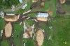
Advertisement Advertise With Us
Advertisement Advertise With Us