

Possible tornado in southeast Manitoba; hail strikes multiple areas

Advertisement
Read this article for free:
or
Already have an account? Log in here »
To continue reading, please subscribe:
Digital Subscription
One year of digital access for only $1.44 a week*
- Enjoy unlimited reading on winnipegfreepress.com
- Read the E-Edition, our digital replica newspaper
- Access News Break, our award-winning app
- Play interactive puzzles
*Billed as $5.77 plus GST every four weeks. After 52 weeks, price increases to the regular rate of $19.95 plus GST every four weeks. Offer available to new and qualified returning subscribers only. Cancel any time.
To continue reading, please subscribe:
Add Free Press access to your Brandon Sun subscription for only an additional
$1 for the first 4 weeks*
- Enjoy unlimited reading on winnipegfreepress.com
- Read the E-Edition, our digital replica newspaper
- Access News Break, our award-winning app
- Play interactive puzzles
*Your next Brandon Sun subscription payment will increase by $1.00 and you will be charged $17.95 plus GST for four weeks. After four weeks, your payment will increase to $24.95 plus GST every four weeks.
Read unlimited articles for free today:
or
Already have an account? Log in here »
Hey there, time traveller!
This article was published 27/07/2023 (1178 days ago), so information in it may no longer be current.
Meteorologists are investigating whether the severe weather that rocked the Beausejour area and other parts of Manitoba’s southeast Wednesday included a tornado.
Environment and Climate Change Canada officials said, as of Thursday evening, there had not been confirmation of a tornado in the area. However, some 180 kilometres to the north, a tornado was confirmed to have touched down at 6:05 p.m. at Beaver Creek Provincial Park.
The federal weather agency had received “many reports” of funnel clouds and wind damage around Beausejour, warning preparedness meteorologist Natalie Hasell said.
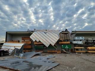
McMunn and Yates store in Beasejour. (Facebook)
“The storm in Beausejour could easily have had a tornado, but we’re still investigating. Strong winds can come from tornadoes or it can come from the down-burst section of the storm, which is the precipitation area of the storm, and they can interact — they can happen at the same time, often,” Hasell said Thursday morning.
“It can take a while to detangle what really happened, but we are working on it.”
Whether or not a tornado occurred, area residents testified the weather they experienced was harrowing.
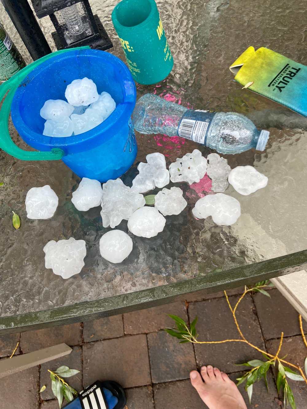
“I’ve never seen hail that bad my entire life,” said Matt Sunstrum of St. Andrews, some 35 km west of Beausejour. “It looked like… little cannonballs, just battering everything.”
Sunstrum and his family were using their pool, when they noticed the clouds darkening and the sound of thunder at around 5 p.m. They took cover inside their home, and later retreated to the basement after a tornado warning via their cellphones.
Loud banging sounds outside brought him up for a look.
“My wife heard a whacking sound, something hitting the side of the house,” Sunstrum said. “We were like, ‘What the heck is that?’”
Fortunately, Sunstrum said, his property, protected by many willow trees, escaped extensive damage, beyond dented vehicles.
Not far away, Beausejour Mayor Ray Schirle said the damage in town of some 2,900 people was extensive and unprecedented in his five-year tenure.
Schirle and some councillors were meeting with fire department officials at town hall when the storm hit. The Beausejour Brokenhead Fire Department was immediately inundated with calls.
“The fire department did a wonderful job,” Schirle said. “They actually got their first call when we were in our meeting.”
Power lines were downed and buildings damaged, primarily in the southeastern part of the town, the mayor said. A seniors home lost power until midnight.
Insurance company reps will be in town Friday to assess the damage. Based on preliminary numbers the Town of Beausejour has received from contractors, it is expected repair costs will be in the millions, the mayor said.
Two families had to move out of their respective homes after the storm destroyed their roofs. Schirle said there is still the “odd house” without power.
Most local businesses were able to operate Thursday, but the local racetrack was completely destroyed, the mayor said.
Hasell said there were also reported funnel clouds in the Selkirk and Stony Mountain areas.
The federal weather agency put out an emergency alert at 6:24 p.m. Wednesday, issuing a tornado warning for the area and advising people to take immediate cover if “threatening weather approached.”
Multiple supercell thunderstorms tracked east through Manitoba’s southeast from the afternoon through the evening, Environment Canada said in a weather summary released late Wednesday night.
Hasell said two main supercells caused “quite a bit of havoc” amongst the other storms.
“One developed in the Interlake, just west of Fisher River Cree Nation, ahead of a surface warm front. The second, near the Winnipeg north Perimeter (Highway), which developed along a surface dry line,” the weather agency’s summary said.
There were also reports of large hail across the southeast, including about 10 centimetres at Fisher Bay and Fisher River.
East Selkirk and Falcon Lake got baseball-sized hail, Lockport got hail the size of a tennis ball, St. Andrews and Selkirk the size of an egg, and Tyndall was hit with golf ball-sized hail, Environment Canada said.
The Northern Tornadoes Project, an academic research group that studies tornadoes throughout Canada, said in a social media post its University of Manitoba storm survey team will be investigating damage in the province’s southeast. (It asked area residents to send damage reports or information on potential tornadoes in the region to ntp@uwo.ca.)
Environment Canada staff will further investigate radar signatures and satellite imagery before and after the storms to try to determine how the weather interacted, Hasell said. (The agency has asked anyone with information, including pictures of potential tornadoes, to call 1-800-239-0484 or email storm@ec.gc.ca.)

Hasell noted tornadoes are rated via damage, which then gives the agency estimated wind speeds.
“It’s important to remember the… scale that we use is a damage scale. In this case, some buildings did get hit, did get wind damage, so we can actually rate something,” she said.
“If the same storm went through a field, where there would be no buildings, we wouldn’t be able to rate it.”
erik.pindera@freepress.mb.ca
graham.mcdonald@freepress.mb.ca
Erik Pindera is a reporter for the Free Press, mostly focusing on crime and justice. The born-and-bred Winnipegger attended Red River College Polytechnic, wrote for the community newspaper in Kenora, Ont. and reported on television and radio in Winnipeg before joining the Free Press in 2020. Read more about Erik.
Every piece of reporting Erik produces is reviewed by an editing team before it is posted online or published in print — part of the Free Press‘s tradition, since 1872, of producing reliable independent journalism. Read more about Free Press’s history and mandate, and learn how our newsroom operates.
Our newsroom depends on a growing audience of readers to power our journalism. If you are not a paid reader, please consider becoming a subscriber.
Our newsroom depends on its audience of readers to power our journalism. Thank you for your support.
Erik Pindera is a reporter for the Free Press, mostly focusing on crime and justice. The born-and-bred Winnipegger attended Red River College Polytechnic, wrote for the community newspaper in Kenora, Ont. and reported on television and radio in Winnipeg before joining the Free Press in 2020. Read more about Erik.
Every piece of reporting Erik produces is reviewed by an editing team before it is posted online or published in print — part of the Free Press‘s tradition, since 1872, of producing reliable independent journalism. Read more about Free Press’s history and mandate, and learn how our newsroom operates.
Our newsroom depends on a growing audience of readers to power our journalism. If you are not a paid reader, please consider becoming a subscriber.
Our newsroom depends on its audience of readers to power our journalism. Thank you for your support.
Advertisement Advertise With Us
Advertisement Advertise With Us
History
Updated on Thursday, July 27, 2023 6:16 PM CDT: Revised copy
Updated on Thursday, July 27, 2023 10:40 PM CDT: Photo added