The US East Coast is under a tropical storm warning with landfall forecast in North Carolina

Advertisement

Advertise with us

MIAMI (AP) — A storm moving closer to the U.S. East Coast will deliver tropical storm conditions to North Carolina on Friday before making landfall on Saturday, the National Hurricane Center said.

Read this article for free:


or

Already have an account? Log in here »

To continue reading, please subscribe:

Subscribe and receive a limited-edition Free Press branded hat or tote.

Digital Subscription

One year of digital access for only $205*

  • Enjoy unlimited reading on winnipegfreepress.com
  • Read the E-Edition, our digital replica newspaper
  • Access News Break, our award-winning app
  • Play interactive puzzles

*First annual payment billed as $205.00 + GST for one year. This annual subscription will automatically renew at $233.00 + GST every 52 weeks (10% off the regular annual price of $259.35). Offer available to new and qualified returning subscribers only. Cancel any time.

To continue reading, please subscribe:

Add Free Press access to your Brandon Sun subscription for only an additional

$1 for the first 4 weeks*

  • Enjoy unlimited reading on winnipegfreepress.com
  • Read the E-Edition, our digital replica newspaper
  • Access News Break, our award-winning app
  • Play interactive puzzles
Start now

*Your next Brandon Sun subscription payment will increase by $1.00 and you will be charged $17.95 plus GST for four weeks. After four weeks, your payment will increase to $24.95 plus GST every four weeks.

Hey there, time traveller!
This article was published 21/09/2023 (1116 days ago), so information in it may no longer be current.

MIAMI (AP) — A storm moving closer to the U.S. East Coast will deliver tropical storm conditions to North Carolina on Friday before making landfall on Saturday, the National Hurricane Center said.

The storm was off the coast of South Carolina and North Carolina with top sustained winds of 50 mph (85 kph). A storm surge watch was in effect, with surges between 3 and 5 feet (0.9 to 1.5 meters) forecast for parts of North Carolina, the center reported.

As of Friday morning, the storm was located about 330 miles (530 kilometers) southeast of Charleston, South Carolina, and about 325 miles (525 kilometers) south Cape Hatteras, North Carolina, and moving north around 14 mph (22 kph), the center said.
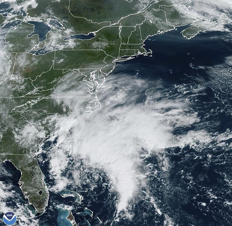
This Thursday, Sept. 21, 2023, satellite image provided by the National Oceanic and Atmospheric Administration shows a potential tropical cyclone forming off the southeastern coast of the United States in the Atlantic Ocean. (NOAA via AP)

Rainfall of 3 to 5 inches (7.6 to 12.7 centimeters), with localized amounts up to 7 inches (17.7 centimeters), was expected across eastern North Carolina and into southeast Virginia through Saturday, the center said.

Though the system had reached tropical storm strength, it was yet to be given a name and the center was still referring to it as Potential Tropical Cyclone Sixteen on Friday morning. The hurricane center defines a potential tropical cyclone as a disturbance posing a threat of tropical storm or hurricane conditions to land within 48 hours.

Meteorologist Maria Torres, a public affairs officer with the Miami-based center, said people along the Atlantic coast need to watch the storm’s progress, gather supplies and make preparations for its arrival.

“This will bring some tropical storm force winds and storm surge along with the high winds to the East Coast through the weekend, mainly from the Southeast to the Mid-Atlantic states,” she told The Associated Press.

The tropical storm warning was in effect from Cape Fear, North Carolina, to Fenwick Island, Delaware. It also includes the Chesapeake Bay south of North Beach, Tidal Potomac south of Cobb Island and Albemarle and Pamlico Sounds. Storm surge warnings were in effect for areas throughout the region, the hurricane center said.

Virginia emergency management officials warned of heavy rain, high winds and flooding in the next few days.

The Virginia Department of Emergency Management said on social media Thursday that officials are coordinating with local weather service offices to watch the system developing off the coast. Officials called on residents to prepare for the storm and impacts on the region throughout the weekend.

North Carolina Emergency Management warned large swells from distant Hurricane Nigel also would reach the state’s coast on Thursday, boosting the rip current risk. The combination of those swells and the low-pressure system could mean additional ocean overwash, beach erosion and coastal flooding.

The hurricane center said storm surge between 2 and 4 feet (0.6 to 1.2 meters) was expected.

A storm surge warning was in effect from Duck, North Carolina, to Chincoteague Virginia, including Chesapeake Bay south of Windmill Point, and for the Neuse River, the Pamlico River, and portions of Pamlico Sound.

A storm surge watch also was issued from Surf City in North Carolina to Duck, North Carolina, along with Chesapeake Bay north of Windmill Point to Smith Point, the Tidal Potomac south of Colonial Beach and Albemarle and the remainder of Pamlico Sound.

Meanwhile, Hurricane Nigel was downgraded to a post-tropical cyclone centered about 640 miles (1,030 kilometers) northwest of the Azores with maximum sustained winds of 70 mph (110 kph). There were no associated coastal watches or warnings as the storm moved northeast at 37 mph (59 kph), the hurricane center said in its final update on the system Friday morning.

___

Follow AP’s climate coverage at: https://apnews.com/hub/climate-and-environment
Report Error Submit a Tip

More Stories

Piece of Winnipeg’s magic history disappears

Kelly-Anne Riess 5 minute read Preview

Piece of Winnipeg’s magic history disappears

Kelly-Anne Riess 5 minute read Updated: Yesterday at 9:38 PM CDT

A piece of Winnipeg’s magic history has vanished, and internationally renowned escape artist Dean Gunnarson is offering a $500 reward to anyone who can make it reappear.

The plaque marked the birthplace of what has become the world’s largest organization of professional and amateur magicians, the International Brotherhood of Magicians, which was founded in Winnipeg more than a century ago.

Gunnarson said fellow magician and local magic historian Bruce Thompson discovered the disappearance Tuesday while on his way to work.

Thompson returned to inspect the site and found what appeared to be evidence it had been forcibly removed.

Read
Updated: Yesterday at 9:38 PM CDT

Late philanthropist, family fill Harvest’s Empty Bowls with record-setting $5-M donation

Morgan Modjeski 3 minute read Preview

Late philanthropist, family fill Harvest’s Empty Bowls with record-setting $5-M donation

Morgan Modjeski 3 minute read Friday, Oct. 9, 2026

It was a record-breaking night for Harvest Manitoba made possible by a genuine Winnipeg hero and his family.

The organization’s annual Empty Bowls Celebrity Auction Dinner on Thursday raised $6.5 million to support Manitobans facing hunger and food insecurity.

And it was a $5-million legacy donation from late city philanthropist Doug Harvey and his family that will see the event go down in the history books as the largest gala fundraising total ever recorded in Manitoba.

“There was literally nothing that lit my dad up more than contributing himself, but even more so, inspiring others to give,” his daughter Lauren Harvey said Friday.

Read
Friday, Oct. 9, 2026

Final hurdles are moving on in your mind and life

Maureen Scurfield 3 minute read Yesterday at 2:01 AM CDT

DEAR MISS LONELYHEARTS: I just ran into my former husband with his new woman. It was a shock. She looked nothing like me — not nearly as good. In fact, she’s the opposite of me — red-haired, freckled, tall and skinny like a rake. I’m short, dark, with golden skin from my Italian background. That was what my husband used to say he loved in a woman.

Does that mean he lied — that he really didn’t like my looks and secretly longed for the opposite? That seems crazy to me. But I should mention that in our last miserable years together he didn’t even want to hold me in his arms and look at me. He sometimes slept at his office (or so he said) because he was “too tired to drive home.”

He could have been elsewhere — like in some other woman’s home — because he always used his cellphone to call me, not his office line.

How can I forget about the man I loved so much and finally move on?

Is this the season of secession?

David McLaughlin 5 minute read Preview

Is this the season of secession?

David McLaughlin 5 minute read Yesterday at 2:01 AM CDT

Canada has entered its season of secession. Like El Nino, the currents of grievance can blow hot and cold. Today, they are hot. But how hot for how long? The odds of Alberta and now Quebec separating from Canada are not high, but they are never zero.

After a year of waving the flag in a surge of national patriotism to confront Donald Trump’s attacks on Canada — economic and verbal — it is both jarring and frustrating for most Canadians to be reminded of the pervasive and persistent tensions that come with governing our federation.

When we need new national purpose to confront big economic sovereignty and security challenges from outside, that purpose is undermined and diminished by having to confront homegrown grievances.

We’ve seen and seen off two separation referendums in Quebec. Now we have a newly elected separatist party coming to power. In Alberta, voters will soon decide whether the independence road is one they want to travel.

Read
Yesterday at 2:01 AM CDT

Stuart-Stevenson tandem gives Jets time for best Hellebuyck trade deal

Mike McIntyre and Ken Wiebe 8 minute read Preview

Stuart-Stevenson tandem gives Jets time for best Hellebuyck trade deal

Mike McIntyre and Ken Wiebe 8 minute read Friday, Oct. 9, 2026

A weekly lap around the NHL by Free Press hockey writers Ken Wiebe and Mike McIntyre

The New York Islanders are first-overall. The Calgary Flames are in the league basement.

We’re talking about goaltending, specifically the metric of “goals against above expected” as tracked by the Money Puck website which factors in shot quality and location and is a much better measure than traditional numbers such as goals-against-average and even save percentage, which can be heavily influenced by team factors.

In a nutshell, you want to be as high as possible on this list, suggesting your masked men are doing their job by stopping everything they should — and hopefully a few more. The lower you are in the 32-team league, the more likely you have a leaky crease.

Read
Friday, Oct. 9, 2026

Jets encouraged by play through first five games

Mike McIntyre 6 minute read Preview

Jets encouraged by play through first five games

Mike McIntyre 6 minute read Yesterday at 4:21 PM CDT

Turkey. Stuffing. And a heaping helping of rest and recovery.

The Winnipeg Jets have plenty to be thankful for this holiday weekend, including a solid 3-1-1 start to the NHL campaign. Players and coaches are also counting their blessings at finally getting a breather after a busy stretch of five games in eight days.

“We don’t have another (break like this) until a week before Christmas. So we’re going to take advantage of it,” head coach Scott Arniel said following the club’s first regulation loss, a 5-1 stinker on Friday night against the visiting Anaheim Ducks.

To borrow a funny old Thanksgiving-related phrase from former defenceman Nate Schmidt, the hockey club was “leaking gravy.” They looked like a group that could use a timeout — which they’ll get since they don’t play again until hosting the Minnesota Wild on Tuesday night.

Read
Yesterday at 4:21 PM CDT