

Snowfall warnings blanket southwestern Manitoba

Advertisement
Read this article for free:
or
Already have an account? Log in here »
To continue reading, please subscribe:

Digital Subscription
One year of digital access for only $205*
- Enjoy unlimited reading on winnipegfreepress.com
- Read the E-Edition, our digital replica newspaper
- Access News Break, our award-winning app
- Play interactive puzzles
*First annual payment billed as $205.00 + GST for one year. This annual subscription will automatically renew at $233.00 + GST every 52 weeks (10% off the regular annual price of $259.35). Offer available to new and qualified returning subscribers only. Cancel any time.
To continue reading, please subscribe:
Add Free Press access to your Brandon Sun subscription for only an additional
$1 for the first 4 weeks*
- Enjoy unlimited reading on winnipegfreepress.com
- Read the E-Edition, our digital replica newspaper
- Access News Break, our award-winning app
- Play interactive puzzles
*Your next Brandon Sun subscription payment will increase by $1.00 and you will be charged $17.95 plus GST for four weeks. After four weeks, your payment will increase to $24.95 plus GST every four weeks.
Read unlimited articles for free today:
or
Already have an account? Log in here »
Hey there, time traveller!
This article was published 25/10/2023 (993 days ago), so information in it may no longer be current.
Parts of southern Manitoba are being hit with the season’s first spate of wintry weather.
Environment Canada has issued snowfall warnings for: the Brandon, Neepawa, Carberry and Treherne area; Killarney, Pilot Mound and Manitou area; Melita, Boissevain and Turtle Mountain Provincial Park area; Morden, Winkler, Altona and Morris area; and Virden and Souris area.
Snowfall totals are forecast to be between 10 to 20 centimetres.

“A Montana low pressure system will begin to spread accumulating snow to southwestern Manitoba Wednesday morning, before spreading to the Red River Valley in the afternoon and ending overnight,” Environment Canada said in the alerts.
“Areas closest to the American border will see the highest amounts with 24-hour total snowfall accumulations close to 20 cm.”
The weather agency said the same regions are expected to receive another snowfall beginning Thursday evening. However, it would be difficult to pinpoint the exact amounts of snow that will accumulate on the ground.
“Some of the places that we’re looking at also have temperatures above 0 C today, so it could also be falling and close to melting just in the air,” Environment and Climate Change Canada warning preparedness meteorologist Natalie Hasell said.
As of early afternoon, no such alerts have yet been issued for Winnipeg and its immediate surrounding area.
“Right now, we are expecting maybe a couple of centimetres, maybe another five tonight,” Hasell said of the capital region. “Then we have the second wave of snow coming.”
That weather event on Thursday, is expected to reach the Winnipeg area.
Hasell said the weather agency does not yet have great certainty of how the precipitation Wednesday and Thursday will land.
“It could be rain, could be snow, it could be rain turning into snow — just messy, slushy stuff, for sure,” she said.
“When the snow does start accumulating, the latest model depictions are still pointing to 10-20 cm of snow, which is a problem not just by itself, but also, there are still a lot of leaves on the trees, so the trees can capture a lot of that snow and be broken or topple over.”
That could lead to trees falling on hydro and phone lines, leading in turn to power and communication outages, she added.
Motorists should be ready for difficult conditions on roads and highways, including slippery conditions and visibility concerns, though Hasell added winds are not forecast to be strong and temperatures aren’t expected to drop drastically below normal temperatures.

“If you do have to travel, tell people where you’re going and expect delays. Let people know how long you’ll be on the road for, including those delays, and if you don’t show up or call in, somebody knows that you haven’t arrived or that you’re stuck somewhere,” Hasell said, adding people should keep winter emergency kits in their vehicles and homes.
“If you can avoid travelling in this weather, that might be a good idea.”
Provincial snow removal crews are equipped and on standby to clear highways, Transportation and Infrastructure Minister Lisa Naylor said in a release Wednesday afternoon.
The department has a fleet of about 340 truck plows, graders and pieces of de-icing equipment, the province said, also warning motorists to be vigilant and adjust their driving as road conditions worsen.
erik.pindera@freepress.mb.ca
Erik Pindera is a reporter for the Free Press, mostly focusing on crime and justice. The born-and-bred Winnipegger attended Red River College Polytechnic, wrote for the community newspaper in Kenora, Ont. and reported on television and radio in Winnipeg before joining the Free Press in 2020. Read more about Erik.
Every piece of reporting Erik produces is reviewed by an editing team before it is posted online or published in print — part of the Free Press‘s tradition, since 1872, of producing reliable independent journalism. Read more about Free Press’s history and mandate, and learn how our newsroom operates.
Our newsroom depends on a growing audience of readers to power our journalism. If you are not a paid reader, please consider becoming a subscriber.
Our newsroom depends on its audience of readers to power our journalism. Thank you for your support.
Related Articles
Snow piles up in North Dakota as region's first major snowstorm of the season moves eastward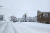
Advertisement Advertise With Us
Advertisement Advertise With Us