

Watch out for flying Halloween decorations as rain, wind on tap for Atlantic Canada
Advertisement
Read this article for free:
or
Already have an account? Log in here »
To continue reading, please subscribe:
Monthly Digital Subscription
$1 per week for 24 weeks*
- Enjoy unlimited reading on winnipegfreepress.com
- Read the E-Edition, our digital replica newspaper
- Access News Break, our award-winning app
- Play interactive puzzles
*Billed as $4.00 plus GST every four weeks. After 24 weeks, price increases to the regular rate of $19.95 plus GST every four weeks. Offer available to new and qualified returning subscribers only. Cancel any time.
Monthly Digital Subscription
$4.99/week*
- Enjoy unlimited reading on winnipegfreepress.com
- Read the E-Edition, our digital replica newspaper
- Access News Break, our award-winning app
- Play interactive puzzles
*Billed as $19.95 plus GST every four weeks. Cancel any time.
To continue reading, please subscribe:
Add Free Press access to your Brandon Sun subscription for only an additional
$1 for the first 4 weeks*
*Your next subscription payment will increase by $1.00 and you will be charged $16.99 plus GST for four weeks. After four weeks, your payment will increase to $23.99 plus GST every four weeks.
Read unlimited articles for free today:
or
Already have an account? Log in here »
ST. JOHN’S – As Hurricane Melissa churns toward Newfoundland, another storm is set to bring rain and wind to the Maritimes for Halloween.
Heavy rains and high winds are expected in parts of the western Maritimes beginning on Friday morning, said Bob Robichaud, a warning preparedness meteorologist with the Canadian Hurricane Centre.
The system should move across the region during the day, bringing the rain to Prince Edward Island and eastern Nova Scotia by the time children are ready to head out for trick or treating, he said in an interview Thursday.
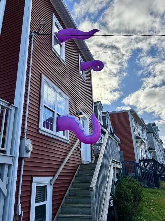
Residents will want to keep an eye on their inflatable Halloween decorations, Robichaud said.
“If there’s a way to deflate them during the day tomorrow, that’s probably a good idea,” he said.
“Around suppertime, especially in central and western parts of Nova Scotia and southern New Brunswick, there’s going to be an opportunity to reinflate them and for the kids to get out, most likely,” he added. “But it’s really a window of opportunity, because there is more wind coming after that.”
Environment Canada has issued rainfall warnings for the Atlantic coast of Nova Scotia, from Yarmouth to Ecum Secum, on Friday. Up to 50 or 60 millimetres could fall in some areas, with winds gusting up to 70 kilometres an hour.
The weather agency is calling for up to 40 millimetres of rain and 70 km/h winds in much of the rest of the province.
The same conditions are on tap for Prince Edward Island and New Brunswick on Friday, though the southern coast of New Brunswick will see a bit more rain, Environment Canada says.
Bathurst, N.B., was among several Maritime communities to reschedule trick or treating and other Halloween activities to Saturday.
Meanwhile, Hurricane Melissa was on track to barrel past Bermuda Thursday night. The storm was moving north at 44 km/h on Thursday afternoon, with maximum winds clocked at 167 km/h.
Melissa was expected to reach Atlantic Canadian waters on Friday afternoon and roar by the southeast tip of Newfoundland’s Avalon Peninsula overnight Friday.
As it passed, the hurricane was expected to shift to a post-tropical storm.

Most models on Thursday showed Melissa passing offshore and not making landfall in Newfoundland, Robichaud said. And the worst of Melissa’s winds are expected to be east of the storm’s centre, even farther from land.
The storm will still “pack a bit of a punch” as it goes by, Robichaud said, bringing a short period of heavy rain and high waves along some coastlines.
Environment Canada said waves could reach seven metres in some areas. Combined with a storm surge, the waves could cause flooding, particularly along the southwest coasts of the Burin and Avalon Peninsulas.
The conditions in Newfoundland will be determined by Melissa’s westward track, Robichaud said. If the storm passes closer to shore, or makes landfall, its impacts could be worse, he said.
This report by The Canadian Press was first published Oct. 30, 2025.
Related Articles
Haiti, Jamaica and Cuba pick up the pieces after Melissa's destruction

Advertisement Advertise With Us
Advertisement Advertise With Us