

Pacific Northwest braces for more heavy rain, after a powerful storm caused flooding and rescues
Advertisement
Read this article for free:
or
Already have an account? Log in here »
To continue reading, please subscribe:
Monthly Digital Subscription
$0 for the first 4 weeks*
- Enjoy unlimited reading on winnipegfreepress.com
- Read the E-Edition, our digital replica newspaper
- Access News Break, our award-winning app
- Play interactive puzzles
*No charge for 4 weeks then price increases to the regular rate of $19.00 plus GST every four weeks. Offer available to new and qualified returning subscribers only. Cancel any time.
Monthly Digital Subscription
$4.75/week*
- Enjoy unlimited reading on winnipegfreepress.com
- Read the E-Edition, our digital replica newspaper
- Access News Break, our award-winning app
- Play interactive puzzles
*Billed as $19 plus GST every four weeks. Cancel any time.
To continue reading, please subscribe:
Add Free Press access to your Brandon Sun subscription for only an additional
$1 for the first 4 weeks*
*Your next subscription payment will increase by $1.00 and you will be charged $16.99 plus GST for four weeks. After four weeks, your payment will increase to $23.99 plus GST every four weeks.
Read unlimited articles for free today:
or
Already have an account? Log in here »
PORTLAND, Ore. (AP) — Pacific Northwest residents braced for another round of heavy rain Wednesday after a powerful storm clobbered the region the day before, swelling rivers, closing roads and prompting high water rescues.
By early Wednesday, some areas in the Cascade mountain range in Washington were reporting “impressive” rain rates near or exceeding a half-inch (1.2 centimeters) per hour, the National Weather Service in Seattle posted on X. Paradise on Mount Rainier picked up 3.25 inches (8.2 centimeters) of rain in 10 hours, it said.
Schools announced closings and delays over flooding concerns. Some roads were closed due to mudslides.
On Tuesday, the first in what is expected to be a series of damaging storms this week caused power outages, flooding and school closures in parts of Oregon and Washington. Drivers had to navigate debris slides and water that closed roads and submerged vehicles.
Fire officials northeast of Seattle said rescue crews used inflatable kayaks to pull people from stranded cars, and carried another person about a mile (1.6 kilometers) to safety after they were trapped in the woods by rising water.
Washington Gov. Bob Ferguson said in a post on X on Tuesday night that the state’s Emergency Operations Center had moved to its highest activation level because of the rain and wind.
Major rivers are forecast to crest later this week
Forecasters warned that the worst was still to come, with some major rivers expected to crest later in the week. The Skagit River near Concrete, which is northeast of Seattle, was forecast to rise more than 15 feet (4.6 meters) above major flooding levels by Thursday, which would break a record, according to the National Water Prediction Service.
Harrison Rademacher, a meteorologist with the weather service in Seattle, described the atmospheric river soaking the region as “a jet stream of moisture” stretching across the Pacific Ocean “with the nozzle pushing right along the coast of Oregon and Washington.”
The weather service forecast several days of heavy rainfall along the coast and more than a foot (30 centimeters) of new snow in the northern Rockies in northwestern Wyoming. Flood watches were in effect, with scattered flash flooding possible along the coast and into the Cascade Mountains through midweek.
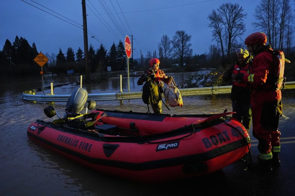
Along Interstate 5 between Seattle and Portland, firefighters conducted five rescues for people who tried to drive on flooded roads, including a semitruck driver, said Malachi Simper, spokesperson for Lewis County Fire Protection District #5. Authorities also rescued a family of six from their home in Chehalis, he said, adding that the road to the house was under about 4 feet (1.2 meters) of water at the time. None of those rescued were injured, he said.
Authorities go door to door warning about flooding
Police said deputies went door to door in certain neighborhoods to warn residents of imminent flooding, and evacuated a mobile home park along the Snohomish River, northeast of Seattle. The city of Snohomish issued an emergency proclamation due to flooding, while in Auburn, south of Seattle, workers installed temporary flood control barriers along the White River.
On the Columbia River, farther south near the Oregon border, the city of Longview said it was opening a severe weather shelter Tuesday night.
Another storm system is expected to bring rain to the region starting Sunday, Rademacher said. “The pattern looks pretty unsettled going up to the holidays,” he said.
Portland transportation officials warned of an increased risk of car crashes because of hydroplaning or driving through flooded roads.
In southeast Alaska, an arctic blast could bring wind chills as low as minus 50 degrees (minus 45.6 Celsius) in Skagway and minus 15 degrees (minus 26 Celsius) in the capital city, Juneau, according to the weather service.
Severe weather also targets the Upper Midwest

Meanwhile, a fast-moving storm tracking across the Upper Midwest on Tuesday was forecast to bring freezing rain, high winds and heavy snow.
Weather forced some schools to close or move to virtual lessons.
Most of the Dakotas were under a high wind warning. Winds of up to 65 mph (105 kph) were expected Tuesday, said Connor Smith, meteorologist for the weather service in Bismarck.
Parts of central and northern Minnesota and northwest Wisconsin could see heavy snow, with a mix of winter weather forecast across the Twin Cities metro and southwest Minnesota, with potentially strong winds to follow, said Ryan Dunleavy, meteorologist for the weather service in the Twin Cities.
Commuters should allow for extra time traveling, he said. The storm was expected to head into the Great Lakes region by Wednesday.