Powerful thunderstorm spawns tornadoes, large hail in Westman
Advertisement
Read this article for free:
or
Already have an account? Log in here »
To continue reading, please subscribe:

Digital Subscription
One year of digital access for only $205*
- Enjoy unlimited reading on winnipegfreepress.com
- Read the E-Edition, our digital replica newspaper
- Access News Break, our award-winning app
- Play interactive puzzles
*First annual payment billed as $205.00 + GST for one year. This annual subscription will automatically renew at $233.00 + GST every 52 weeks (10% off the regular annual price of $259.35). Offer available to new and qualified returning subscribers only. Cancel any time.
To continue reading, please subscribe:
Add Free Press access to your Brandon Sun subscription for only an additional
$1 for the first 4 weeks*
- Enjoy unlimited reading on winnipegfreepress.com
- Read the E-Edition, our digital replica newspaper
- Access News Break, our award-winning app
- Play interactive puzzles
*Your next Brandon Sun subscription payment will increase by $1.00 and you will be charged $17.95 plus GST for four weeks. After four weeks, your payment will increase to $24.95 plus GST every four weeks.
Read unlimited articles for free today:
or
Already have an account? Log in here »
Hey there, time traveller!
This article was published 12/06/2024 (772 days ago), so information in it may no longer be current.
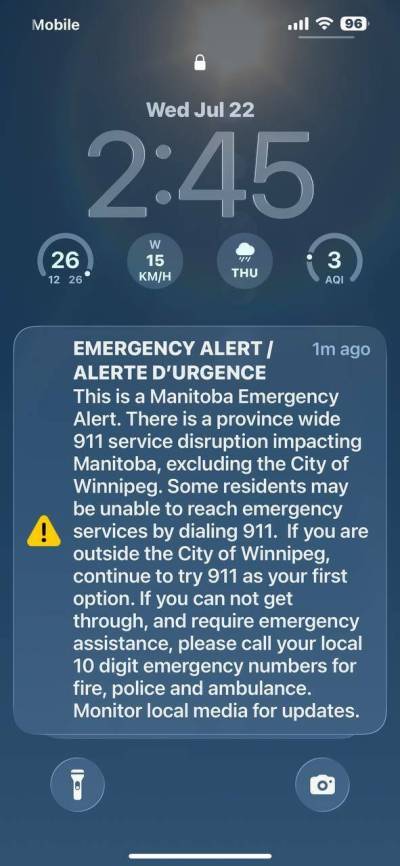
BRANDON — Cellphones in western Manitoba rang out with emergency alerts on Wednesday afternoon as a powerful thunderstorm from Saskatchewan brought tornadoes and loonie-sized hail.
Tornadoes were reported near Rivers, north of Brandon and in La Rivière, Environment and Climate Change Canada meteorologist Dave Carlsen told the Brandon Sun.
“This storm started in Saskatchewan just around noon today and it progressively moved eastward into southern Manitoba,” Carlsen said. “There’s been some large to very large hail reported with the storm and a few reports of tornadoes.”
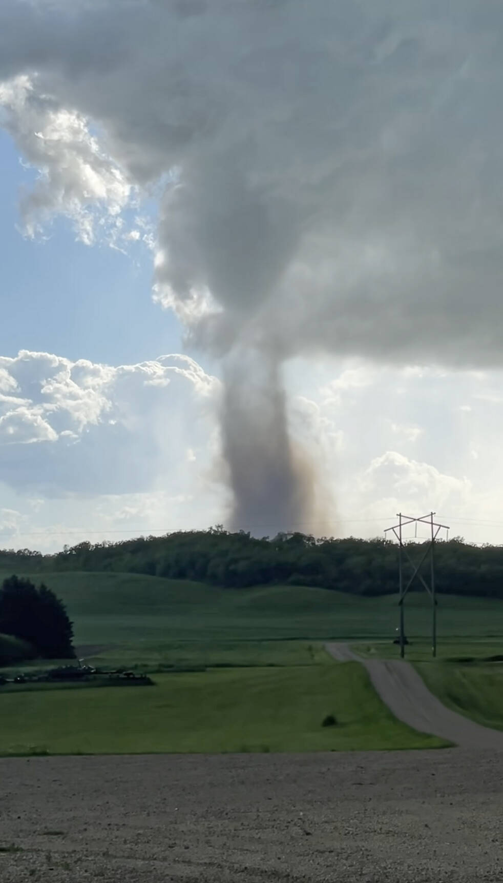
A suspected tornado touches down near Bruxelles, southeast of Brandon early Wednesday evening. (Jennifer Dalgleish/Facebook)
He said it was too early to determine the exact number of tornadoes that touched down, but said reports had been received from storm chasers who are considered trusted sources of information.
“It hasn’t been anything so far that’s been huge or damaging that we know of,” he said. “They’ve been more the dusty-looking tornadoes rather than the big ones you see down in Oklahoma, but that is certainly subject to change as the day goes on.”
Tornado warnings were also issued for the municipalities of Glenboro-South Cypress, North Cypress-Langford and Oakland-Wawanesa, the towns of Neepawa and Carberry, the Municipality of Lorne, the rural municipalities of Victoria and Stanley and Winkler and Morden.
Around 5 p.m., the forecast predicted the storm would continue producing severe weather such as tornadoes, large hail and damaging winds until it moved into North Dakota and Minnesota around 7 or 8 p.m.
While the hail in Manitoba was closer to the size of quarters and loonies, Carlsen said it was almost as big as golf balls when the storm was over Yorkton, Sask.
“This is the biggest day of severe weather that we’ve had,” Carlsen said. “I think we did have a day in May that was farther east or around Winnipeg and in the Red River Valley, but in terms of Westman, southwestern Manitoba, it looks like this is the first day like this this year.”
In such a storm, Carlsen recommended people stay indoors and off the highways.

“Especially keep an eye on the sky and pay attention to your favourite weather information source so you can get the warnings from Environment Canada quickly.”
In Brandon, emergency alerts were sent to phones around 4:40 p.m. Carlsen said those alerts are sent out when the Doppler radar shows a “certain threshold of rotational velocity as well as certain reflectivity signatures.”
Once conditions capable of sustaining a tornado are identified, warnings are issued. Warnings will also be sent out if there is a severe thunderstorm and reliable reports of tornadoes are sent in to meteorologists.
The Doppler radar also indicated there might have been wind speeds approaching 100 kilometres an hour at one point, but no on-the-ground reports of that were received.
— Brandon Sun
Related Articles
Five Westman twisters kick off tornado season
Advertisement Advertise With Us
Advertisement Advertise With Us