After July floods took four lives, Nova Scotia plans flood plain mapping by 2026
Advertisement
Read this article for free:
or
Already have an account? Log in here »
To continue reading, please subscribe:

Digital Subscription
One year of digital access for only $205*
- Enjoy unlimited reading on winnipegfreepress.com
- Read the E-Edition, our digital replica newspaper
- Access News Break, our award-winning app
- Play interactive puzzles
*First annual payment billed as $205.00 + GST for one year. This annual subscription will automatically renew at $233.00 + GST every 52 weeks (10% off the regular annual price of $259.35). Offer available to new and qualified returning subscribers only. Cancel any time.
To continue reading, please subscribe:
Add Free Press access to your Brandon Sun subscription for only an additional
$1 for the first 4 weeks*
- Enjoy unlimited reading on winnipegfreepress.com
- Read the E-Edition, our digital replica newspaper
- Access News Break, our award-winning app
- Play interactive puzzles
*Your next Brandon Sun subscription payment will increase by $1.00 and you will be charged $17.95 plus GST for four weeks. After four weeks, your payment will increase to $24.95 plus GST every four weeks.
Read unlimited articles for free today:
or
Already have an account? Log in here »
Hey there, time traveller!
This article was published 15/11/2023 (1049 days ago), so information in it may no longer be current.
HALIFAX – A plan is now in place to create the kind of detailed flood plain maps that some of Nova Scotia’s emergency managers have said they lacked when torrential flooding occurred in July.
Byron Rafuse, deputy minister of the Department of Municipal Affairs and Housing, told a legislature committee Wednesday it’s expected the mapping will be conducted over the next three fiscal years and be completed by 2026.
The $10-million program will allow municipalities to identify where there is a high risk of flooding, and to “address issues” where homes and other infrastructure have been built in flood-prone areas, Rafuse said.
“These plans are being developed for the use of the municipalities,” he said in an interview after the hearing. “It will be given to them to identify the (flood risk) areas and they can plan accordingly and develop the rules for their communities.”
The maps will indicate the potential extent of water accumulation in various areas during coastal and inland flooding events.
The mapping uses lidar — a remote sensing technology that creates elevation maps of the earth’s surface. It also uses other data sources, including surveys of structures such as bridges and culverts, and existing data on river depth and coastal basins, and considers water flows, tides, and precipitation.
That data, along with climate projections, is used to create models showing potential hazard areas for flooding events considered to occur every 20 years and every 100 years. The maps will project climate conditions in the year 2050 and 2100.
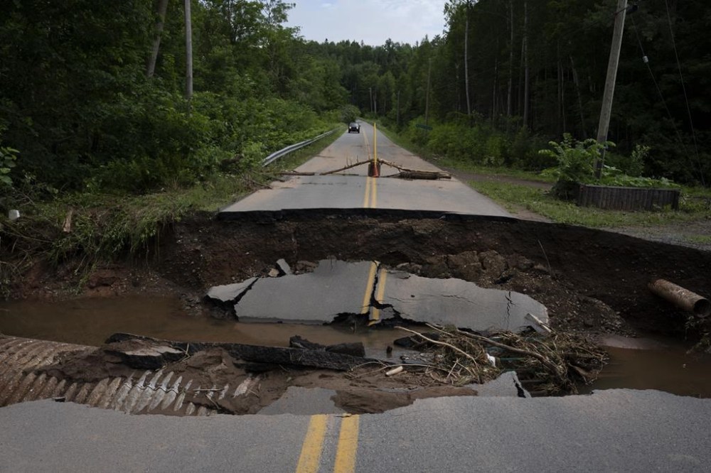
Two six-year-old children, a 14-year-old girl and a 52-year-old man died in the West Hants Regional Municipality during flooding in July, when torrential rainfall hit some parts of the province. West Hants has said that at the time of the disaster its emergency management officials didn’t have access to detailed flood plain maps.
Rafuse said mapping for the West Hants region is underway and will be completed by April 1, 2024.
Tim Webster, leader of the applied geomatics research group at the Nova Scotia Community College, said in a telephone interview that his group will be participating in the mapping work in western Nova Scotia.
“For some municipalities, it’s going to be incredibly valuable because some of them have nothing,” he said.
However, he noted that the projections for the modelling isn’t as severe as what occurred in West Hants, where flash floods swept large trucks off secondary highways. Webster said he believes it would be wise to include such extreme rainfall events in the mapping as well.
“I think it would be smart to actually try to model the West Hants event and … document it perhaps more rigorously than we currently are doing,” he said.
In a 2020 report by the University of Waterloo’s Intact centre on climate change, the authors gave Nova Scotia low grades for flood planning, noting that it is the only province in Atlantic Canada to delegate responsibility for mapping to local governments.
Blair Feltmate, director of the Intact centre, said in an email Wednesday that flood plain maps are helpful in showing where water will flow in major downpours, and can help municipalities identify areas where they should install infrastructure to divert water.

However, he said the work of diverting floodwaters with strategically located berms, diversion channels, holding ponds, and giant water storage tanks must take place “in the months and years preceding major storms.”
“If actions have not been taken to act on the guidance of a flood map, generally communities end up deploying thousands of sandbags at the last minute. Sandbags should be the line of last defence against flooding, not the first,” he wrote.
In addition, Feltmate said that there is a danger in citizens placing complete faith in flood plain maps.
“No one — unless they live on a mountain top — should assume they are free of flood risk just because their house does not show up on a flood map. Microburst storms, due to climate change, are more common today than in the past, and that can affect flooding in areas outside of a flood plain,” he wrote.
This report by The Canadian Press was first published Nov. 15, 2023.