

2024 was record-setting year for precipitation at Toronto airport: Environment Canada
Advertisement
Read this article for free:
or
Already have an account? Log in here »
To continue reading, please subscribe:
Monthly Digital Subscription
$1 per week for 24 weeks*
- Enjoy unlimited reading on winnipegfreepress.com
- Read the E-Edition, our digital replica newspaper
- Access News Break, our award-winning app
- Play interactive puzzles
*Billed as $4.00 plus GST every four weeks. After 24 weeks, price increases to the regular rate of $19.95 plus GST every four weeks. Offer available to new and qualified returning subscribers only. Cancel any time.
Monthly Digital Subscription
$4.99/week*
- Enjoy unlimited reading on winnipegfreepress.com
- Read the E-Edition, our digital replica newspaper
- Access News Break, our award-winning app
- Play interactive puzzles
*Billed as $19.95 plus GST every four weeks. Cancel any time.
To continue reading, please subscribe:
Add Free Press access to your Brandon Sun subscription for only an additional
$1 for the first 4 weeks*
*Your next subscription payment will increase by $1.00 and you will be charged $16.99 plus GST for four weeks. After four weeks, your payment will increase to $23.99 plus GST every four weeks.
Read unlimited articles for free today:
or
Already have an account? Log in here »
Hey there, time traveller!
This article was published 03/01/2025 (447 days ago), so information in it may no longer be current.
TORONTO – Environment Canada says two massive summer storms helped catapult Toronto’s Pearson International Airport to its wettest year on record.
Meteorologist Steven Flisfeder says the airport weather station recorded 1,145 millimetres of precipitation in 2024.
That beats out the previous annual record set in 2008 by almost 100 millimetres, and surpasses the 30-year norm by more than 300 millimetres.
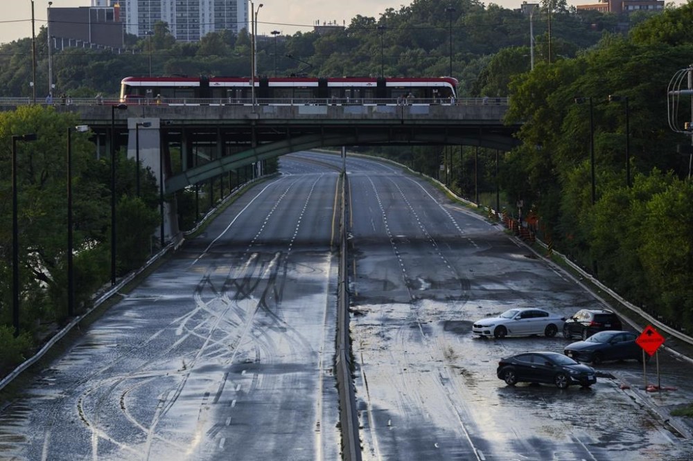
Flisfeder says the airport station was hit by once-in-a-century storms in both July and August that each delivered more than 100 millimetres of rain.
The Insurance Bureau of Canada, a national industry association, says that generated more than $1 billion in insured damages in Ontario, making it the second costliest summer for floods in the province after 2013.
Flisfeder says a station in downtown Toronto was only hit hard by the July storm and ended the year with above-normal precipitation totals, but below the annual record.
He says the vast majority of the province was either right around normal precipitation levels or slightly below, when compared to the 30-year average from 1991 to 2020.
Some areas east of Lake St. Clair in southwestern Ontario were above normal but “didn’t quite break any records,” Flisfeder said in an interview Friday.
He said it shows how severe summer weather is often “extremely localized.”
“We’re seeing similar things with the snow squall activity that’s going on currently in areas southeast of Georgian Bay, where areas near Barrie received upwards of 50 or 60 centimetres of snow so far, and areas just 10, 15 kilometres north received barely any snow,” he said.
The July and August storms each had a 100-year return period, Flisfeder said, or a one per cent chance of taking place in a given year.
To see storms of that magnitude in back-to-back months is “very rare,” Flisfeder said, yet it’s happening with increased regularity.
He said the record-setting result at Pearson reflected the impact of both an El Niño and climate change.
El Niño, the natural recurring climate cycle tied to shifting warm water in the Pacific Ocean, typically boosts summer precipitation for southern Ontario. Climate change, driven by the burning of fossil fuels, is characterized by a warming atmosphere capable of holding more moisture that comes down in severe precipitation.
This report by The Canadian Press was first published Jan. 3, 2025.