Tropical Storm Keli forms and is second cyclone now in central Pacific Ocean

Advertisement

Advertise with us

HONOLULU (AP) — Two tropical cyclones were swirling across the ocean southeast of Hawaii after developing on Monday but were not expected to cause any issues for the islands.

Read this article for free:


or

Already have an account? Log in here »

To continue reading, please subscribe:

Subscribe and receive a limited-edition Free Press branded hat or tote.

Digital Subscription

One year of digital access for only $205*

  • Enjoy unlimited reading on winnipegfreepress.com
  • Read the E-Edition, our digital replica newspaper
  • Access News Break, our award-winning app
  • Play interactive puzzles

*First annual payment billed as $205.00 + GST for one year. This annual subscription will automatically renew at $233.00 + GST every 52 weeks (10% off the regular annual price of $259.35). Offer available to new and qualified returning subscribers only. Cancel any time.

To continue reading, please subscribe:

Add Free Press access to your Brandon Sun subscription for only an additional

$1 for the first 4 weeks*

  • Enjoy unlimited reading on winnipegfreepress.com
  • Read the E-Edition, our digital replica newspaper
  • Access News Break, our award-winning app
  • Play interactive puzzles
Start now

*Your next Brandon Sun subscription payment will increase by $1.00 and you will be charged $17.95 plus GST for four weeks. After four weeks, your payment will increase to $24.95 plus GST every four weeks.

Hey there, time traveller!
This article was published 28/07/2025 (426 days ago), so information in it may no longer be current.

HONOLULU (AP) — Two tropical cyclones were swirling across the ocean southeast of Hawaii after developing on Monday but were not expected to cause any issues for the islands.

Hurricane Iona is the first named storm of the hurricane season in the central Pacific and emerged Sunday from a tropical depression to become a Category 1 hurricane in roughly a day. It was trekking west over warm, open waters.

“It’s pretty high confidence that it’s not going to have any direct impacts on the islands,” said Derek Wroe with the National Weather Service in Honolulu.
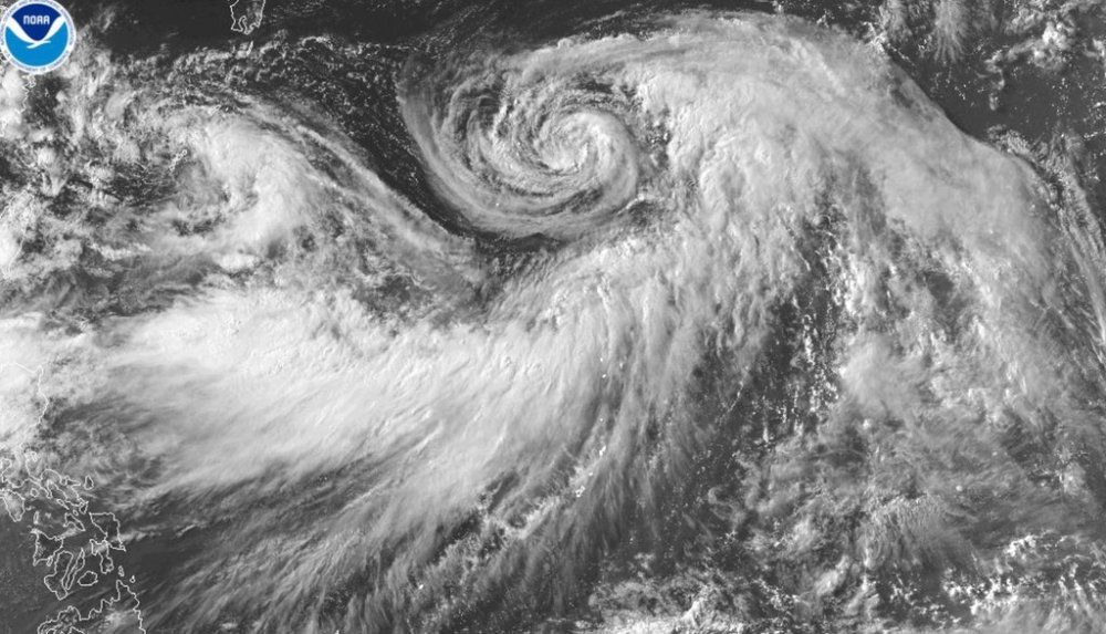
This satellite image provided by the National Oceanic and Atmospheric Administration (NOAA) shows Hurricane Iona forming in the central Pacific Ocean, Monday, July 28, 2025. (NOAA via AP)

The hurricane is centered well south of Hawaii and an indirect impact will be downward pressure winds from the hurricane, creating dry and breezy conditions.

“There’s a lot of upward motion in the hurricane and then there’s usually compensating downward motion,” Wroe said. “That should be the case here as well. So it will be dry, it will be breezy.”

Those were the conditions that were prevalent when Hurricane Dora also passed well south of the islands in August 2023, and the associated winds led to the conditions that exacerbated the deadliest fire in the U.S. in over a century.

The blaze raced through the historic town of Lahaina and resulted in the deaths of 102 people.

He said there are concerns that conditions with Hurricane Iona could be at or near red flag criteria.

“That said … wouldn’t be anything close to what we saw during that time with Hurricane Dora. The situation is just not that strong,” he said.

The pressure gradient created by Hurricane Dora created gusts that clocked in at 50 mph (80 kph) in central Maui and well over 60 mph (96 kph) on the Big Island. There were no instruments in West Maui two years ago to measure wind.

“We don’t expect anything even close to that,” he said, with possible localized gusts of over 40 mph (64 kph) with winds running around 20 mph (32 kph).

On Monday, Iona was about 810 miles (1,303 kilometers) southeast of Honolulu, the U.S. National Hurricane Center in Miami said. No coastal watches or warnings were in effect. Iona is expected to strengthen and become a major hurricane Tuesday before weakening around the middle of the week.

The hurricane has maximum sustained winds of about 85 mph (137 kph). It was moving in a generally westward direction at about 13 mph (21 kph).

A second weather system also formed. Tropical Storm Keli had maximum sustained winds of 40 mph (65 kph).

It was about 1,030 miles (1,658 kilometers) southeast of Honolulu and was moving west at about 12 mph (19 kph). It may strengthen over the next day but, like Iona, should lose power around the middle of the week.

Wroe said he didn’t expect any direct impact from this storm on Hawaii either.

The administrator of the Hawaii Emergency Management Agency on Monday hosted a statewide conference call with all counties, during which the National Weather Service provided an assessment and status of the storms.

“All counties are monitoring,” agency spokesperson Kiele Amundson said in an email.

Another indirect impact from these storms could be swells, but Wroe said they are relatively small and moving westward and won’t create anything significant.

However, a large swell is headed toward Hawaii after being generated several hundred miles east of New Zealand.

It’s expected to arrive in Hawaii about Thursday, about the same time the storms pass the state.

“People might wrongly attribute the swell energy to be from these tropical systems, but they’re actually not,” he said.

He anticipates high surf advisory to be issued for the south shores of the Hawaiian Islands, with a surf of 10 feet (3 meters) or higher.

Report Error Submit a Tip

More Stories

‘In Normandy, we remember’

Aaron Epp 4 minute read Preview

‘In Normandy, we remember’

Aaron Epp 4 minute read Yesterday at 6:23 PM CDT

Travelling nearly 7,000 km from his home in France to Winnipeg gave Gabriel Zaranski a new perspective on warfare.

“It’s very different to speak about war in school (than) to speak with real people who (have fought) in a war,” he said. “We can feel the emotion when they speak … The testimony has more impact when it’s real soldiers.”

Zaranski is one of 14 Grade 12 students from Bayeux, a town in France’s Normandy region, in Winnipeg this week for a learning tour.

The students, who attend Lycée Arcisse de Caumont high school, met on Saturday with veterans from the Queen’s Own Cameron Highlanders of Canada, a local military regiment, to discuss their studies and the regiment’s role in the Second World War.

Read
Yesterday at 6:23 PM CDT

Special teams woes hurt Bombers in loss to Argos

Ken Wiebe 7 minute read Preview

Special teams woes hurt Bombers in loss to Argos

Ken Wiebe 7 minute read Yesterday at 8:06 PM CDT

They’ve been the most consistent of the three phases in the Winnipeg Blue Bombers arsenal this season.

A port in the proverbial storm, throughout this topsy-turvy campaign of ups-and-downs, the special-teams units have been supplying strength to a group that is still searching for consistency with only four games left in the regular season.

That’s what made this momentary lapse so costly in a 30-28 loss to the Toronto Argonauts on Friday at Princess Auto Stadium.

“We didn’t keep up our end of the bargain. And that hurts our football team, hurts our chances of winning games,” said Blue Bombers special teams ace Tanner Cadwallader. “And if we want to win close games. we’ve got to be a whole lot better than that. And we will. We’re going to come in (on Saturday for the film session) and go through it with a fine-tooth comb and just work a little bit harder.”

Read
Yesterday at 8:06 PM CDT

Nuit Blanche ready to wow in city’s core

Conrad Sweatman 5 minute read Preview

Nuit Blanche ready to wow in city’s core

Conrad Sweatman 5 minute read Friday, Sep. 25, 2026

For one night each September, downtown Winnipeg becomes an art gallery — an amusement park, even.

During Nuit Blanche, which takes place tonight, 3D projections spill across the Exchange District, The Forks and St. Boniface, and thousands flood the city core to take in live music, DJs and installations.

“There really isn’t anything like it. I know every promoter probably tells you that, but we are the only event that works at this scale in the fall,” says Nuit Blanche general manager Kurt Tittlemier.

“Culture Days Manitoba is run with the mission statement to make free, accessible artistic programming to all,” he adds, referring to the multi-week national festival, “and Nuit Blanche is our flagship event.”

Read
Friday, Sep. 25, 2026

Blue Bombers whiff on their opportunities to put game away

Taylor Allen 6 minute read Preview

Blue Bombers whiff on their opportunities to put game away

Taylor Allen 6 minute read Friday, Sep. 25, 2026

In theory, Bryce Perkins has a simple job.

When it’s third and short, the Winnipeg Blue Bombers trot out the short-yardage quarterback, and all he has to do is plunge forward for a yard or two to make everyone on his sideline happy.

But on Friday night against the visiting Toronto Argonauts, he went above and beyond his job description.

The Bombers, down 24-21 with six minutes left, faced a third-and-one from their own end when Perkins found a hole and burst through it for a 76-yard touchdown to put the home team in front 28-24 late.

Read
Friday, Sep. 25, 2026

Positive anticipation is growing about major housing developments underway in Winnipeg’s downtown

Gabrielle Piché 10 minute read Preview

Positive anticipation is growing about major housing developments underway in Winnipeg’s downtown

Gabrielle Piché 10 minute read Friday, Sep. 25, 2026

If traffic is light and the wind is down, Somia Sadiq is able to hear the roar of Winnipeg Jets fans twice: first through her window, then on TV.

From her apartment view high above downtown, she can look out at Graham Avenue’s painted pedestrian landscape, see construction cranes and hear the heavy equipment at work as massive housing projects take shape at The Forks, at what used to be Portage Place shopping centre and at the former Hudson’s Bay building.

Sadiq has lived at 300 Main for 2 1/2 years, a few steps from the city’s famous, windy and reopened-to-pedestrians Portage Avenue intersection. At 42 storeys, it’s the tallest building in Winnipeg.

She is among 18,000 downtown residents who will soon be joined by thousands of others attracted to the city’s core by the new wave of major construction projects.

Read
Friday, Sep. 25, 2026

Today’s horoscope

Georgia Nicols 4 minute read Preview

Today’s horoscope

Georgia Nicols 4 minute read 2:00 AM CDT

MOON ALERT: There are no restrictions to shopping or important decisions. The moon is in Aries.

ARIES (March 21-April 19)

This is a wonderful, energetic day. The moon in your sign is dancing with lucky Jupiter promoting domestic peace and happiness. It’s a great day for business. But your top choice will be to socialize, enjoy fun activities with kids, check out sporting events or slip away on a vacation. .

TAURUS (April 20-May 20)

Read
2:00 AM CDT