

Nor’easter without a name to bring ocean flooding and high winds to US East Coast
Advertisement
Read this article for free:
or
Already have an account? Log in here »
To continue reading, please subscribe:
Monthly Digital Subscription
$0 for the first 4 weeks*
- Enjoy unlimited reading on winnipegfreepress.com
- Read the E-Edition, our digital replica newspaper
- Access News Break, our award-winning app
- Play interactive puzzles
*No charge for 4 weeks then price increases to the regular rate of $19.00 plus GST every four weeks. Offer available to new and qualified returning subscribers only. Cancel any time.
Monthly Digital Subscription
$4.75/week*
- Enjoy unlimited reading on winnipegfreepress.com
- Read the E-Edition, our digital replica newspaper
- Access News Break, our award-winning app
- Play interactive puzzles
*Billed as $19 plus GST every four weeks. Cancel any time.
To continue reading, please subscribe:
Add Free Press access to your Brandon Sun subscription for only an additional
$1 for the first 4 weeks*
*Your next subscription payment will increase by $1.00 and you will be charged $16.99 plus GST for four weeks. After four weeks, your payment will increase to $23.99 plus GST every four weeks.
Read unlimited articles for free today:
or
Already have an account? Log in here »
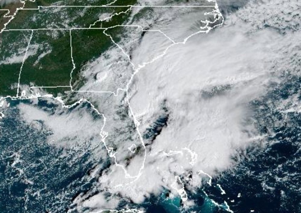
A storm without a name was expected to bring flooding to the East Coast from South Carolina to New Jersey and high winds to New York City over the holiday weekend.
While the storm affecting the eastern U.S. wasn’t tropical, two other tropical storms were churning in the Atlantic Ocean on Friday, including Tropical Storm Jerry that dumped heavy rain on the northern Leeward Islands. There were rescues and one person died after being swept away by water in the French territory of Guadeloupe, officials said.
Two tropical storms were also in the eastern Pacific Ocean. Tropical Storm Priscilla dissipated into a remnant low, but what remained was expected to bring heavy rain from coastal Mexico into the U.S. Southwest through the weekend. Flood watches were issued for parts of Arizona, California and Nevada.
In the U.S., the unnamed storm sent sea water again into Charleston, South Carolina, where three dozen roads were closed as floodwaters reached well above ankles before receding. Friday morning’s high tide reached 8.46 feet (2.58 meters) which was the 13th highest in more than a century of recorded data in Charleston Harbor.
Tidal flooding also closed roads for a few hours along the Georgia and Florida coasts.
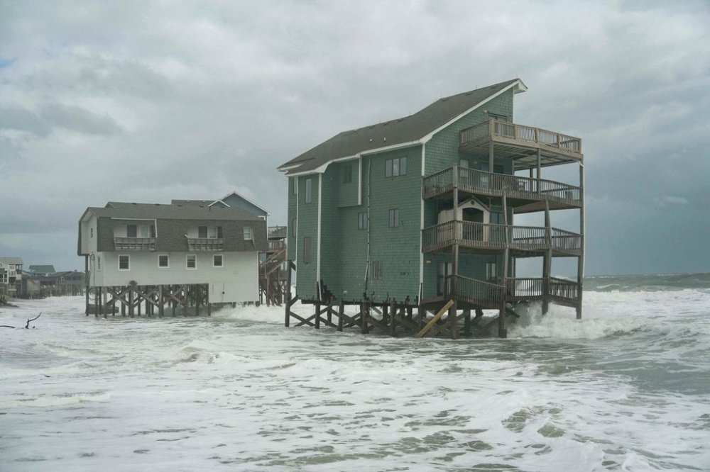
The persistent, strong winds from the unnamed nor’easter and unusually high king tides, when the moon is closer than usual to the Earth, had forecasters predicting more problems this weekend along the North Carolina Outer Banks, where a series of storms that moved well offshore have destroyed 10 houses in the past month and breached dunes. The pilings of some homes in Buxton were already in the waves before the worst of the storm.
Officials warned highway N.C. 12 on Hatteras and Ocracoke islands would likely have to close again because of ocean overwash.
The worst conditions will spread north this weekend and into the Columbus Day holiday on Monday as the storm moves up from Florida. Forecasters warned people on the shores of Delaware and New Jersey to prepare for major coastal flooding.
A high wind watch was issued for parts of New York City and Long Island where forecasters warned gusts of up to 60 mph (95 kph) were possible Sunday.
Out in the Atlantic, Tropical Storm Jerry was pulling away Friday from the northern Leeward Islands, but heavy rain continued.
In Guadeloupe, searchers found the body of a man inside a car that was swept away by floodwaters after scouring the area by boat, helicopter and two drones. Eight people were rescued on board two boats, the government said.
“Pointe-à-Pitre is badly affected and is struggling to drain this water. Many places are flooded,” Thierry Devimeux, the island’s government leader, told radio station Guadeloupe La 1ère.
Areas of Guadeloupe, Antigua and Barbuda and the Dutch Caribbean territory of Saint Maarten saw as much as 8 inches (20 centimeters) of rain, closing government offices and schools.
Jerry was centered about 750 miles (1,205 kilometers) south of Bermuda and moving north-northwest at 15 mph (24 kph) with maximum sustained winds of 50 mph (85 kph).
Way up in the northern Atlantic, Subtropical Storm Karen formed far from land, then lost its subtropical characteristics less than 24 hours later, the hurricane center said.
A subtropical storm tends to have a wide zone of strong winds farther from its center compared to a tropical storm, which generates heavier rains, according to the U.S. National Weather Service.
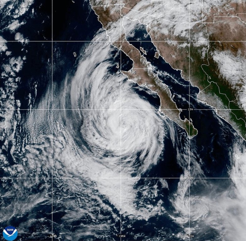
In the Pacific, tropical storm warnings associated with Tropical Storm Raymond were in effect from Manzanillo to Cabo Corrientes, Mexico; for Las Islas Marias; and for Baja California Sur from Los Barriles to Santa Fe, Mexico.

A couple vehicles had already been swept away by floodwaters in New Mexico late Friday afternoon. In northern Arizona, washes that are normally dry were filled with fast-flowing water.
Raymond was forecast to remain off the southwestern coast of Mexico through Friday before nearing Baja California Sur on Saturday and Sunday.
Raymond was about 145 miles (230 kilometers) west of Manzanillo. It had maximum sustained winds of 50 mph (85 kph) and was moving northwest at 17 mph (28 kph), forecasters said.
___
Associated Press writer Jacques Billeaud in Phoenix contributed to this report.