NASA looks at Louisiana delta system, eyes global forecasts

Advertisement

Advertise with us

MIKE ISLAND, La. (AP) — Erosion, sinking land and sea rise from climate change have killed the Louisiana woods where a 41-year-old Native American chief played as a child. Not far away in the Mississippi River delta system, middle-school students can stand on islands that emerged the year they were born.

Read this article for free:


or

Already have an account? Log in here »

To continue reading, please subscribe:

Subscribe and receive a limited-edition Free Press branded hat or tote.

Digital Subscription

One year of digital access for only $205*

  • Enjoy unlimited reading on winnipegfreepress.com
  • Read the E-Edition, our digital replica newspaper
  • Access News Break, our award-winning app
  • Play interactive puzzles

*First annual payment billed as $205.00 + GST for one year. This annual subscription will automatically renew at $233.00 + GST every 52 weeks (10% off the regular annual price of $259.35). Offer available to new and qualified returning subscribers only. Cancel any time.

To continue reading, please subscribe:

Add Free Press access to your Brandon Sun subscription for only an additional

$1 for the first 4 weeks*

  • Enjoy unlimited reading on winnipegfreepress.com
  • Read the E-Edition, our digital replica newspaper
  • Access News Break, our award-winning app
  • Play interactive puzzles
Start now

*Your next Brandon Sun subscription payment will increase by $1.00 and you will be charged $17.95 plus GST for four weeks. After four weeks, your payment will increase to $24.95 plus GST every four weeks.

Hey there, time traveller!
This article was published 29/06/2021 (1868 days ago), so information in it may no longer be current.

MIKE ISLAND, La. (AP) — Erosion, sinking land and sea rise from climate change have killed the Louisiana woods where a 41-year-old Native American chief played as a child. Not far away in the Mississippi River delta system, middle-school students can stand on islands that emerged the year they were born.

NASA is using high-tech airborne systems along with boats and mud-slogging work on islands for a $15 million, five-year study of these adjacent areas of Louisiana. One is hitched to a river and growing; the other is disconnected and dying.

Scientists from NASA and a half-dozen universities from Boston to California aim to create computer models that can be used with satellite data to let countries around the world learn which parts of their dwindling deltas can be shored up and which are past hope.
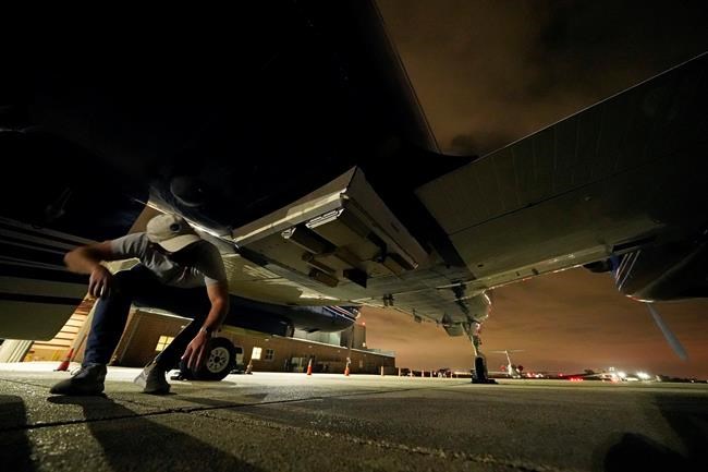
Jack Bush, electrical engineer and radar operator for the NASA Jet Propulsion Laboratory, checks the antennas of a K-band phenomenology airborne radar (Air SWOT), underneath a King Air twin engine airplane, before one of many flights over the Atchafalaya River delta to measure surface water velocity, at New Orleans Lakefront Airport, in New Orleans on Wednesday, April 7, 2021. (AP Photo/Gerald Herbert)

“If you have to choose between saving an area and losing another instead of losing everything, you want to know where to put your resources to work to save the livelihood of all the people who live there,” said lead scientist Marc Simard of NASA’s Jet Propulsion Laboratory.

While oceans rise because of climate change, the world’s river deltas — home to seafood nurseries and more than 300 million people — are sinking and shrinking.

To figure out where to shore up dying deltas, NASA is studying water flowing in and out of Louisiana’s Atchafalaya and Terrebonne basins, sediment carried by it, and plants that can slow the flow, trap sediment and pull carbon from the air.

Louisiana holds 40% of the nation’s wetlands, but they’re disappearing fast — about 2,000 square miles (5,180 square kilometers) of the state have been lost since the 1930s. That’s about 80% of the nation’s wetland losses, according to the U.S. Geological Survey.

Using two kinds of radar and a spectrometer that measures more colors than the human eye can distinguish, high-altitude NASA airplanes have been collecting information such as water height, slope, sediment, and the types and density of plants. Some measurements are as precise as a couple of centimeters (less than an inch).

On boats and islands, scientists and students from across the country take samples and measure everything from currents to diameters of trees. Their findings will be used to calibrate the airborne instruments.

“I’ve been working here 15 years, and one of the toughest parts about working in a delta is you can only touch one little piece of it at any one time and understand one little piece of it at one time,” said Robert Twilley, a professor of oceanography and coastal sciences at Louisiana State University. “Now we have the capability of working with NASA to understand the entire delta.”

The Mississippi River drains 41% of the continental United States, collecting 150 million tons (130 million metric tons) of sediment per year. But, largely because of flood-prevention levees, most sediment shoots into the Gulf of Mexico rather than settling in wetlands.
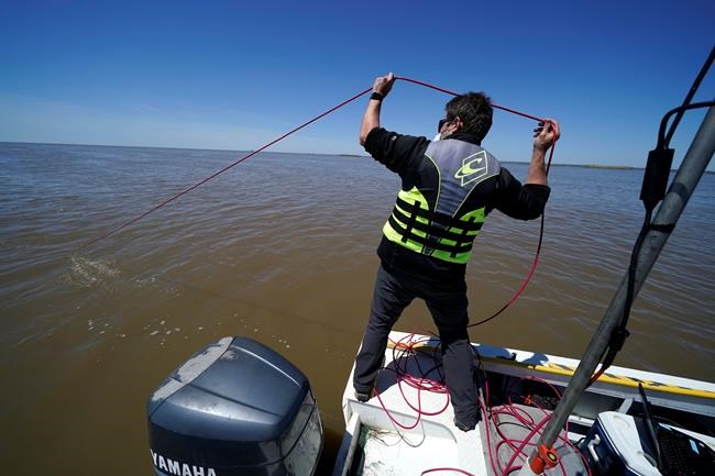
Cedric Fichot, Boston University assistant professor Department of Earth and Environment drops a compact optical profiling system, measuring light and particle density, into the Wax Lake Delta in the Atchafalaya Basin, in St. Mary Parish, La., Friday, April 2, 2021. NASA is using high-tech airborne systems along with boats and mud-slogging work on islands for a $15 million study of these two parts of Louisiana's river delta system. (AP Photo/Gerald Herbert)

“Deltas are the babies of the geological timescale. They are very young and fragile, in a delicate balance of sinking and growing,” NASA states on the Delta-X project website.

In geological time, young means thousands of years. On that scale, Louisiana’s Wax Lake Delta is taking its first breaths. It dates to 1942, when the Army Corps of Engineers dug an outlet from the lake to reduce flood threats to Morgan City, about 20 miles (32 kilometers) away. Sediment from the Atchafalaya River filled the lake, then began creating islands in the Gulf.

The new islands are thick with black willows and, in spring, thigh-high butterweed topped with small yellow flowers.

Older wetlands in areas surveyed by Delta-X aircraft are more diverse, their soil rich with humus from generations of plants. Along nearby Hog Bayou, blue buntings and scarlet tanagers dart through magnolia branches and skinks skitter up trees. In swamps, ospreys nest atop bald cypresses and alligators float in the water below.

In addition to working at LSU, Twilley has spent about nine years as executive director of Louisiana Sea Grant College Program, which uses the Wax Lake Delta as a classroom for middle- and high-school students.

“We take kids and make them stand on land that was formed the year they were born.” Twilley said.

In contrast, the adjacent Terrebonne Basin is shrinking so rapidly that the government is paying to move the Isle de Jean Charles band of Biloxi-Chitimacha-Choctaw Indians from a vanishing island to higher ground.

That band isn’t the only Native American group losing ground.
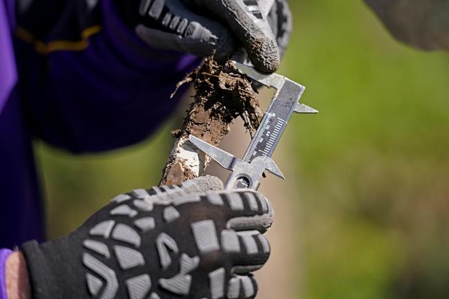
Robert Twilley, an LSU scientist and co-lead investigator of the Delta X research project, examines a quick-frozen sample of earth to learn how much sediment has been added to the ground at Mike Island part of the Wax Lake Delta in the Atchafalaya Basin, in St. Mary Parish, La., Friday, April 2, 2021. NASA is using high-tech airborne systems along with boats and mud-slogging work on islands for a $15 million study of these two parts of Louisiana's river delta system. (AP Photo/Gerald Herbert)

“The wooded areas we used to run through as children — they’re dead,” said Chief Shirell Parfait-Dardar of the Grand Caillou/Dulac Band of Biloxi-Chitimacha Indians, based less than 50 miles (80 kilometers) from the Wax Lake Delta.

“Ghost forests” are common in degrading deltas where salt water intrudes as land sinks and erodes, LSU’s Twilley said.

Louisiana is considering two projects that would divert Atchafalaya River sediment to build land in the Terrebonne Basin, but a decision is more than a year away, according to the state Coastal Restoration and Preservation Authority.

Delta-X’s study gets downright granular. A California Institute of Technology team that studies how sediment moves and is deposited on Earth and other planets will analyze the amounts of sediment in high- and low-tide water samples, breaking the particles down into about 100 sizes.

One way LSU researchers measure how much land has been formed by sediment involves sprinkling white feldspar dust on the ground.

They return to see how deeply it’s buried by new sediment. They do that by injecting liquid nitrogen into hollow tubes to freeze the dirt and muck around them. When the tubes are pulled up, the frozen “popsicles” show a white ring. They measure from there to the top.

In the Terrebonne Basin, such sedimentation can’t keep up with subsidence and sea level rise. “Thus the wetlands basically drown,” Twilley said.

Planes and boats went out in March and April and will go out again in fall for a second set of measurements. And two international satellites are scheduled for launch next year, each carrying one of the two kinds of radar used over Louisiana.
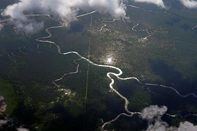
Hog Bayou, part of the Wax Lake Delta in the Atchafalaya Basin, is seen from a plane in St. Mary Parish, La., Tuesday, May 25, 2021. In geological time, young means thousands of years. On that scale, Louisiana's Wax Lake Delta is taking its first breaths. (AP Photo/Gerald Herbert)

To gauge how plants affect water movement, long-wavelengths of L-band radar can measure water level changes in open and vegetated channels, NASA’s Simard said. And high-frequency Ka-band radar can measure surface height of open water, showing how it slopes — and where it’s moving.

“All of the tools they’re bringing to bear is really impressive,” said Indiana University sedimentary geologist Douglas Edmonds, who is not part of the project but has worked with many of the researchers.

“The project itself is putting a finger on a really essential question for a lot of deltas around the world — how this deltaic land is formed and what processes take it away,” he said.

___

Follow Janet McConnaughey on Twitter: @JanetMcCinNO

Report Error Submit a Tip

More Stories

Memories of East Selkirk evoked on Zoon Monkman’s new album

Ben Waldman 4 minute read Preview

Memories of East Selkirk evoked on Zoon Monkman’s new album

Ben Waldman 4 minute read 6:00 AM CDT

At the dawn of the MP3 era, an adolescent Zoon Monkman didn’t have the money for an iPod or a Microsoft Zune, the short-lived competitor to Apple’s revolutionary personal-listening device.

What the recording artist from Brokenhead Ojibway Nation did have in his backpack was the catalogue for the Scholastic Book Club, where only one product demanded attention: an AM-FM radio pen that scoured the airwaves for connection with every click.

For Monkman — a Polaris Music Prize-nominated musician who records as Zoon and pioneered the “moccasingaze” genre, which blends the dreamy textures of shoegaze with the rhythms and energies of Indigenous song — his mother’s gift of the ballpoint pen was a means of both self-discovery and the development of his musical taste.

During lonely days as an elementary student at East Selkirk’s Happy Thought School, the device was also a recess-hour tether to distant worlds, where artists such as Feist, Avril Lavigne and Broken Social Scene were introduced by the enthusiastic voice of a man who called himself Ace Burpee.

Read
6:00 AM CDT

$60M, six-storey Harbourview Terrace due to open in June 2028

Aaron Epp 4 minute read Preview

$60M, six-storey Harbourview Terrace due to open in June 2028

Aaron Epp 4 minute read Friday, Aug. 7, 2026

They donned high-vis vests and brandished shovels with gold-coloured blades Friday morning at the ceremonial groundbreaking for a multi-family residential development in northeast Winnipeg.

Concord Projects has started construction of Harbourview Terrace, the inaugural development by two-year-old real estate company Foxhill Properties. Located in North Kildonan at 1820 De Vries Ave., the $60-million, six-storey apartment building will contain 179 units.

Founder and president Frank Koch-Schulte, who runs the company with his wife Alisha, said Foxhill wants to develop and manage properties with integrity.

“This is kind of like my opportunity to try to do things our way, which I feel is a way that keeps tenants in mind,” Koch-Schulte said. “We live in this neighbourhood. We’re very much invested in seeing quality housing go here.”

Read
Friday, Aug. 7, 2026

South Osborne: doing it right

Editorial 4 minute read Preview

South Osborne: doing it right

Editorial 4 minute read 2:00 AM CDT

Every year, Time Out, which publishes listings magazines, websites and apps for 333 cities around the world, creates a list of the world’s coolest neighbourhoods.

Read
2:00 AM CDT

Conservatives tell Carney to show ‘backbone’ as trade team heads back to Washington

Craig Lord, The Canadian Press 4 minute read Preview

Conservatives tell Carney to show ‘backbone’ as trade team heads back to Washington

Craig Lord, The Canadian Press 4 minute read Updated: Yesterday at 5:01 PM CDT

OTTAWA - Canada's top trade negotiators are heading back to Washington this week for more meetings with the Trump administration as the Opposition Conservatives urge Prime Minister Mark Carney to stop making concessions in pursuit of a tariff-free deal.

Negotiations between Canada and the United States have ramped up in recent weeks ahead of an Aug. 19 deadline that would see a range of Canadian exports hit with 50 per cent tariffs.

Canada-U.S. Trade Minister Dominic LeBlanc and Janice Charette, Canada's chief negotiator, will be back in Washington this week for another round of talks, LeBlanc's spokesman Gabriel Brunet told The Canadian Press on Sunday.

Canada's trade team has met with U.S. Trade Representative Jamieson Greer twice in the past two weeks. Brunet said talks have broadly covered the newly threatened duties, existing sectoral tariffs and renegotiations of the Canada-U.S.-Mexico agreement, or CUSMA.

Read
Updated: Yesterday at 5:01 PM CDT

Letters, August 10

7 minute read Preview

Letters, August 10

7 minute read 3:00 AM CDT

Horrors. Is Donald Trump correct? I think so. The bans on U.S. liquor are discriminatory. How could they be anything else? Provinces don’t ban alcohol from any other country.

Read
3:00 AM CDT

Hopes, memories persist long after ceremonies end

Deborah Schnitzer 5 minute read 6:00 AM CDT

In my time, we did not have graduation ceremonies for pre-kindergarten, kindergarten or grade school. There may have been cookies and juice before we went to high school after Grade 8, but we were never gowned, portraited and diploma-ed. I vaguely remember a white poplin dress with a yellow bow somewhere along the way, but it is an image that drifts in and out of focus with a context I can’t verify.

I must have had some ceremony at the end of high school, but as a misfit, plump and bewildered, high school was no picnic and I have brushed away the particulars.

I did not attend my undergraduate university ceremony as I was readying myself for a May wedding my mother was not pleased to design. When I received my doctorate, years later, I had two boys and a husband who understood every one of my misgivings about whether or not I could succeed.

During that last graduation, I opened the manila envelope given to me as I walked across the stage only to find a rather severe notice stating I would not be degreed unless I returned outstanding library books.