

Perfect storm means frantic flood fight
Advertisement
Read this article for free:
or
Already have an account? Log in here »
To continue reading, please subscribe:
Monthly Digital Subscription
$1 per week for 24 weeks*
- Enjoy unlimited reading on winnipegfreepress.com
- Read the E-Edition, our digital replica newspaper
- Access News Break, our award-winning app
- Play interactive puzzles
*Billed as $4.00 plus GST every four weeks. After 24 weeks, price increases to the regular rate of $19.00 plus GST every four weeks. Offer available to new and qualified returning subscribers only. Cancel any time.
Monthly Digital Subscription
$4.75/week*
- Enjoy unlimited reading on winnipegfreepress.com
- Read the E-Edition, our digital replica newspaper
- Access News Break, our award-winning app
- Play interactive puzzles
*Billed as $19 plus GST every four weeks. Cancel any time.
To continue reading, please subscribe:
Add Winnipeg Free Press access to your Brandon Sun subscription for only
$1 for the first 4 weeks*
*$1 will be added to your next bill. After your 4 weeks access is complete your rate will increase by $0.00 a X percent off the regular rate.
Read unlimited articles for free today:
or
Already have an account? Log in here »
Hey there, time traveller!
This article was published 26/03/2009 (6037 days ago), so information in it may no longer be current.
Manitoba flood officials are dealing with “an almost unprecedented” series of circumstances as they confront ice jams, the snow falls and a huge volume of water heads towards Manitoba from the U.S., flood forecaster Alf Warkentin said this afternoon.
But he said it’s too early to say if the snow that fell in the past couple of days has worsened the flood situation in the Red River Valley.
“It’s quite a weather mess, quite a hydrologic mess we’re in,” Warkentin told reporters at the legislature.

He said while the cold weather has exacerbated flood problems by freezing culverts and making river ice jams more difficult to clear, it could also be “an ally” over the next several days, slowing the melt and the tide of water heading towards the city.
Public Works and Government Services Canada (PWGSC) has restricted public access to areas around the St. Andrews Lock and Dam at Lockport until the threat of flooding has passed.
With ice jams forcing water levels to rise at the St. Andrews Lock and Dam site, and flooding occurring in facilities on site, public access to the lock and public areas on the west side of the Red River facility is being restricted.
This closure is effective immediately and will remain in effect until further notice.
Some five to 10 centimetres of snow have fallen over the last 24 hours, and 20 cm have recently accumulated over the eastern portions of the Red River watershed, while 10 cm have fallen west of the river.
“The snow certainly isn’t welcome but at the same time the cold weather is kind of offsetting the (negative) effects,” Warkentin said.
The Red River is rising less rapidly now due to the cold weather. The province is reviewing crest predictions, and will update crest forecasts tomorrow.
The river level in downtown Winnipeg was 18.7 feet at 9 a.m., but has declined since an ice jam at St. Andrews got unstuck. A level of 18 feet or higher in the city is considered to be at flood stage.
The river level at the floodway inlet is over the entrance lip and water is now flowing naturally into the floodway, the province said. Operation of the floodway gates will start as soon as the ice has moved from the area, but government officials said today they can’t predict when that will occur.
They said there is a risk of ice jams occurring in the city of Winnipeg during the next few days.
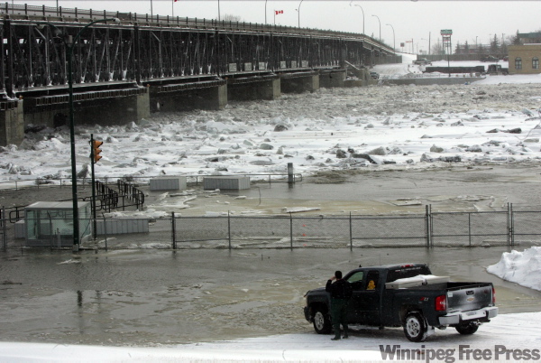
Serious ice jams developed on the Red from the St. Andrews area to south of Selkirk during the past 24 hours. A large jam several kilometres south of Lockport yesterday raised levels above flood stage and caused numerous homes to flood in areas just upstream.
The ice jam broke at about 8 a.m. today, allowing river levels just south of it to decline by several feet.
Despite extensive ice cutting and breaking activities, provincial officials said there is the possibility of further ice jams at Selkirk and north to Breezy point.
Susan Roberecki, the province’s deputy chief medical officer of health, said residents who are using well water in flood affected areas should boil it before consuming it.
Residents should also have their well water tested after the flooding has subsided to ensure it is has not been contaminated, she said.
Related Articles
Military ready to help Manitoba flood victims
Advertisement Advertise With Us
Advertisement Advertise With Us