

From ‘inconvenience’ to second-biggest
Officials seeking sandbaggers on three rivers
Advertisement
Read this article for free:
or
Already have an account? Log in here »
To continue reading, please subscribe:

Digital Subscription
One year of digital access for only $205*
- Enjoy unlimited reading on winnipegfreepress.com
- Read the E-Edition, our digital replica newspaper
- Access News Break, our award-winning app
- Play interactive puzzles
*First annual payment billed as $205.00 + GST for one year. This annual subscription will automatically renew at $233.00 + GST every 52 weeks (10% off the regular annual price of $259.35). Offer available to new and qualified returning subscribers only. Cancel any time.
To continue reading, please subscribe:
Add Free Press access to your Brandon Sun subscription for only an additional
$1 for the first 4 weeks*
- Enjoy unlimited reading on winnipegfreepress.com
- Read the E-Edition, our digital replica newspaper
- Access News Break, our award-winning app
- Play interactive puzzles
*Your next Brandon Sun subscription payment will increase by $1.00 and you will be charged $17.95 plus GST for four weeks. After four weeks, your payment will increase to $24.95 plus GST every four weeks.
Read unlimited articles for free today:
or
Already have an account? Log in here »
Hey there, time traveller!
This article was published 16/04/2009 (6377 days ago), so information in it may no longer be current.
Once thought to be no more than an "inconvenience," the 2009 Red River flood is now projected to be the second biggest since the 1800s, provincial officials said Wednesday.
Alf Warkentin, the province’s senior flood forecaster, said Winnipeggers should brace for a Red River crest of 22.6 feet at James Avenue, only two feet lower than 1997’s Flood of the Century.
"It’s a very serious concern for the city," he said Wednesday.
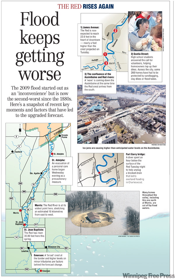
Just a day earlier, the province had projected a downtown Winnipeg crest of 21.8 feet, terming this year’s flood the third worst in 100 years.
But by Wednesday afternoon, government officials had again upgraded the seriousness of the 2009 deluge, calling it the second worst ever on the portion of the Red from St. Jean Baptiste to the floodway inlet just south of Winnipeg.
They also estimated that as of Wednesday, the level of the Red in downtown Winnipeg would have reached 30.3 feet — equal to the Great Flood of 1950 — were it not for the floodway and other flood mitigation efforts carried out since then, such as the Portage diversion and the Shellmouth Dam.
Officials again asked for sandbaggers Wednesday evening to help build and raise dikes on three rivers as hundreds of high school students who had volunteered during the day went home.
Volunteers who can work this morning are asked to call 311 immediately, emergency measures co-ordinator Randy Hull said.
"We need to change the muscle," he said, thanking 600 volunteers who helped build or raise dikes along the Red River at Scotia Street and Glenwood Crescent Wednesday.
The dikes on Scotia were about 35 per cent complete yesterday, while Glenwood dikes were just getting underway.
Dikes at all of those properties, along with several others along the Seine and Assiniboine rivers, should be completed today, when the province predicts the Red River will rise to 22.2 feet at the James Avenue monitoring station.
All told, 100 Winnipeg properties have been asked to raise or build dikes in the northern half of Winnipeg since the province first revised its flood forecast on Tuesday.
Warkentin said several factors have conspired to cause he and his colleagues to upgrade the seriousness of this year’s flood, including a "broad crest" at Emerson, higher water levels than anticipated on minor tributaries of the Red and a large Assiniboine River crest.
"There’s quite a wave coming down the Assiniboine River, and it’s going to get to Winnipeg at just about the worst time — just when the Red River crest is arriving from the south," Warkentin said.
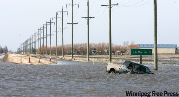
The high flows from the west are due in part to recent difficulties in diverting water into Lake Manitoba because of ice, he said.
Warkentin said due to high flows and fears of ice jamming on the Assiniboine, all residents along the river were phoned Tuesday night to take action for "possibly the highest levels they’ve seen in the last 10 years" between Portage and Winnipeg.
As a precaution Wednesday night, an evacuation began of the personal-care home in St. Adolphe, situated on the Red River. About 40 residents of the home are being moved to Winnipeg.

Don Brennan, a spokesman for the Manitoba Emergency Measures Organization, advised Manitobans to finalize preparations immediately for closing in ring dikes. "Don’t wait until the 11th hour," he said.
Brennan said the overall flood situation is unusual in that there is minor, medium or severe flooding occurring from the western part of the province to the eastern portion of Manitoba.
"People who think they may be compromised by flood waters should be taking proactive steps now to contact your local authorities, find out what you need to do and what type of supplies you need to do it with. I can’t emphasize that enough," he said.
larry.kusch@freepress.mb.ca bartley.kives@freepress.mb.ca
Related Articles
City appeals for sandbaggers today

Advertisement Advertise With Us
Advertisement Advertise With Us