

New provincial park for Duff and his ditch
Tower with deck will offer view of floodway inlet structure
Advertisement
Read this article for free:
or
Already have an account? Log in here »
To continue reading, please subscribe:

Digital Subscription
One year of digital access for only $205*
- Enjoy unlimited reading on winnipegfreepress.com
- Read the E-Edition, our digital replica newspaper
- Access News Break, our award-winning app
- Play interactive puzzles
*First annual payment billed as $205.00 + GST for one year. This annual subscription will automatically renew at $233.00 + GST every 52 weeks (10% off the regular annual price of $259.35). Offer available to new and qualified returning subscribers only. Cancel any time.
To continue reading, please subscribe:
Add Free Press access to your Brandon Sun subscription for only an additional
$1 for the first 4 weeks*
- Enjoy unlimited reading on winnipegfreepress.com
- Read the E-Edition, our digital replica newspaper
- Access News Break, our award-winning app
- Play interactive puzzles
*Your next Brandon Sun subscription payment will increase by $1.00 and you will be charged $17.95 plus GST for four weeks. After four weeks, your payment will increase to $24.95 plus GST every four weeks.
Read unlimited articles for free today:
or
Already have an account? Log in here »
Hey there, time traveller!
This article was published 19/07/2009 (6209 days ago), so information in it may no longer be current.
Earth-moving will begin this summer at the site of a new provincial park south of town that will showcase the Red River Floodway and honour Duff Roblin’s pivotal role in its construction.
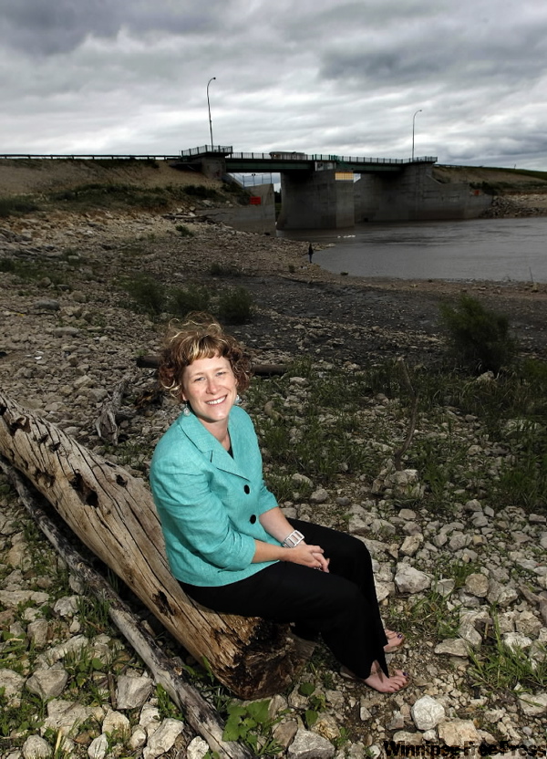
The 138-acre Duff Roblin Provincial Park will feature a tower with a 15-metre-high observation deck that will offer a bird’s eye view of the floodway inlet control structure as well as house interpretive displays, says Kelly-Anne Richmond, the province’s point person on the project.
"You’re going to have a view of the floodway gates when you look in the one direction and when you look in the other direction you’ll be able to view downtown," Richmond said in an interview.
Derek Murray, a partner with architectural firm Scatliff Miller Murray, which is designing the park, said the tower, to be set into a high earthen mound, will symbolize what Roblin accomplished.
"It’s this quiet, unassuming building that yet sort of rises very quietly above the landscape and from there you can see everything," he said.
Other proposed amenities include picnic areas and shelters, interpretive kiosks, walking trails, washrooms, drinking water, fishing facilities, a toboggan hill and a parking lot.
Initial funding for the park was announced in late 2007. The province expects it to attract 25,000 visitors a year once it opens, likely in 2011.
"I think people are really going to be thrilled to go there. The floodway traditionally attracts a lot of attention, especially during flood years or when the gates are operating. And I think we’re going to be able to provide a really neat opportunity for people to learn more about that," Richmond said.
But a group that promotes economic and cultural development in the St. Norbert area thinks the province should have been more ambitious.
"I guess perhaps we conceived an elephant, and I’m a little afraid that maybe the province is bringing forward a mouse. I just think they’ve got to think bigger," said Bob Roehle, co-chairman of Group Action St. Norbert, the group that proposed the park’s creation several years ago.
Roehle said the $3.2 million earmarked so far for the park’s construction by the federal and provincial governments won’t go very far.
The new park will also recognize Roblin’s role in the development of the provincial parks system. The 92-year-old is immensely popular with Manitobans and last year was named the Greatest Manitoban by Free Press readers.
Roehle envisions a more extensive interpretive centre containing a virtual display of the key Red River Valley floods and the damage they would have inflicted without the floodway.
"There’s a whole big story to be told that is interesting to people," he said, adding the province should have consulted more with community groups before finalizing its plans.
Richmond said earth-moving at the site will be carried out in the next few weeks in conjunction with work being done by the Winnipeg Floodway Authority, which is raising nearby Courchene Road.
The province is building a six-metre mound, in which the tower will sit, and doing site preparation for the proposed toboggan hill.
Richmond said the government’s focus right now is the northeast corner of the park, near the floodway gates. Future phases will see development throughout the preserved area.
The Duff Roblin Provincial Park replaces an existing 69-acre park reserve bearing the former Manitoba premier’s name along the north Perimeter Highway.
That park, which opened in 1999, will be maintained and used as a staging area for visitors in what is to be a large recreation complex in the expanded floodway.
larry.kusch@freepress.mb.ca
Duff Roblin Provincial Park

Where is it? It’s a 138-acre parcel of land surrounding the floodway gates, just south of the city. It was officially designated as a provincial park — with little fanfare — last year.
When will it open? Likely in 2011.
Isn’t there already a Duff Roblin park north of the city? Yes, this new park will replace that smaller 69-acre park reserve.
Why is it named after Roblin? The park commemorates two important Manitoba milestones: the construction of the floodway and the establishment of a provincial system of parks. Both were created with the foresight of Roblin, who served as premier from 1958 to 1967 and who was named last year by Free Press readers as the Greatest Manitoban.