

Flood risk in Manitoba low, for now
Advertisement
Read this article for free:
or
Already have an account? Log in here »
To continue reading, please subscribe:
Digital Subscription
One year of digital access for only $75*
- Enjoy unlimited reading on winnipegfreepress.com
- Read the E-Edition, our digital replica newspaper
- Access News Break, our award-winning app
- Play interactive puzzles
*Billed as $5.77 plus GST every four weeks. After 52 weeks, price increases to the regular rate of $19.95 plus GST every four weeks. Offer available to new and qualified returning subscribers only. Cancel any time.
Monthly Digital Subscription
$4.99/week*
- Enjoy unlimited reading on winnipegfreepress.com
- Read the E-Edition, our digital replica newspaper
- Access News Break, our award-winning app
- Play interactive puzzles
*Billed as $19.95 plus GST every four weeks. Cancel any time.
To continue reading, please subscribe:
Add Free Press access to your Brandon Sun subscription for only an additional
$1 for the first 4 weeks*
- Enjoy unlimited reading on winnipegfreepress.com
- Read the E-Edition, our digital replica newspaper
- Access News Break, our award-winning app
- Play interactive puzzles
*Your next Brandon Sun subscription payment will increase by $1.00 and you will be charged $17.95 plus GST for four weeks. After four weeks, your payment will increase to $24.95 plus GST every four weeks.
Read unlimited articles for free today:
or
Already have an account? Log in here »
Hey there, time traveller!
This article was published 19/02/2014 (4476 days ago), so information in it may no longer be current.
The risk of severe spring flooding in southern Manitoba is low, but there’s a big condition attached — winter is far from over.
The preliminary flood outlook provided by the province Tuesday is in keeping with what officials in North Dakota and Saskatchewan have already said in the past few weeks on the potential for spring flooding.
With February more than half over, Manitoba’s flood forecast centre has said based on what it knows now, the flood potential appears to be significantly below that of 2011 and 2013. The province’s first official flood outlook will be near the end of the month.
“It’s still very early,” Premier Greg Selinger said. “What happens in March and April has a significant impact on what kind of flooding we get, how quick the melt is, how much additional precipitation we get.”
Selinger said working in the province’s favour is soil conditions were dry going into winter, which increases the likelihood of more runoff from melting snow being absorbed. Soil moisture conditions in the Red River Valley were below normal in Manitoba and normal in most parts of the U.S.
The same conditions are seen to the west along the Qu’Appelle River, which is mostly below normal. The Saskatchewan River is below normal to normal and the Assiniboine River shows near-normal to above-normal conditions. The Souris River, which empties into the Assiniboine, is near normal to above normal.
“There wasn’t the kind of saturation that we saw in 2011,” Selinger said, referring to a year of record flooding along the Assiniboine River.

Saskatchewan’s Water Security Agency said last week most of that province will see near-normal runoff this spring. Fall precipitation in the 30 days before freeze-up was generally below normal in most of Saskatchewan and winter precipitation was below average in the southeast.
In North Dakota, the National Weather Service has said while the snowpack is near long-term normals, ranging from 20 centimetres in the far south to more than half a metre in the far north and northeast, snow moisture is somewhat less than long-term normals mostly due to the cold, dry winter air masses experienced this winter. Colder air has fluffier snow, but less moisture.
Selinger said the province has hired a new chief flood forecaster to replace Phillip Mutulu, who left last August after six years with the province to work for Stantec Consulting in Calgary.
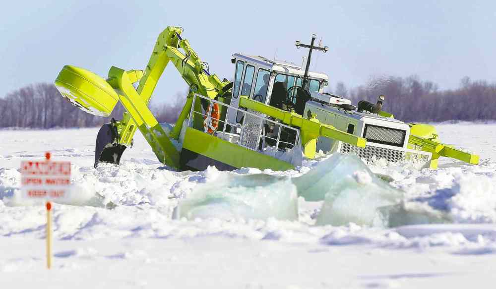
Selinger made his comments as three of the province’s four icebreaking machines and ice cutters started on their second week of work on the Red River north of Selkirk. The goal is to smash ice for about 25 kilometres to the mouth of Lake Winnipeg so it breaks up quickly in the spring thaw and reduces the chances of huge ice jams to the south that cause sudden, overland flooding. This is the eighth spring the Amphibex ice breakers have been deployed.
bruce.owen@freepress.mb.ca

Advertisement Advertise With Us
Advertisement Advertise With Us