

Mapping out Manitoba’s history
Historical society's interactive online feature aids experienced and amateur explorers
Advertisement
Read this article for free:
or
Already have an account? Log in here »
To continue reading, please subscribe:
Monthly Digital Subscription
$1 per week for 24 weeks*
- Enjoy unlimited reading on winnipegfreepress.com
- Read the E-Edition, our digital replica newspaper
- Access News Break, our award-winning app
- Play interactive puzzles
*Billed as $4.00 plus GST every four weeks. After 24 weeks, price increases to the regular rate of $19.95 plus GST every four weeks. Offer available to new and qualified returning subscribers only. Cancel any time.
Monthly Digital Subscription
$4.99/week*
- Enjoy unlimited reading on winnipegfreepress.com
- Read the E-Edition, our digital replica newspaper
- Access News Break, our award-winning app
- Play interactive puzzles
*Billed as $19.95 plus GST every four weeks. Cancel any time.
To continue reading, please subscribe:
Add Free Press access to your Brandon Sun subscription for only an additional
$1 for the first 4 weeks*
*Your next subscription payment will increase by $1.00 and you will be charged $16.99 plus GST for four weeks. After four weeks, your payment will increase to $23.99 plus GST every four weeks.
Read unlimited articles for free today:
or
Already have an account? Log in here »
Hey there, time traveller!
This article was published 07/08/2016 (3557 days ago), so information in it may no longer be current.
While thousands of Manitobans spent the better part of July searching high and low for Pokemon, Gordon Goldsborough was on a different sort of quest.
A past president and current webmaster for the Manitoba Historical Society, Goldsborough has spent the past six years seeking out and mapping historical sites around the province. The result is the society’s interactive map of Manitoba historic sites, one of the best-kept secrets for both locals and tourists alike wanting to explore the province.
The historical society has long been at the forefront of educating Manitobans about their province. Created in 1879 as the Historical and Scientific Society of Manitoba, it ran a private library in Winnipeg long before the city’s first public library opened in 1905. Their inventory of books, manuscripts and maps became the core of Winnipeg’s public collection.
‘I want to know the big picture. Why is it abandoned? What led to that? It can tell us a lot about how Manitoba is changing’– Gordon Goldsborough
The society has had an online presence since 1999, and its ever-expanding website contains essays from its various publications dating back to the 1880s, scans of out-of-print community history books, rare archival images and thousands of biographies of those who played a part in building the province.

Though the website contains information on countless historic sites, Goldsbrough said he found accessing it wasn’t very convenient for an explorer.
“Most of the information on the site was geographically oriented and in a very general sense: for example, walking tours of some of the communities in Winnipeg or communities outside of Winnipeg. They might give street addresses, but I was interested in having the location more exactly defined than that,” he said.
Familiar with mapping technology through his day job as a water scientist at the University of Manitoba, in 2000 Goldsborough created the interactive map by taking the geographic co-ordinates of his finds and plotting them on Google Maps. The first site he logged was an old bank vault in a field south of Deloraine, one of a surprising number of abandoned bank vaults that dot the prairie.
A site’s corresponding web page is populated with historic and modern photographs as well as other background information he can find from the Manitoba Historical Society and other sources.
For Goldsborough, the interactive map offers many advantages over a published document, noting, “When you do a pamphlet or a book it’s pretty much fixed,” whereas the online platform offers “an evolving, organic document.”
He is contacted “almost daily” by people wanting to contribute additional information about one of the sites. Sometimes it’s an old image, a school graduation program or the name of a longtime owner of a business.
“They may just have a little piece of the puzzle, but by everyone contributing we can put it (the history of a site) together fairly thoroughly,” Goldsborough said.
The map, which at last count contained 6,157 sites from every region of the province, can be searched using various filters. You can discover sites by municipality or type of site — perhaps a cemetery, church or monument. If you don’t like those choices, you can enter your own keywords. Goldsborough says the sites that have received the most attention are former schoolhouses, churches and grain elevators.

Mapping and photographing grain elevators has become a top priority for Goldsborough. Why the interest? He says, “They are so iconic. If you ask anyone around the world what they think about when they think of Prairie Canada, they always say grain elevators.”
His urgency to document them is because of their dwindling numbers.
“There are very few left, and they are coming down at an alarming rate. The living memory of these elevators is still there, but it won’t be here much longer,” Goldsborough said.
“Most of the people who remember these elevators are elderly. If we don’t capture the information while they’re still around, we will lose it.”
Goldsborough notes Manitoba is home to what is likely Canada’s oldest grain elevator. The former Lake of the Woods structure at Elva was built in 1897, just two years after what was once recognized by Parks Canada as the nation’s oldest elevator in Fleming, Sask. That structure was torched by an arsonist in 2010.
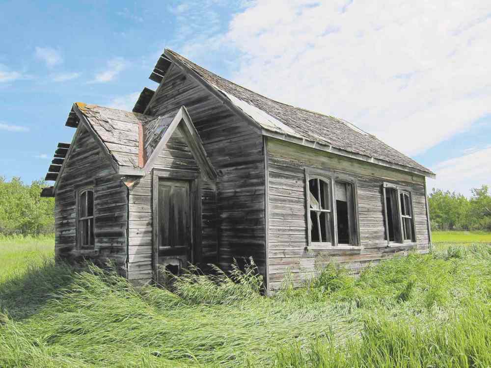
Another map category that has taken on a life of its own is what he calls “abandoned Manitoba”; everything from old mine shafts and quarries to schoolhouses and general stores. The subject has its own section on the Manitoba Historical Society’s website, is a regular segment on CBC Manitoba’s Weekend Morning Show and a “best of” collection of photos and background information will be released in book form this autumn.
For Goldsborough, checking out an abandoned place isn’t just about looking at ruins.
“I want to know the big picture,” he said. “Why is it abandoned? What led to that? It can tell us a lot about how Manitoba is changing.”
As for next steps, Goldsborough has been experimenting with a drone to capture images and videos of sites that can only be seen by air, such as factory foundations or the many Commonwealth Air Training Plan installations that dotted the Prairies during the Second World War. These items will be added to a site’s respective web page. The MHS is also compiling biographical information for each name that appears on a war memorial in Manitoba. This, too, will be added to the monument’s web page.
Longer term plans include an app currently in development where users would be notified whenever they are passing an historic place or a certain type of site they have chosen by category or keyword. This would allow the MHS’ map to become a “truly an immersive, interactive experience” for hardcore explorers or those just out on a Sunday drive.
Goldsborough, who also maintains the historical society’s Facebook page, says it is important that heritage organizations such as the society, municipalities and even weekend explorers share their photos and other historic information online because it makes the information accessible to a new generation of researchers and explorers.

“Hopefully it will engage people who aren’t going to be attracted by the traditional methods of museums and books,” Goldsborough said.
“The reality is that for 20-somethings and even 30-somethings, the way they get their information increasingly is online, so that’s where you’ve got to be.”
You can find the Manitoba Historical Society’s interactive map of Manitoba historic sites at www.mhs.mb.ca. If you would like to contribute information, Gordon Goldsborough can be contacted at gordon@mhs.mb.ca.
Christian Cassidy writes about local history on his blog, West End Dumplings.
