

Peguis waters receding, but province’s flood fears continue
Advertisement
Read this article for free:
or
Already have an account? Log in here »
To continue reading, please subscribe:
Digital Subscription
One year of digital access for only $1.44 a week*
- Enjoy unlimited reading on winnipegfreepress.com
- Read the E-Edition, our digital replica newspaper
- Access News Break, our award-winning app
- Play interactive puzzles
*Billed as $5.77 plus GST every four weeks. After 52 weeks, price increases to the regular rate of $19.95 plus GST every four weeks. Offer available to new and qualified returning subscribers only. Cancel any time.
To continue reading, please subscribe:
Add Free Press access to your Brandon Sun subscription for only an additional
$1 for the first 4 weeks*
- Enjoy unlimited reading on winnipegfreepress.com
- Read the E-Edition, our digital replica newspaper
- Access News Break, our award-winning app
- Play interactive puzzles
*Your next Brandon Sun subscription payment will increase by $1.00 and you will be charged $17.95 plus GST for four weeks. After four weeks, your payment will increase to $24.95 plus GST every four weeks.
Read unlimited articles for free today:
or
Already have an account? Log in here »
Hey there, time traveller!
This article was published 03/04/2017 (3348 days ago), so information in it may no longer be current.
Water from the Fisher River was slowly receding Monday at Peguis First Nation after flooding caused by ice jams forced evacuations from more than 80 homes in the community during the weekend.
Chief Glenn Hudson said the floodwater has receded only about 15 centimetres and the community, located about 180 kilometres north of Winnipeg, has been inundated with water.
“We’re holding steady at 84 evacuations,” Hudson said, reached by cellphone while he toured the community on Monday.
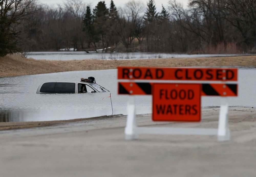
“It’s starting to recede but we still have washed-out roads and obviously concerns regarding the safety of infrastructure throughout the community.”
Floodwater reached some homes; although other homes were dry, they had to be evacuated because water had cut off road access to them. Hudson said it is too early to tell whether some homes may be lost.
“We’ve had a few (homes) inundated by floodwaters but people have been evacuated so once the water recedes, we’ll assess that,” he said. “We’re taking a tour around the community and see where things are at as far as the impacts by flood waters and we’ll go from there. After driving through the community this morning, the water looks like it has dropped maybe about half a foot.”
Hudson said emergency response teams have plenty of experience, having dealt with numerous floods over the years, so they were able to get people out quickly.
He said the evacuees are staying in two Winnipeg hotels.
“People are still out of their homes and there’s no school today because of the road washout. But people tend to be pretty good in facing this type of situation,” he said.
Hudson said crews in Peguis used excavators on Sunday to clear ice jams.
“That’s helping the water recede, along with the cold weather. Last night, it went down to -2 C, so those things are favourable in terms of allowing the water to flow faster,” he said.
Sun, warm weather bode well for city
Flood fears were much lower in Winnipeg on Sunday as city crews and the weather worked together.
“Things are going very well,” city spokesman Ken Allen said. Environment Canada’s forecast for the week — sunshine and above-normal temperatures — will help the city’s flood-planning and operations.
“The situation has stabilized,” Allen said, issuing an update based on the forecast from the province, the operation of the Red River Floodway and ice conditions.
The water level on the Red at James Avenue was at 19.2 feet, very close to the predicted level and down slightly from 19.1 on Sunday.
While water levels at James Avenue are expected to stay around 19 ft. this week, a minor increase may still occur in the next two days as ice moves on the Assiniboine River.
The province said the Red River is expected to crest on Tuesday or Wednesday.
8 local states of emergency
Outside the city, the situation remained tense. Overland flooding continued Monday across much of southern Manitoba, mostly due to ice jams in the drainage network, major rivers and smaller tributaries, Manitoba Infrastructure’s Hydrologic Forecast Centre said in a news bulletin.
Netley Creek was continuing to run very high because ice jamming on the Red River was slowing the creek from draining into the river.
At St. Adolphe and Brunkild, partial ring dike closures were underway or completed.
The Manitoba government said eight states of local emergency had been registered with the province as of Monday due to overland flooding, much of which is due to melting ice which is blocking the flow of rivers: the municipalities of Prairie Lakes, Grassland, Brenda-Waskada, Dufferin, Grey, La Broquerie and Two Borders, and the Town of Carman.
In the Carman area, ice jams on the Boyne River and surface runoff was affecting some homes.
In addition to Peguis, evacuations have also taken place at the Sioux Valley Dakota Nation. The Canadian Red Cross is working with both communities to provide assistance.
The high water advisories issued by the province remained in effect Monday for the Overflowing, Valley and Vermillion rivers.
A flood watch was issued for the lower Assiniboine River from Portage la Prairie to Headingley due to possible ice issues.
Flood watches remained in effect for the Woody, Whitemud and Red Deer rivers.
Meanwhile, the flood watch was lifted from the Whitemouth River.
Flood warnings were issued for Birdtail Creek, the Turtle River and the upper Assiniboine River between the Shellmouth Dam and Holland.
Pembina River levels stabilizing
For Swan River near Minitonas, Fisher River downstream of Dallas, the Morris River, Pipestone Creek and the Red River and Netley Creek near Petersfield, flood warnings remained in effect due to ice jamming.
At Gretna, the province said it was removing the partial dike closure at the border on Monday.
Water levels and flows on the Pembina River, which flows into the Red River south of Manitoba, were stabilizing Monday as ice jams subsided. The Pembina River at Windygates was nearing its second crest, expected to be lower than the first peak.
On the Assinboine River, the Portage Diversion began operation on Friday morning to limit flows on the lower Assiniboine River and to minimize ice jams.
The Assiniboine River’s major tributaries were still increasing including Birdtail and Silver creeks, Arrow, Oak, Little Saskatchewan, Little Souris and Cypress rivers.
The Souris River and its tributaries were continuing to increase due to the run-off from the melt.

Tributaries in the southern Parkland were beginning to rise due to runoff from the Riding Mountain while run-off was starting in the Saskatchewan and Carrot rivers watersheds.
It is expected Highway 75 will remain open but a decision will be made on whether use of a ramp in Morris will be necessary based on conditions over the next few days.
The province said municipal and provincial crews have been working to thaw culverts on a priority basis.
In the city, people can check for flood updates at www.winnipeg.ca. Up-to-date flood information for outside Winnipeg can be found at www.gov.mb.ca/flooding or on Twitter at www.twitter.com/MBGov.
Related Articles
Massive ice jam backs up river, damaging dozens of Carman homes
Advertisement Advertise With Us
Advertisement Advertise With Us
History
Updated on Monday, April 3, 2017 2:53 PM CDT: Updated.