

Powerful thunderstorms pummel southern Manitoba

Advertisement
Read this article for free:
or
Already have an account? Log in here »
To continue reading, please subscribe:

Digital Subscription
One year of digital access for only $205*
- Enjoy unlimited reading on winnipegfreepress.com
- Read the E-Edition, our digital replica newspaper
- Access News Break, our award-winning app
- Play interactive puzzles
*First annual payment billed as $205.00 + GST for one year. This annual subscription will automatically renew at $233.00 + GST every 52 weeks (10% off the regular annual price of $259.35). Offer available to new and qualified returning subscribers only. Cancel any time.
To continue reading, please subscribe:
Add Free Press access to your Brandon Sun subscription for only an additional
$1 for the first 4 weeks*
- Enjoy unlimited reading on winnipegfreepress.com
- Read the E-Edition, our digital replica newspaper
- Access News Break, our award-winning app
- Play interactive puzzles
*Your next Brandon Sun subscription payment will increase by $1.00 and you will be charged $17.95 plus GST for four weeks. After four weeks, your payment will increase to $24.95 plus GST every four weeks.
Read unlimited articles for free today:
or
Already have an account? Log in here »
Hey there, time traveller!
This article was published 16/08/2022 (1428 days ago), so information in it may no longer be current.
Winnipeggers were cleaning up Tuesday after severe thunderstorms across southern Manitoba spawned tornado warnings, dumped baseball-sized hail and more than 100 millimetres of rain, and possibly sparked a house fire.
There were 16 reports of raw sewage backing into homes and 25 of clean water in basements in the wake of Monday’s storms, said City of Winnipeg spokeswoman Lisa Marquardson.
Crews also received 44 reports of plugged catch basins in streets and six in back lanes.
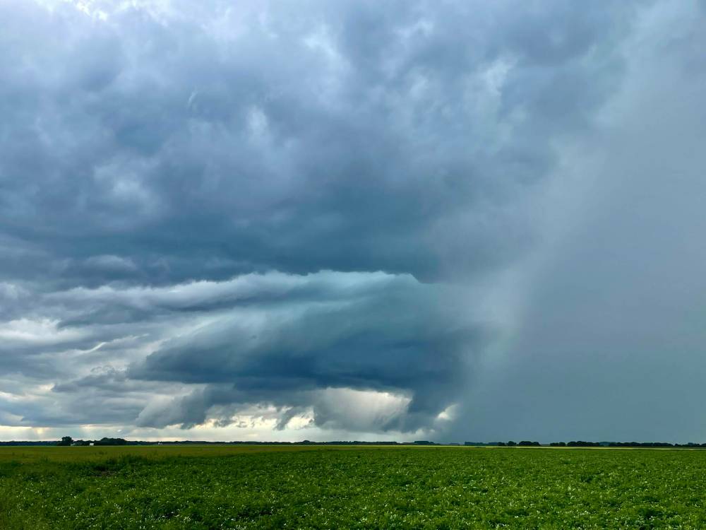
Cory Penner photo
A funnel cloud formed south of Graysville, about 80 kilometres southwest of Winnipeg, around 6:30 p.m. Monday.
“Outside of the usual backups and plugged pumps that happen when a storm like this occurs, our wastewater system worked as it’s designed to and there were no significant issues reported,” Marquardson wrote in an email.
Satellite radar showed rotation in a large storm, but there were no reports of a tornado touching down, said Natalie Hasell, a warning preparedness meteorologist with Environment and Climate Change Canada.
“Luckily, it does not seem that a tornado was actually produced,” she said Tuesday.
The tornado warnings were issued based on what meteorologists were seeing on weather radar while angry-looking clouds moved across the province.
Hasell said there were no confirmed funnel-cloud sightings.
There were frequent lightning strikes in an intense storm that hit Winnipeg and the surrounding area, starting around 6:30 p.m.
Investigators believe one of those strikes caused a fire at a house in the 1000 block of Forbes Road, south of the Perimeter Highway between St. Mary’s and St. Anne’s roads.
The occupants escaped before fire crews arrived shortly after 9 p.m., the City of Winnipeg said in a news release.
The fire was declared under control about 90 minutes later.
Winnipeg Fire Paramedic Service staff used tankers to shuttle water to the home because it is out of the city’s water district.
A man who answered the door at the house, where some damage to the roof was visible, declined to comment.
Joyce Elder, who was staying at a house across the road, said she heard sirens and watched fire trucks arrive, shortly after hearing a lightning strike.
“It wasn’t a bang like a regular thunderstorm,” she said. “You could hear this loud, loud crack. I knew it hit somewhere close.”
Elder said she was glad to hear everyone got out of the house safely.
“It was a little close to home,” she said.
Charleswood resident Brenda Mitchell-Preston noticed water in her basement when she looked down from the top of the stairs around 10:30 p.m.
Using a pump, she filled about a dozen containers, including pails and garbage can, with water, finishing around 1:30 a.m.
“I had this problem with our last deluge a couple months ago,” she said. “I just didn’t want it to spread any further.”
Mitchell-Preston said the water, like the last time, “bubbled through the sewer.”
The home’s drains were cleaned last fall, she said.
As he went from call to call across Winnipeg, Steve Kolbuck, a manager with Roy’s Rooter, said he would likely complete about 14 jobs Tuesday, which is about four times more than normal on a summer day.
He was clearing catch basins and drainpipes that became clogged with roots, while his customers continued to clean up.
“Every time it rains, we get really busy because everyone floods up at once,” said Kolbuck, noting one home had about 10 centimetres of water in its basement.

Neighbours said the roof of this house on Forbes Road, south of the Perimeter Highway between St. Mary’s and St. Anne’s roads, was hit by lightning around 9 p.m. Monday. A man who answered the door declined to comment. (Chris Kitching / Winnipeg Free Press)
He said homeowners should get their residential sewer lines cleaned annually and check their catch basins regularly to avoid clogs.
The highest rainfall total was reported in Transcona, where 114 mm fell in the 24 hours up to 8 a.m. Tuesday, according to Environment Canada.
The average rainfall total for the month of August is 77 mm at the city’s official weather station, located at Winnipeg James Armstrong Richardson International Airport.
A total of 58.8 mm was recorded at the airport following Monday’s storm.
The small community of Vivian, about 35 kilometres east of Winnipeg, received 102.7 mm.
Significant amounts were also reported in East Kildonan (96 mm), Beausejour (91.3 mm), The Forks (90.3 mm), Westwood in St. James (68.4 mm) and Elie (68.3 mm).
Totals between 30 and 60 mm were widespread.
In the Rathwell area, about 100 kilometres southwest of Winnipeg, baseball-sized hail fell around 6:20 p.m., Environment Canada reported.
Winnipeg-based storm photographer Cory Penner tracked that thunderstorm while a tornado warning was in place.
The storm had an “intense” hail shaft and a low-hanging cloud while he watched it south of Graysville, near Carman.
He said the storm “fizzled” shortly after the tornado warning was downgraded to a severe thunderstorm warning.
“For a brief moment, I thought I was going to see a tornado,” said Penner, who saw a twister touch down near Teulon Aug. 2.
Environment Canada is still collecting reports about hail, rain and other storm impacts.
People can submit reports by emailing mbstorm@ec.gc.ca or posting the information on Twitter using #mbstorm in the tweet.

Hasell said it’s not unusual to get such severe storms in mid-August.
“August is still a very active time,” she said. “The season is not over, so I would like people to maintain their vigilance.”
Environment Canada said more thunderstorms are possible Wednesday.
chris.kitching@freepress.mb.ca
Twitter: @chriskitching
Chris Kitching is a general assignment reporter at the Free Press. He began his newspaper career in 2001, with stops in Winnipeg, Toronto and London, England, along the way. After returning to Winnipeg, he joined the Free Press in 2021, and now covers a little bit of everything for the newspaper. Read more about Chris.
Every piece of reporting Chris produces is reviewed by an editing team before it is posted online or published in print — part of the Free Press‘s tradition, since 1872, of producing reliable independent journalism. Read more about Free Press’s history and mandate, and learn how our newsroom operates.
Our newsroom depends on a growing audience of readers to power our journalism. If you are not a paid reader, please consider becoming a subscriber.
Our newsroom depends on its audience of readers to power our journalism. Thank you for your support.
Advertisement Advertise With Us
Advertisement Advertise With Us
History
Updated on Tuesday, August 16, 2022 1:47 PM CDT: Environment Canada info on hail
Updated on Tuesday, August 16, 2022 1:49 PM CDT: Updates description of hail in Rathwell area.
Updated on Tuesday, August 16, 2022 1:49 PM CDT: Updates description of hail in Rathwell area.
Updated on Tuesday, August 16, 2022 1:49 PM CDT: Updates description of hail in Rathwell area.