
Design for Osborne Village cycling route unveiled
Read this article for free:
or
Already have an account? Log in here »
To continue reading, please subscribe:
Monthly Digital Subscription
$0 for the first 4 weeks*
- Enjoy unlimited reading on winnipegfreepress.com
- Read the E-Edition, our digital replica newspaper
- Access News Break, our award-winning app
- Play interactive puzzles
*No charge for 4 weeks then price increases to the regular rate of $19.95 plus GST every four weeks. Offer available to new and qualified returning subscribers only. Cancel any time.
Monthly Digital Subscription
$4.99/week*
- Enjoy unlimited reading on winnipegfreepress.com
- Read the E-Edition, our digital replica newspaper
- Access News Break, our award-winning app
- Play interactive puzzles
*Billed as $19.95 plus GST every four weeks. Cancel any time.
To continue reading, please subscribe:
Add Free Press access to your Brandon Sun subscription for only an additional
$1 for the first 4 weeks*
*Your next subscription payment will increase by $1.00 and you will be charged $16.99 plus GST for four weeks. After four weeks, your payment will increase to $23.99 plus GST every four weeks.
Read unlimited articles for free today:
or
Already have an account? Log in here »
Hey there, time traveller!
This article was published 30/03/2023 (1015 days ago), so information in it may no longer be current.
The City of Winnipeg has unveiled the final design for a key cycling route.
This June, the city will begin building protected bike lanes on River and Stradbrook avenues (from Harkness Avenue to Wellington Crescent), and Wellington Crescent (between River and Stradbrook), as part of a larger road renewal project.
A cycling advocate says the link will add a key connection to the city’s bike route network and help many folks commute.
“We’re really happy to see this moving through. We think it’s a big part of the city network moving forward and it’s something that we feel is going to get used right from the start,” said Mark Cohoe, executive director of Bike Winnipeg.
Cohoe noted the route could help cyclists from parts of St. Vital and Fort Garry head downtown and will serve riders in densely populated Osborne Village.
The city’s website says the project will make travel for cyclists safer and more convenient by using a raised curb to separate bikes from vehicles.
“It’s definitely a safety improvement. Right now, if you look at both Stradbrook and River, it’s mixed traffic. So, if you’re riding your bike on those roadways, you’re mixing in with vehicles and parked cars… You’re more likely to get into a collision in that kind of situation,” said Cohoe. “Mixed traffic with parking on roads like River and Stradbrook with the heavier volumes of traffic is the thing that people find the least friendly to ride on. It’s the thing they fear most.”
The plan includes “two-stage” left-turn areas, where space outside of bike and traffic lanes allows cyclists room to stop outside of the flow of traffic and wait for a safe moment to turn.
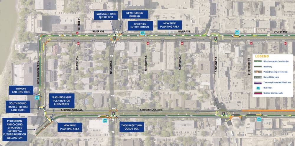
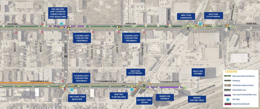
Chris Baker, the city’s active transportation co-ordinator, said the new safety features are meant to help ensure riders of all ages and abilities can travel safely.
“This protected bike lane will separate those on bikes from those in a car by a concrete curb. This really increases the comfort of cycling there. What that does is attract riders who might not be comfortable riding in a different condition, riding on a painted bike lane or riding in mixed traffic,” said Baker.
He said this particular route is a priority in Winnipeg’s pedestrian and cycling strategy and should help the city meet a few different goals.
“Creating a safe and comfortable and high-quality cycling network is critical to encourage more people to use… this mode of transportation. Getting more people on their bikes can reduce traffic congestion (and) it helps the city meet its climate change goals,” said Baker.
The city does not yet know the cost of the project, since it’s part of larger road renewal contracts that are still open for companies to bid on.
Baker noted nearly all of the bike route will be protected from traffic, except for a short, narrower segment of River Avenue east of Harkness Avenue. At that spot, the city proposes to eventually reduce the vehicle speed limit to 30 km/h and possibly add traffic-calming devices.
The routes will also be made safer for pedestrians, Baker said.
“This (project) has some major pedestrian improvements… (including) five new crosswalks that will be upgraded to (a) flashing beacon (to be more visible),” he said.
A survey on the final design has been posted on the city’s website.
Construction on the protected bike lanes is expected to wrap up in October.
joyanne.pursaga@freepress.mb.ca
Twitter: @joyanne_pursaga

Joyanne is city hall reporter for the Winnipeg Free Press. A reporter since 2004, she began covering politics exclusively in 2012, writing on city hall and the Manitoba Legislature for the Winnipeg Sun before joining the Free Press in early 2020. Read more about Joyanne.
Every piece of reporting Joyanne produces is reviewed by an editing team before it is posted online or published in print — part of the Free Press‘s tradition, since 1872, of producing reliable independent journalism. Read more about Free Press’s history and mandate, and learn how our newsroom operates.
Our newsroom depends on a growing audience of readers to power our journalism. If you are not a paid reader, please consider becoming a subscriber.
Our newsroom depends on its audience of readers to power our journalism. Thank you for your support.
History
Updated on Friday, March 31, 2023 3:03 PM CDT: Changes to east from west