

City plan calls for four rapid transit corridors by 2031
Advertisement
Read this article for free:
or
Already have an account? Log in here »
To continue reading, please subscribe:

Digital Subscription
One year of digital access for only $205*
- Enjoy unlimited reading on winnipegfreepress.com
- Read the E-Edition, our digital replica newspaper
- Access News Break, our award-winning app
- Play interactive puzzles
*First annual payment billed as $205.00 + GST for one year. This annual subscription will automatically renew at $233.00 + GST every 52 weeks (10% off the regular annual price of $259.35). Offer available to new and qualified returning subscribers only. Cancel any time.
To continue reading, please subscribe:
Add Free Press access to your Brandon Sun subscription for only an additional
$1 for the first 4 weeks*
- Enjoy unlimited reading on winnipegfreepress.com
- Read the E-Edition, our digital replica newspaper
- Access News Break, our award-winning app
- Play interactive puzzles
*Your next Brandon Sun subscription payment will increase by $1.00 and you will be charged $17.95 plus GST for four weeks. After four weeks, your payment will increase to $24.95 plus GST every four weeks.
Read unlimited articles for free today:
or
Already have an account? Log in here »
Hey there, time traveller!
This article was published 28/10/2011 (5369 days ago), so information in it may no longer be current.
Winnipeg’s new transportation plan calls for the completion of four rapid-transit lines over the next 20 years. The full document can be seen here.
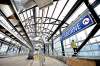
The $1.25-million transportation-planning strategy, unveiled to councillors this morning, calls for the completion of the Southwest Rapid Transit Corridor from downtown to the University of Manitoba and the construction of an eastern corridor along Nairn Avenue to Lagimodiere Boulevard, a western corridor along Portage to Century Street and a northern corridor along Main Street to Burrows Avenue, all by 2031.
The document pegs the the completion of the southwest corridor as the city’s main rapid-transit priority. The first phase of the corridor, a 3.6-kilometre busway between Queen Elizabeth Way and Jubilee Avenue, built at a cost of $138 million, is slated to open in April 2012.

Extending this corridor to Bison Drive will cost $275 million, according to the plan. Upgrading the entire southwest corridor to light rail will cost $700 million.
The report does not state a preference for the route of the second phase of the southwest corridor. An included map shows two options: One running south along Pembina Highway and another jogging through the Parker and Beaumont neighbourhoods to take advantage of a hydro corridor.
The report also suggests two more rapid-transit corridors could be built after 2031 – a southeast corridor from Nairn to Bishop Grandin Boulevard and a northeast corridor from Nairn to the Perimeter Highway.
Along with rapid transit, the report prioritizes the construction of regional roadways over the next 20 years. In the short term, it recommends the widening of Plessis Road, with a railway grade separation, be completed by 2016 at a cost of $75 million.

The plan will be presented to the public at an open house on Wednesday at the Millennium Library. It will also come before two council committees before council debates it on Nov. 16.

Once approved, it will serve as a blueprint for future transportation upgrades in an effort to synchronize transit, traffic and active transportation with residential and commercial development, said public works director Brad Sacher, who noted the city has not done overly well at this task in the past.


Advertisement Advertise With Us
Advertisement Advertise With Us
History
Updated on Friday, October 28, 2011 1:00 PM CDT: Adds link to planning document
Updated on Friday, October 28, 2011 1:18 PM CDT: Adds maps.
Updated on Friday, October 28, 2011 1:32 PM CDT: corrects typo in "southeast"