

Carlsbad Caverns creating digital map of cave system
Advertisement
Read this article for free:
or
Already have an account? Log in here »
To continue reading, please subscribe:
Monthly Digital Subscription
$0 for the first 4 weeks*
- Enjoy unlimited reading on winnipegfreepress.com
- Read the E-Edition, our digital replica newspaper
- Access News Break, our award-winning app
- Play interactive puzzles
*No charge for 4 weeks then price increases to the regular rate of $19.00 plus GST every four weeks. Offer available to new and qualified returning subscribers only. Cancel any time.
Monthly Digital Subscription
$4.75/week*
- Enjoy unlimited reading on winnipegfreepress.com
- Read the E-Edition, our digital replica newspaper
- Access News Break, our award-winning app
- Play interactive puzzles
*Billed as $19 plus GST every four weeks. Cancel any time.
To continue reading, please subscribe:
Add Free Press access to your Brandon Sun subscription for only an additional
$1 for the first 4 weeks*
*Your next subscription payment will increase by $1.00 and you will be charged $16.99 plus GST for four weeks. After four weeks, your payment will increase to $23.99 plus GST every four weeks.
Read unlimited articles for free today:
or
Already have an account? Log in here »
Hey there, time traveller!
This article was published 18/08/2019 (2274 days ago), so information in it may no longer be current.
CARLSBAD, N.M. – The National Park Service is creating a digital map of Carlsbad Caverns National Park to help with repairs and maintenance projects.
The agency is using light detection and ranging equipment to digitally map out the entire cave system in southern New Mexico down to the millimeter, the Carlsbad Current-Argus reports .
The Center for Advanced Spatial Technologies at the University of Arkansas is helping with the $186,000 project, which began in 2015. Staff is shooting images and collecting data using laser lights and measuring the reflected light with hundreds of sensors.
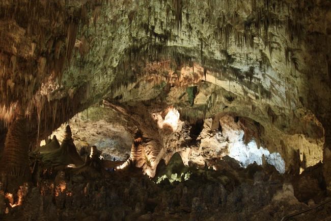
The result is supposed to yield a highly-detailed digital three-dimensional map of the cave system.
“It’s like a big 3D set of data,” said Julie McGilvray, cultural resources program manager at Guadalupe Mountains National Park. “It’s useful for so many things.”
A final draft of the map is expected to be completed by the end of this year.
McGilvray said the result would serve as a planning document for decades as park staff seeks to preserve the cave system for the public’s enjoyment while retaining its historic and cultural significance.
“You have the data you need to make those decisions,” she said.

Claire Gorman, an undergrad student at Yale University studying computer science and architecture, worked on the project for 10 weeks.
She used the ranging equipment data to help create a cultural landscape inventory focusing on viewshed, which is the visual experience a person has while in a certain geographic location.
“In order to preserve it, you need to know what you’re preserving,” Gorman said. “A (cultural landscape inventory) helps to formalize that in a way that is very comprehensive and detailed. It allows you to see the cave from without. This allows you to view the cave in 3D from an outside location.”
___
Information from: Carlsbad Current-Argus, http://www.currentargus.com/