

Flood watch
Advertisement
Read this article for free:
or
Already have an account? Log in here »
To continue reading, please subscribe:
Monthly Digital Subscription
$1 per week for 24 weeks*
- Enjoy unlimited reading on winnipegfreepress.com
- Read the E-Edition, our digital replica newspaper
- Access News Break, our award-winning app
- Play interactive puzzles
*Billed as $4.00 plus GST every four weeks. After 24 weeks, price increases to the regular rate of $19.00 plus GST every four weeks. Offer available to new and qualified returning subscribers only. Cancel any time.
Monthly Digital Subscription
$4.75/week*
- Enjoy unlimited reading on winnipegfreepress.com
- Read the E-Edition, our digital replica newspaper
- Access News Break, our award-winning app
- Play interactive puzzles
*Billed as $19 plus GST every four weeks. Cancel any time.
To continue reading, please subscribe:
Add Winnipeg Free Press access to your Brandon Sun subscription for only
$1 for the first 4 weeks*
*$1 will be added to your next bill. After your 4 weeks access is complete your rate will increase by $0.00 a X percent off the regular rate.
Read unlimited articles for free today:
or
Already have an account? Log in here »
Hey there, time traveller!
This article was published 13/04/2009 (6019 days ago), so information in it may no longer be current.
New developments
Early Sunday morning, the ice jam that had been stuck around Sugar Island north of Selkirk gave way and headed north, stopping first at the Highway 4 bridge and then moving further down the Red River toward Breezy Point.
As a result, water levels on the Red rose as much as 4.5 feet around the ice jam, flooding properties on both sides of the river and submerging Breezy Point Road. Some homes on stilts were completely destroyed by ice, said provincial officials, who have yet to place a value on property damage.
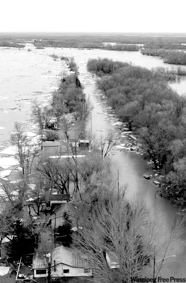
In the Breezy Point area on the west side of the Red River, nine people who declined to heed a voluntary evacuation notice had to be rescued by provincial Zodiac boats.
On the east side of the river, 35 people were evacuated from 27 homes on St. Peters Road North and Peltz Road.
On the south side of the Red River Valley, the community of Riverside (pop. 55), west of Morris, was also being evacuated.
Trouble spots
An ice jam remained Sunday night on the Red River about 2.5 kilometres south of Netley Creek, creating the potential for more flooding.
Provincial steamer crews are still trying to clear culverts in municipalities north of Winnipeg to prevent overland flooding.
Minor flooding is expected on the Assiniboine River from St. Lazare to Griswold, in the Interlake at Peguis First Nation and in the Pembina River Valley from Rock Lake to La Riviere.
As the Red River swells into a lake south of Winnipeg, ring dikes are now partly closed around Emerson, Letellier, St. Jean Baptiste, Morris and St. Adolphe. The dike around Dominion City is also being closed and additional diking is underway at Ste. Agathe.
Not-so-troubled spots
Water levels are expected to drop on the Red River within Winnipeg over the next week. It may rise again as the main Red River crest approaches, but that rise is not expected to pose problems.
Flood facts
As of Sunday morning, the Red River was flowing at a rate of 81,600 cubic feet per second just south of the floodway inlet. That’s roughly equal to one Olympic swimming pool every second.
At the same time, the Red River floodway was carrying 29,300 cubic feet of water per second.
Also on Sunday morning, the Assiniboine River was flowing at a rate of 8,440 cubic feet per second just west of Portage la Prairie. The Portage diversion carried 4,470 cubic feet per second of that flow into Lake Manitoba.
Weather
Rain is expected in Winnipeg today, to about five millimetres and Thursday, while above-average temperatures should melt away most of the city’s remaining snow cover.
Warnings

The City of Winnipeg has asked property owners to leave dikes in place, just in case.
RCMP are asking motorists to slow down and watch for wildlife while driving on Highway 75 south of St. Norbert. Animals are being driven out of their natural habitat because of flooding, said St. Pierre RCMP. Much of Highway 75 is already closed by flooding, but remains open to local traffic from St. Norbert to Highway 205.
Parents and teachers are urged to warn children of the dangers of playing in or near bodies of water, such as rivers, storm water retention ponds (man-made lakes), creeks, streams and ditches. High currents and fast moving, ice-cold water can be extremely dangerous.
— Compiled by Bartley Kives and Nick Martin
— Sources: Province of Manitoba, City of Winnipeg
Related Articles
St. Andrews wins one overnight
Advertisement Advertise With Us
Advertisement Advertise With Us