

Ice chunks jam up the Red in Winnipeg
River level spikes three feet in 24 hours at downtown station
Advertisement
Read this article for free:
or
Already have an account? Log in here »
To continue reading, please subscribe:
Digital Subscription
One year of digital access for only $1.44 a week*
- Enjoy unlimited reading on winnipegfreepress.com
- Read the E-Edition, our digital replica newspaper
- Access News Break, our award-winning app
- Play interactive puzzles
*Billed as $5.77 plus GST every four weeks. After 52 weeks, price increases to the regular rate of $19.95 plus GST every four weeks. Offer available to new and qualified returning subscribers only. Cancel any time.
To continue reading, please subscribe:
Add Free Press access to your Brandon Sun subscription for only an additional
$1 for the first 4 weeks*
- Enjoy unlimited reading on winnipegfreepress.com
- Read the E-Edition, our digital replica newspaper
- Access News Break, our award-winning app
- Play interactive puzzles
*Your next Brandon Sun subscription payment will increase by $1.00 and you will be charged $17.95 plus GST for four weeks. After four weeks, your payment will increase to $24.95 plus GST every four weeks.
Read unlimited articles for free today:
or
Already have an account? Log in here »
Hey there, time traveller!
This article was published 08/04/2011 (5670 days ago), so information in it may no longer be current.
The 2011 flood is already the third-highest deluge in Winnipeg since the completion of the Red River Floodway, as an ice jam at the Redwood Bridge pushed downtown river levels up three feet in 24 hours.
On Thursday evening, the Red River had risen to 20.8 feet above normal winter ice level at the James Avenue monitoring station. That’s high enough to allow this year’s flood to surpass the 2006 flood crest of 20.4 feet James.
The only higher river levels in the post-floodway era took place in 1997 and 2009, when the Red crested at 24.5 feet James and 22.6 feet James, respectively.
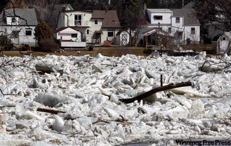
The cause of the spike was an ice jam that materialized near the Redwood Bridge late Wednesday evening, said Grant Mohr, the city’s flood-protection engineer.
Provincial Amphibex icebreakers were on standby for spot duty, but it’s dangerous to deploy them during ice jams, Mohr said.
Farther south along the Red, solid ice at King’s Park drove up river levels all the way to the Red River Floodway. But neither the solid ice nor the ice jams led the city to advise owners of any additional properties to begin building sandbag dikes.
On Thursday, sandbag dikes were nearing completion at 30 properties, although the city was forced to issue another late-afternoon call for volunteers to complete the work.
Sandbag dikes at another 80 properties should be completed by Sunday. Approximately 50,000 sandbags had been delivered as of Thursday, public works flood co-ordinator Scott Payne said.
An additional 450 properties remain on the flood-protection list but the city is holding off on telling those homeowners to build sandbag dikes until river levels rise even higher.
Approximately 500 to 1,000 volunteers will be required to build dikes every day for the next two weeks, said Randy Hull, the city’s emergency preparedness co-ordinator. As of Thursday, 1,125 volunteers had either registered with 311 or were already volunteering. That number includes 400 high school students.
Hull asked volunteers to call 311 so the city can select the properties where help is needed most. The city is also busing in volunteers and arranging services such as portable toilets and food-and-beverage donations.
Out-of-town residents who wish to volunteer in Winnipeg may register at 1-877-311-4974, Hull added.
The Red is expected to crest in Winnipeg somewhere between 20 and 23 feet James. The province will begin operating the Red River Floodway control structure as soon as river ice begins moving freely through its gates, said Steve Topping, Manitoba Water Stewardship’s executive director.
Even without the floodway operating, about 5,500 cubic feet per second of water — roughly 15 per cent of the Red’s flow at Winnipeg — was spilling into the diversion channel on its own Thursday.
bartley.kives@freepress.mb.ca
Latest developments:
Fargo-area flood flight: A 73-year-old man died while sandbagging in Oakport Township, Minn., on Wednesday, the Fargo-Moorhead Forum reported. Meanwhile, U.S. flood forecasters downgraded the Red River crest at Fargo. The National Weather Service expects the Red to crest at 30 to 40 feet at Fargo on Sunday, down from a previous crest range of 39 to 40 feet. Fargo-Moorhead is protecting against a 42-foot crest.

Red River Valley in Manitoba: Manitoba Water Stewardship started preparing to close the ring dike at Brunkild. Ring-dike closures are also underway at Ste. Agathe and St. Adolphe.
Red River in Winnipeg: An ice jam at the Redwood Bridge drove the Red River up to 20.8 feet James on Thursday evening, which is above the 2006 flood crest. Solid ice south of King’s Park is also driving up river levels in southern Winnipeg. But no additional properties were threatened by the rising river levels. Work continued on sandbag dikes at 110 low-lying Winnipeg properties. The city still needs volunteers to help build dikes and is asking people to register at 311.
Elsewhere in Manitoba: An ice jam on the Souris River is driving up levels near Melita, but the river remains within its banks. The Assiniboine River has been slow to rise. Overland flooding exists around Elm Creek, 50 kilometres west of Winnipeg.
— Kives