

Where all that water is going — and how
Advertisement
Read this article for free:
or
Already have an account? Log in here »
To continue reading, please subscribe:
Digital Subscription
One year of digital access for only $1.44 a week*
- Enjoy unlimited reading on winnipegfreepress.com
- Read the E-Edition, our digital replica newspaper
- Access News Break, our award-winning app
- Play interactive puzzles
*Billed as $5.77 plus GST every four weeks. After 52 weeks, price increases to the regular rate of $19.95 plus GST every four weeks. Offer available to new and qualified returning subscribers only. Cancel any time.
To continue reading, please subscribe:
Add Free Press access to your Brandon Sun subscription for only an additional
$1 for the first 4 weeks*
- Enjoy unlimited reading on winnipegfreepress.com
- Read the E-Edition, our digital replica newspaper
- Access News Break, our award-winning app
- Play interactive puzzles
*Your next Brandon Sun subscription payment will increase by $1.00 and you will be charged $17.95 plus GST for four weeks. After four weeks, your payment will increase to $24.95 plus GST every four weeks.
Read unlimited articles for free today:
or
Already have an account? Log in here »
Hey there, time traveller!
This article was published 19/04/2011 (5542 days ago), so information in it may no longer be current.
As the flood of 2011 spreads across more of Manitoba, Winnipeggers may wonder how the provincial capital remains so high and dry.
The answer involves the co-ordinated use of three flood-mitigation measures completed four decades ago: The Red River Floodway east of Winnipeg, the Portage Diversion west of Portage la Prairie and the Shellmouth Dam and Reservoir north of Russell.
Thanks to all three, the flood threat for Winnipeg actually subsided on Monday, as flows on the Assiniboine River within the city subsided by approximately 40 per cent since Sunday and flows on the Red River remained static within the city.
Here’s how the flood-mitigation measures work:
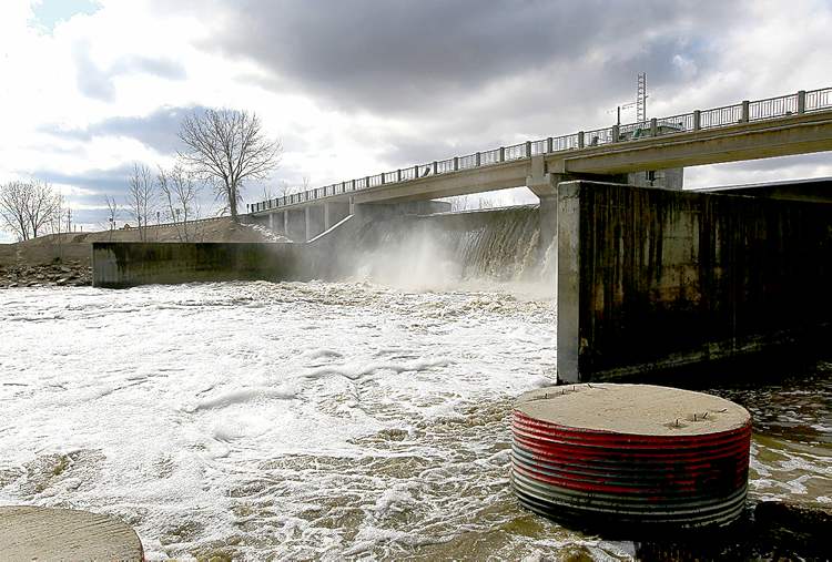
Red River Floodway
Completed: 1968 for $63 million; expansion completed in 2009 for $665 million.
How it works: The floodway diverts part of the Red River’s flow at Winnipeg around the east side of the city through a channel that re-enters the river at Lockport. A control structure at the Courchaine Bridge in St. Norbert allows gates to be raised, forcing water over a spillway and into the diversion channel.
Flood mitigation: The expanded floodway can handle 140,000 cubic feet of water per second (CFS), which is roughly equal to the entire flow of the Red River south of Winnipeg at the peak of the 1997 “Flood of the Century.”
On Monday: The Red’s flow was 59,000 cubic feet per second south of Winnipeg. Of that, 23,000 CFS was diverted into the floodway while the remaining 36,000 CFS entered Winnipeg.
Portage Diversion
Completed: 1970 for $20.5 million
How it works: The diversion sends part of the Assiniboine River’s flow southwest of Portage la Prairie north to Lake Manitoba instead of allowing it to continue east toward the Red River at Winnipeg.
Flood mitigation: As much as 25,000 cubic feet per second can be diverted to Lake Manitoba.
On Monday: The Assiniboine’s flow was 26,400 cubic feet per second west of Portage la Prairie. Of that, 20,300 CFS was diverted to Lake Manitoba, with the remaining 6,100 CFS flowing toward Winnipeg.
Shellmouth Dam & Reservoir
Completed: 1972 for $10.8 million
How it works: The Shellmouth Dam on the Assiniboine River can hold back flows from the upper Assiniboine drainage area, most of which sits inside Saskatchewan. The resulting man-made lake is called Lake of the Prairies. Manitoba Water Stewardship draws down the reservoir before floods to create more capacity in the reservoir, which is designed to spill over the lip of the dam when the lake level reaches 1,408.5 feet above sea level.
Flood mitigation: The reservoir can hold back most of the Assiniboine River’s flow until it fills. Typically, 400 CFS is released at all times.
On Monday: Approximately 6,560 CFS was flowing into the reservoir, with 480 CFS being released downstream. Lake of the Prairies rose to 1,390.4 feet above sea level.
— Bartley Kives

More at winnipegfreepress.com
— FLOOD CAMS: Check out our nine live river cameras
— MAP: See flooding trouble spots, and add your own
— YOUR VIEW: Reader-submitted flood photos
— VIDEO: Flood update and Flood danger demo