

Emerson crest ‘inconvenient’
Town diked up, mayor unfazed
Advertisement
Read this article for free:
or
Already have an account? Log in here »
To continue reading, please subscribe:
Monthly Digital Subscription
$1 per week for 24 weeks*
- Enjoy unlimited reading on winnipegfreepress.com
- Read the E-Edition, our digital replica newspaper
- Access News Break, our award-winning app
- Play interactive puzzles
*Billed as $4.00 plus GST every four weeks. After 24 weeks, price increases to the regular rate of $19.95 plus GST every four weeks. Offer available to new and qualified returning subscribers only. Cancel any time.
Monthly Digital Subscription
$4.99/week*
- Enjoy unlimited reading on winnipegfreepress.com
- Read the E-Edition, our digital replica newspaper
- Access News Break, our award-winning app
- Play interactive puzzles
*Billed as $19.95 plus GST every four weeks. Cancel any time.
To continue reading, please subscribe:
Add Free Press access to your Brandon Sun subscription for only an additional
$1 for the first 4 weeks*
*Your next subscription payment will increase by $1.00 and you will be charged $16.99 plus GST for four weeks. After four weeks, your payment will increase to $23.99 plus GST every four weeks.
Read unlimited articles for free today:
or
Already have an account? Log in here »
Hey there, time traveller!
This article was published 26/04/2011 (5474 days ago), so information in it may no longer be current.
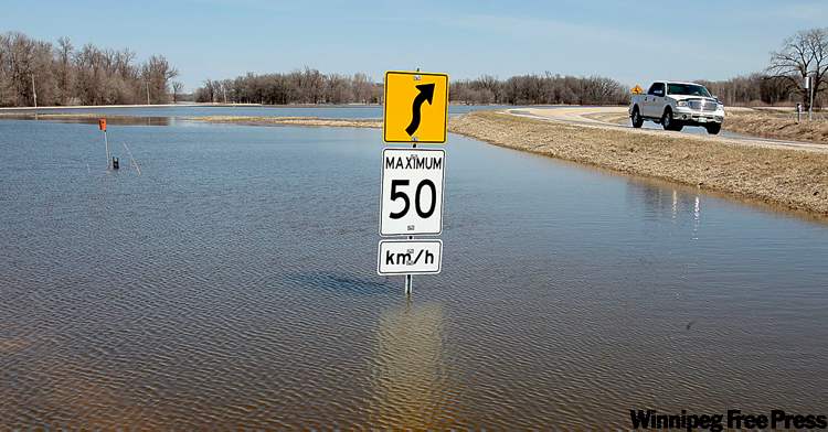
EMERSON — The crest of the Red River has reached the Manitoba border along with the palpable sense that flood fighters have a handle on the variables in what has been an unpredictable province-wide deluge.
On Monday, the Red flowed past the well-fortified town of Emerson at a rate of 83,000 cubic feet per second, the equivalent of an Olympic swimming pool rushing by with every tick of the clock.
That’s roughly the same crest Emerson experienced in the 2009 spring flood and a far cry from the 145,000 cfs that rushed past the border town in 1997, when Canadian soldiers worked frantically to raise the community’s ring dike.

“This is more of an inconvenience,” Emerson Mayor Wayne Arseny said, summing up a 2011 flood that has hampered business at the duty-free store and submerged a cemetery outside the town’s ring dike but has otherwise not affected the day-to-day lives of his constituents. “After so many floods, you get used to it.”
Arseny’s matter-of-fact demeanour is typical in the Red River Valley, where flood-hardened municipalities have had no need to declare states of emergency this year.
A similar calm is starting to spread across western Manitoba, where most of the Assiniboine River’s tributaries have crested, allowing provincial flood fighters to make more confident predictions about the rest of the flood season.
“We know how much water is in the system, what volumes we’re dealing with and, with the flood-control infrastructure, we’ll be able to manage it now,” said Steve Topping, Manitoba Water Stewardship’s executive director.
The Red in Winnipeg is expected to crest no higher than 21.3 feet above the normal winter ice level at James Avenue. That allowed Winnipeg flood-protection engineer Grant Mohr to call off the city’s final round of sandbag-dike construction.
Flows on the Assiniboine are no longer expected to threaten any cities or towns, but farmland will be submerged, hampering farmers’ seeding.
Water levels on the Red and Assiniboine will remain high until June, extending the time Winnipeg is prone to basement flooding. Heavy rains have the potential to overwhelm the city’s drainage system when water levels are high.
Provincial officials believe the flooding situation would be much worse without Manitoba’s three major flood-mitigation structures — the Shellmouth Dam and Reservoir north of Russell, the Portage Diversion west of Portage la Prairie and the Red River Floodway at Winnipeg.
“If this was pre-1997, you would be seeing upwards of 10 feet of additional water levels in the rivers within Winnipeg,” Emergency Measures Organization Minister Steve Ashton said Monday.
Without the Shellmouth Dam holding back upper Assiniboine flows in Lake of the Prairies, water levels would be two feet higher at Brandon. The reservoir, however, has almost reached its capacity and is expected to spill over the dam within days.
Topping said Shellmouth outflows will be increased to manage the storage capacity of Lake of the Prairies.
The Portage Diversion is channelling slightly more than two-thirds of the lower Assiniboine’s flow into Lake Manitoba instead of farther east to Winnipeg. On Monday, the diversion sent 25,000 cubic feet per second of water into Lake Manitoba, while 11,000 cfs headed to Winnipeg.
The Red River Floodway is sending just under half the Red’s flow around Winnipeg. On Monday, 31,000 cfs of water entered the floodway, while 41,000 cfs flowed in the river.
bartley.kives@freepress.mb.ca bruce.owen@freepress.mb.ca
WATCHING THE WATER: Flood update
— Evacuees: Flooding throughout the province has displaced 1,772 people, mostly from Roseau River Anishinabe First Nation in the Red River Valley and Peguis First Nation on the Fisher River in the Interlake.
— Road closures: 79 provincial roads are affected by flooding and 53 of them are closed. About 600 municipal roads are closed due to flooding.

— Souris River: Dropping in Melita, cresting in Souris and expected to crest in Wawanesa within days.
— Assiniboine River: Expected to spill over the Shellmouth Dam within days. Already crested at St-Lazare. Will crest in Brandon between April 29 and May 3.
— Red River: Expected to crest at Letellier today. Will crest in Winnipeg between May 1 and 4.
— The Pas: Ice jams have cleared on the Saskatchewan and Carrot rivers, which have both dropped, eliminating the flood risk.
— Lake Winnipeg: Water levels forecast to be high this year. The water level at Gimli was 715.21 feet Monday. Lake Winnipeg is forecast to be 716 in June.
Related Articles
Red crest nears Letellier
Advertisement Advertise With Us
Advertisement Advertise With Us