

How the dike will be cut
Advertisement
Read this article for free:
or
Already have an account? Log in here »
To continue reading, please subscribe:

Digital Subscription
One year of digital access for only $205*
- Enjoy unlimited reading on winnipegfreepress.com
- Read the E-Edition, our digital replica newspaper
- Access News Break, our award-winning app
- Play interactive puzzles
*First annual payment billed as $205.00 + GST for one year. This annual subscription will automatically renew at $233.00 + GST every 52 weeks (10% off the regular annual price of $259.35). Offer available to new and qualified returning subscribers only. Cancel any time.
To continue reading, please subscribe:
Add Free Press access to your Brandon Sun subscription for only an additional
$1 for the first 4 weeks*
- Enjoy unlimited reading on winnipegfreepress.com
- Read the E-Edition, our digital replica newspaper
- Access News Break, our award-winning app
- Play interactive puzzles
*Your next Brandon Sun subscription payment will increase by $1.00 and you will be charged $17.95 plus GST for four weeks. After four weeks, your payment will increase to $24.95 plus GST every four weeks.
Read unlimited articles for free today:
or
Already have an account? Log in here »
Hey there, time traveller!
This article was published 11/05/2011 (5543 days ago), so information in it may no longer be current.
As early as noon today, the province will cut a hole in Provincial Road 331 southeast of Portage la Prairie to release flood water from the Assiniboine River.
Here’s how they will do it:
Heavy machinery will cut a 65-metre-wide channel in the road near an oxbow in the river. An oxbow is a former section of river channel that’s been cut off by channel erosion. But with the Assiniboine rising, the oxbow has filled up with water.
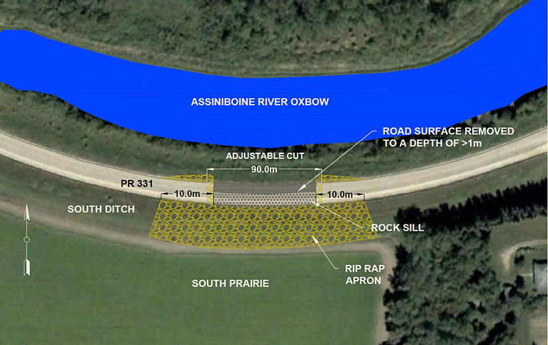
Crews will leave one-quarter of the road in place, to be taken out quickly when needed.
They will then fill in the open area with rock to act as a temporary dam.
When needed, the rock will be removed and the rest of the road taken out to release water from the Assiniboine.

Rock will be put back in to close it off once enough water has been released.
Enough rock is being hauled to the site to make sure the “notch” does not become an uncontrolled breach.


Advertisement Advertise With Us