

Flood choices under debate
Hoop and Holler cut decision questioned
Advertisement
Read this article for free:
or
Already have an account? Log in here »
To continue reading, please subscribe:
Digital Subscription
One year of digital access for only $1.44 a week*
- Enjoy unlimited reading on winnipegfreepress.com
- Read the E-Edition, our digital replica newspaper
- Access News Break, our award-winning app
- Play interactive puzzles
*Billed as $5.77 plus GST every four weeks. After 52 weeks, price increases to the regular rate of $19.95 plus GST every four weeks. Offer available to new and qualified returning subscribers only. Cancel any time.
To continue reading, please subscribe:
Add Free Press access to your Brandon Sun subscription for only an additional
$1 for the first 4 weeks*
- Enjoy unlimited reading on winnipegfreepress.com
- Read the E-Edition, our digital replica newspaper
- Access News Break, our award-winning app
- Play interactive puzzles
*Your next Brandon Sun subscription payment will increase by $1.00 and you will be charged $17.95 plus GST for four weeks. After four weeks, your payment will increase to $24.95 plus GST every four weeks.
Read unlimited articles for free today:
or
Already have an account? Log in here »
Hey there, time traveller!
This article was published 19/03/2012 (5194 days ago), so information in it may no longer be current.
One of the criticisms of the provincial government in last year’s flood is that it may have been too cautious.
In 1969, the last Assiniboine River flood before the Portage Diversion came into operation, 22,000-cubic-feet-per-second of water flowed down the stretch of river between Portage la Prairie and Elie.
In 1976, another high-water year, 24,000 cfs flowed.
In 2011, the biggest flood of them all, the province ran just 18,000 cfs down the Assinboine River.
The reduced flow along the lower Assiniboine River in 2011 meant more water had to be dumped into Lake Manitoba and Lake St. Martin.
Did the government act too cautiously in last year’s flood, as some critics claim, including people from within the government’s own flood-fighting department?
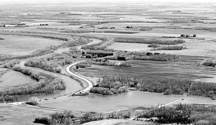
In addition, the province decided to cut the dike at the Hoop and Holler Bend just southeast of Portage. That removed just 300 cfs out of the Assiniboine River — the equivalent of about an inch on the river. In other words, if the government hadn’t made the cut at Hoop and Holler, it would have raised the Assiniboine downstream by just an inch.
Why did the government even bother to cut the Hoop and Holler at that point? Sure, it was nice to be prepared in case there was another giant rainstorm. But that didn’t happen. Then why proceed to cut the dike to prevent the Assiniboine River from rising a mere inch?
There’s more to the story. In March 2011, with time to prepare for a flood everyone knew was coming, the province spent $20 million to build a temporary earthen dike along the Assiniboine between Portage and Elie.
And what happened to that dike? It wasn’t used. Not even to take that extra inch.
Perhaps these questions will be answered more thoroughly in one of the four reviews the government has called into its handling of the 2011 flood. In talks with several government officials, and with several insiders who did not want their names used, a handful of reasons came back.
First, it’s a misconception that the $20-million dike built along the Assiniboine River was about protecting Winnipeg. If that dike had been breached, water would have funnelled back into the Assiniboine’s banks farther downstream before it reached Winnipeg. A breach on the north side of the Assiniboine would, in short, have flooded farmland and potentially homes around Headingley, and a breach to the south would have threatened farms and Elie, which were heavily fortified by diking.
The $20-million dike was built to the 1976 flood level, plus two feet. Essentially, it was filling in the low spots along that 70-kilometre stretch between Portage and Elie. A similar dike was built there in 1976 when there was much less time. It was constructed in a mad rush that was something like construction of the Z-dike in the 1997 Red River flood.
The main reason the $20-million dike was hardly used, except for some low spots, government says, is it contained too many ice chunks that could melt and cause the dike to break.
That’s challenged by some insiders who say Manitoba Infrastructure and Transportation didn’t build the dike properly. When a dike is built, crews must dig three to four feet down to get to the mud beneath the frozen ground. This wasn’t done. Then the crews scrape vegetation off the top of the existing permanent dike and drop the new, unfrozen earth on top. They will bind together even if the existing dike is still frozen.
Dikes have been built along the Red River in February that worked perfectly well. “They had no clue what to do,” said one insider about Manitoba Infrastructure and Transportation.
The province disagrees. What critics don’t realize is this was a different kind of flood, said Eugene Kozera, the province’s director of water control systems. Manitoba’s flood fighters never made the effort to keep out frozen earth because the province believed a partly frozen dike would suffice for two to three weeks of spring flooding. It was when the flood lasted into the warmer temperatures of June and July that provincial experts realized the dike made with frozen material was useless. They just didn’t anticipate that kind of flood, Kozera said.
In addition, the existing permanent dikes were in bad shape, said Steve Topping, Manitoba’s head flood fighter. Topping said the province put up to 19,000 cfs into the Assiniboine and saw too many structural problems on the old dikes. The Assiniboine has sandier soil that doesn’t bind like Red River gumbo. KGS Engineering studied the strength of the Assiniboine dikes and it identified 16 problem sites.
Critics dismiss the seepage problems as gopher holes that can be found in all permanent dikes. Patching is required on all dikes once water comes against them.
As well, partly frozen earth was also used to build temporary dikes along the Portage Diversion. It was a very tense time, with much seepage and repair work. But those dikes withstood the force of 34,000 cfs charging down its 30-kilometre length. That’s 9,000 cfs more than the diversion’s capacity. It makes the 18,000 cfs that flowed down the Assiniboine east of Portage look like a trickle by comparison.
Topping responded that those existing dikes along the Portage Diversion were newer and in better shape.
If the government had let 24,000 cfs flow down the Assiniboine, it would have added roughly a foot to the river’s height, perhaps up to 18 inches in some places. By channelling it through the Portage Diversion, it added about a foot of water to Lake Manitoba. An extra foot of water on that already bloated lake can wreak a lot of damage. People living along Lake Manitoba and Lake St. Martin have a right to wonder whether protection along the Assiniboine took precedence over their areas.
But even if the government is taken at it word, there’s still the matter of the one-inch decision. The cutting of the Hoop and Holler was delayed several times. There was great anticipation. National media reported on it for days. Did the dike need to be cut?
One government staffer said it had to be cut because the province couldn’t predict the flow on the Assiniboine. Flood experts didn’t know what was coming from the Souris River, which joins with the Assiniboine at Spruce Woods Provincial Park about 90 kilometres southwest of Portage.
This sounds odd. There’s a river gauge at Brandon for the Assiniboine River, and there’s a another gauge at Wawanesa for the Souris River. Add the two. There’s your water level where the two rivers meet.
Looked at another way, from Brandon, you have three to four days before the river’s crest reaches the Hoop and Holler. If that gauge at Brandon tells you too much water is coming, and if the Town of Souris is hit by water levels that were feared but which never arrived, then by all means, cut the dike at Hoop and Holler.

There is even a gauge at Highway 34, east of the confluence of the Souris and Assiniboine rivers, that measures water levels almost two days before they reach Portage.
Instead, the government wouldn’t hazard water levels rising even one inch against its pristine, unused dike.
“We got a peak flow of 52,300 cfs at 4 a.m. (on May 14),” said Topping. (The Portage Diversion was to take 34,000 cfs and the Assiniboine 18,000 cfs, for a total of 52,000.) “I was advised it had crossed the threshold of 52,000 cfs and at 7 a.m. we started opening the Hoop and Holler.”
“That’s the straw that would have broken the camel’s back,” Topping maintained.
bill.redekop@freepress.mb.ca