

Sandbag dikes in city as Red swells
Floodway gates raised to protect low-lying areas
Advertisement
Read this article for free:
or
Already have an account? Log in here »
To continue reading, please subscribe:
Monthly Digital Subscription
$1 per week for 24 weeks*
- Enjoy unlimited reading on winnipegfreepress.com
- Read the E-Edition, our digital replica newspaper
- Access News Break, our award-winning app
- Play interactive puzzles
*Billed as $4.00 plus GST every four weeks. After 24 weeks, price increases to the regular rate of $19.95 plus GST every four weeks. Offer available to new and qualified returning subscribers only. Cancel any time.
Monthly Digital Subscription
$4.99/week*
- Enjoy unlimited reading on winnipegfreepress.com
- Read the E-Edition, our digital replica newspaper
- Access News Break, our award-winning app
- Play interactive puzzles
*Billed as $19.95 plus GST every four weeks. Cancel any time.
To continue reading, please subscribe:
Add Free Press access to your Brandon Sun subscription for only an additional
$1 for the first 4 weeks*
*Your next subscription payment will increase by $1.00 and you will be charged $16.99 plus GST for four weeks. After four weeks, your payment will increase to $23.99 plus GST every four weeks.
Read unlimited articles for free today:
or
Already have an account? Log in here »
Hey there, time traveller!
This article was published 30/04/2013 (4711 days ago), so information in it may no longer be current.
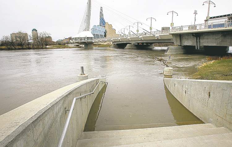
Sandbag dikes went up around seven Winnipeg properties at the city’s southern extremes late Monday as a precaution against the Red River’s belated but swift rise.
Winnipeg flood planners recommended the construction of sandbag dikes around seven properties on Christie Road in South St. Vital and Cloutier Drive in St. Norbert due to water levels that rose to nearly 16 feet above normal winter ice level at the James Avenue monitoring station at 6 p.m.
At the same hour, the province raised the gates at the Red River Floodway control structure in order to begin diverting flows into the floodway channel and mitigate against further river-level increases within the city.
Another 11 low-lying properties in Winnipeg’s south end have been placed on standby for sandbag-dike construction in the event water levels continue to rise. But the rise of the Red River within the city is expected to slow by the evening at the latest, said Grant Mohr, Winnipeg’s flood-planning engineer.
“By (Tuesday) we’ll be able to see the effects of the floodway operation,” Mohr said.
It is unusual for the province to operate the floodway while Assiniboine River levels are so low, Mohr said. But the fast rise of the Red River made it necessary to protect properties at the south end of the city, he added.
There also appears to be a problem with the river-level gauge at the James Avenue monitoring station, suggesting river levels in the city may actually be higher than they appear, Mohr said.
But he said he does not believe the Red will crest higher than 19 feet James in Winnipeg this flood season. That’s down from a worst-case scenario of 20.5 feet project earlier in April.
“We’re in pretty good shape right now,” he said, characterizing the erection of sandbag dikes as a precaution.
In recent years, the construction of permanent clay dikes at perennially troublesome low-lying properties, such as the La Salle Hotel on Nairn Avenue, have reduced the total number of temporary sandbag dikes that must be built during floods. Earlier this month, when the flood forecast was slightly more ominous, the city estimated no more than 26 properties may require sandbag dikes this season.
The primary threat to Winnipeg properties over the coming weeks is not the city’s rivers, but the possibility of sewer backups during heavy rains, Mohr said. Since gates connecting the city’s combined sewers to its rivers are shut when water levels are high, there’s an increased risk of sewer backups in the event stormwater runoff exceeds the capacity of the pumps responsible for sending rain-diluted sewage towards the city’s three wastewater-treatment plants.
Outside Winnipeg’s borders, most of the Red’s smaller tributaries have started to recede, Manitoba Conservation and Water Stewardship said in a daily flood bulletin. Water levels are continuing to rise on the Assiniboine River, where the Portage Diversion was slated to begin operating due to the ice-jam threat east of Portage la Prairie. Levels also rose dramatically on the Pembina River, which flows into the Red south of the U.S. border.

The U.S. National Weather Service now predicts a 50.2-foot Red River crest at Pembina, N.D., which would rank as the sixth-highest crest on record at the Canada-U.S. border. But south of the confluence of the Pembina River, the flood threat on the Red River had been downgraded significantly.
The U.S. weather office’s hydrologic prediction service now expects the Red to crest at 45.5 feet at Grand Forks, which would only rank as the 14th-highest crest on record.
And the Red River’s crest at Fargo, expected Wednesday, has been downgraded to 35.5 feet, which would be the ninth-largest flood on record.
Earlier this flood season, Fargo was preparing for the possibility of a crest as much as two feet above the record level of 40.84 feet, set in 2009. That receded after weeks of helpful weather.
bartley.kives@freepress.mb.ca
Related Articles
Diversion protest 'irresponsible': province
Advertisement Advertise With Us
Advertisement Advertise With Us