

Canada’s newest eyes in sky on Red River flood watch
Advertisement
Read this article for free:
or
Already have an account? Log in here »
To continue reading, please subscribe:
Monthly Digital Subscription
$1 per week for 24 weeks*
- Enjoy unlimited reading on winnipegfreepress.com
- Read the E-Edition, our digital replica newspaper
- Access News Break, our award-winning app
- Play interactive puzzles
*Billed as $4.00 plus GST every four weeks. After 24 weeks, price increases to the regular rate of $19.95 plus GST every four weeks. Offer available to new and qualified returning subscribers only. Cancel any time.
Monthly Digital Subscription
$4.99/week*
- Enjoy unlimited reading on winnipegfreepress.com
- Read the E-Edition, our digital replica newspaper
- Access News Break, our award-winning app
- Play interactive puzzles
*Billed as $19.95 plus GST every four weeks. Cancel any time.
To continue reading, please subscribe:
Add Free Press access to your Brandon Sun subscription for only an additional
$1 for the first 4 weeks*
*Your next subscription payment will increase by $1.00 and you will be charged $16.99 plus GST for four weeks. After four weeks, your payment will increase to $23.99 plus GST every four weeks.
Read unlimited articles for free today:
or
Already have an account? Log in here »
Hey there, time traveller!
This article was published 20/04/2020 (2163 days ago), so information in it may no longer be current.
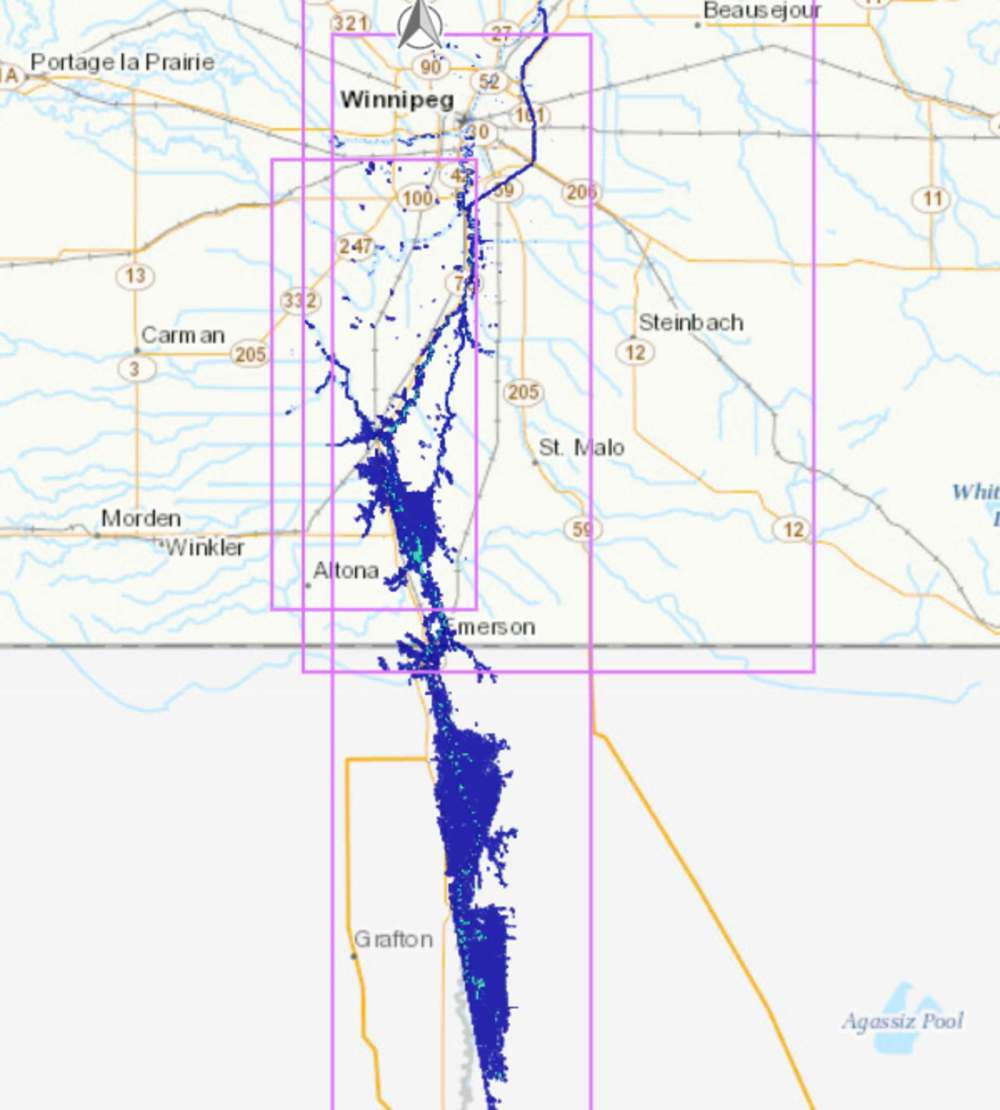
The Canadian Space Agency’s newest radar satellites are transmitting flood data — and their first test is in the Red River Valley.
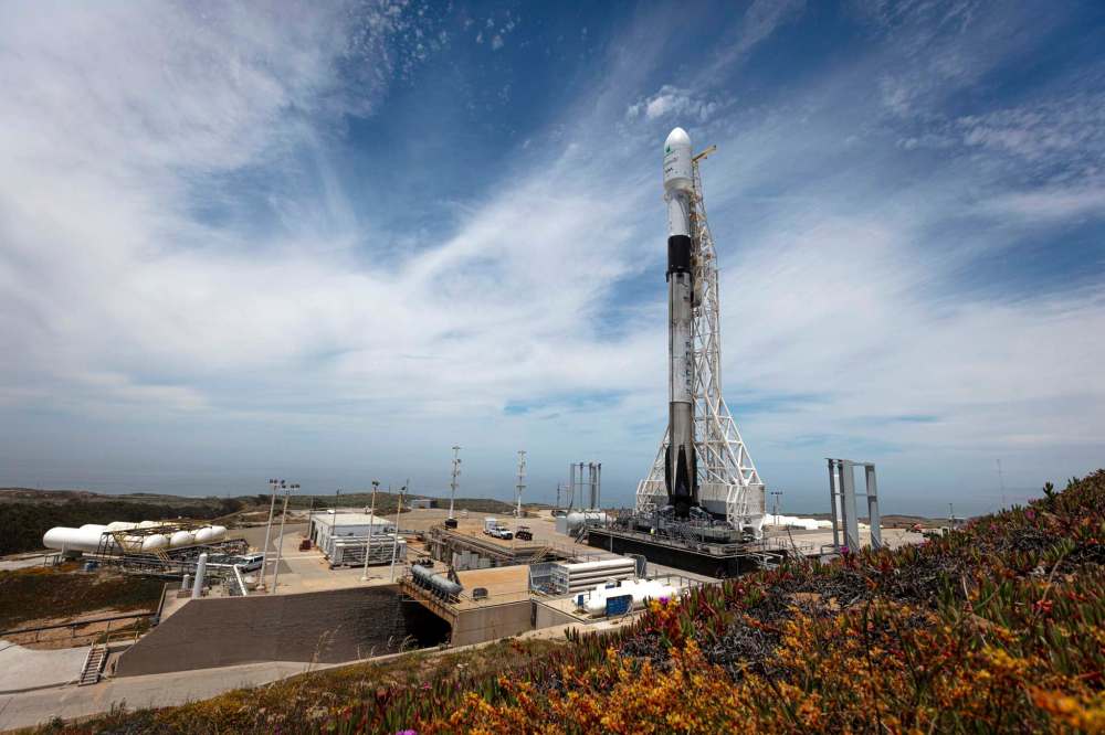
Three 1,430-kilogram satellites were launched by U.S.-based SpaceX on a Falcon 9 rocket in June 2019. Months were needed to calibrate the satellites, which are part of CSA’s RADARSAT Constellation Mission (thus known as RCM satellites).
They mark the country’s third generation of radar satellites.
“Because the satellites launched at the same time, they needed time to be able to spread across the Earth. It took about two weeks for the satellites to enter their proper orbits. Because they circulate on the same orbit, but they chase each other, so they are about 30 minutes apart,” Daniel De Lisle, RCM mission manager, told the Free Press by phone from CSA headquarters in Quebec.
On Dec. 19, the trio of RCM satellites were declared operational and began providing information to a dozen Canadian federal departments. The 2020 spring melt and rising waters of the Red River offered the first chance to test out the new equipment in an emerging flood situation.
“We can provide about 170 different types of imagery from those satellites, so we can have very small precision, looking at things as small as one metre, or we can have very broad images,” De Lisle said.
Previously, the space agency’s capabilities were limited to a single satellite that transmitted targeted information with a greater time delay, sometimes two to 12 days. The new satellites travel at a speed of 27,200 km/h, passing around the Earth once every 96 minutes. Information is transmitted and updated daily, if not more often.
Roger De Abreu, acting director of the Canada Centre for Remote Sensing (a division of Natural Resources Canada) says when it comes to emergency response situations, the change in the flow of information is invaluable.
“That’s a tremendous improvement. When you’re trying to measure something as fast-moving as a flood, you want to provide as much current and frequent information as possible,” De Abreu said.
“It means a lot to those downstream, to the people who are trying to build a situational awareness of the flood, at the federal level, but also at the provincial level. Also to those responders who are trying to marshal resources.”
The satellite trio is also contributing to Canada’s commitment to the International Charter Space and Major Disasters co-operative agency, which represents the combined efforts of 17 member countries and 61 satellites tracking and monitoring disasters. Natural Resources Canada will also be using information from the satellites to improve national flood-plain mapping and understanding of flood risks.
Numerous federal agencies and researchers benefit from the data the RCM satellites provide; Agriculture Canada uses it to analyze crops, the Department of National Defence uses it to track ships.
Also, a large part of knowledge about how the country is evolving due to climate change is informed by these radar satellites, monitoring everything from how vegetation is changing to creeping permafrost thaw.
“Canada’s radar satellites are really good at measuring, from space, changes in the Earth’s subsidence or deformation, as it rises and falls on the scale of millimetres or centimetres. So one thing that happens with permafrost is that as the top layer of the permafrost melts and freezes every year, there’s a heaving that goes on, and that’s important to understand when you’re building (structures) and whatnot,” De Abreu said.

In a country as large as Canada, there would be no other way to effectively monitor changes across the land mass without leveraging off the CSA and its technology.
“You can’t effectively manage something if you can’t see it,” De Abreu said. “All decisions require a degree of environmental intelligence — understanding what your country is today, what it was in the past, and where it’s going in the future — and the ability to tap into satellites that are crossing this country every day is important to that. It’s critical.”
sarah.lawrynuik@freepress.mb.ca
Twitter: @SarahLawrynuik