

City asks Wolseley residents for input on new bike route

Advertisement
Read this article for free:
or
Already have an account? Log in here »
To continue reading, please subscribe:

Digital Subscription
One year of digital access for only $205*
- Enjoy unlimited reading on winnipegfreepress.com
- Read the E-Edition, our digital replica newspaper
- Access News Break, our award-winning app
- Play interactive puzzles
*First annual payment billed as $205.00 + GST for one year. This annual subscription will automatically renew at $233.00 + GST every 52 weeks (10% off the regular annual price of $259.35). Offer available to new and qualified returning subscribers only. Cancel any time.
To continue reading, please subscribe:
Add Free Press access to your Brandon Sun subscription for only an additional
$1 for the first 4 weeks*
- Enjoy unlimited reading on winnipegfreepress.com
- Read the E-Edition, our digital replica newspaper
- Access News Break, our award-winning app
- Play interactive puzzles
*Your next Brandon Sun subscription payment will increase by $1.00 and you will be charged $17.95 plus GST for four weeks. After four weeks, your payment will increase to $24.95 plus GST every four weeks.
Read unlimited articles for free today:
or
Already have an account? Log in here »
Hey there, time traveller!
This article was published 12/11/2018 (2802 days ago), so information in it may no longer be current.
In a part of Winnipeg renowned for its environmental friendliness, a bike route shouldn’t be a hard sell. Still, residents of Wolseley are being asked by the city about what they’d like to see.
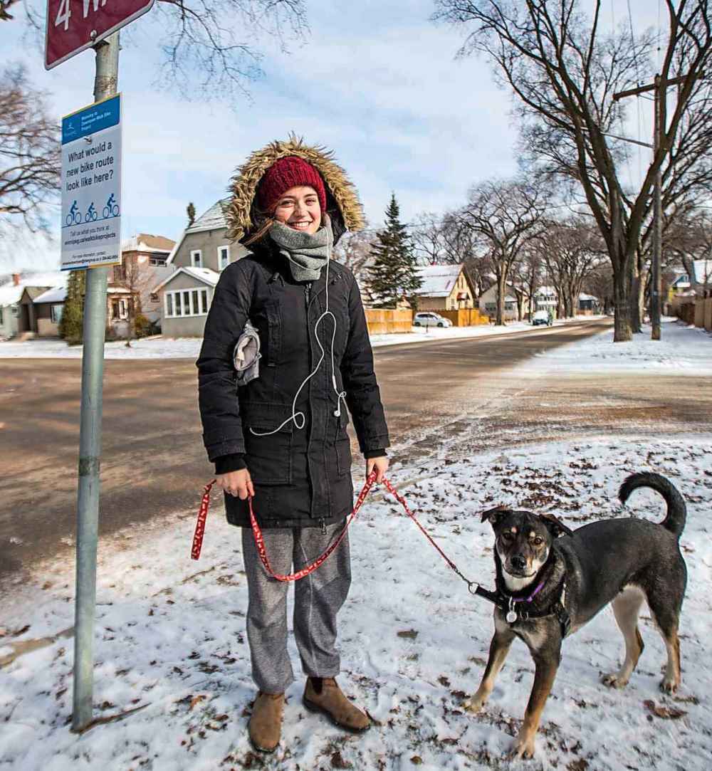
“What would a new bike route look like here?” ask new Wolseley to Downtown Walk Bike Project signs posted by the city last week on Wolseley Avenue. They ask passersby to “tell us what you think.”
Area resident Elena Howard-Scott likes the idea of Wolseley Avenue having a lane for bikes.

“I think it’ll increase accessibility,” said Howard-Scott, who was walking her dog Ziggy in the area on Monday. The student who works said it might even persuade her to get back to riding her bicycle in the city.
Cindy Gilroy, councillor for the area, said the goal is to make the traffic situation better for everyone, whether they’re walking, biking or driving.
“What we are doing is a greenway study looking at all modes of transportation on both Wolseley and Westminster,” said Gilroy. “It’s about finding ways we can all make sure that holistically we can live together with active transportation or driving a car,” said Gilroy, who was reelected Oct. 24 in Daniel McIntyre.
“Traffic’s been a big issue in Wolseley,” she said. “It’s been pretty crazy,” said the councillor, who heard area residents’ complaints about it when she was campaigning door to door. She said the idea for the yellow and blue Please Slow Down lawn signs that she gives to people in her ward who request them ward came from a Wolseley resident who wanted to see traffic calming measures taken.
“How do we reduce traffic?” asked Gilroy. She said “traffic-calming” measures and active transportation can help.
“It could be a variety of many different things,” she said, including making some residential streets one-way streets to cut down on cut-through traffic.
“We do see a lot of cut-through traffic,” as more and more motorists use residential side streets to get where they’re going rather than main traffic corridors, she said. The afternoon rush hour is especially bad, Gilroy said. “It’s piled up” with drivers trying to get onto the Maryland Bridge.
The traffic on Wolseley Avenue is especially frustrating on Sundays in the summer when it is supposed to be closed to through traffic, said Shelagh Weedon. She’s lived in the area for nearly 30 years and said it’s not safe for her to walk her dogs on summer Sundays on the Wolseley Avenue roadway because so many drivers ignore the signs saying it’s closed to through traffic from dawn until dusk. She wondered what effect a bike lane there would have on vehicular traffic. “I’d like more clarification,” said Weedon, who planned to find out more online.

“This is the first phase in public engagement,” said Mark Cohoe, executive director of Bike Winnipeg. The advocacy group presents background information and bike-friendly recommendations to as many government agencies and related organizations as it can manage with its limited resources.
“What they’re looking at is connections through Wolseley from Empress (Street) and Omand Park all the way through to Osborne Street and Assiniboine Avenue.” There’s an online survey Winnipeggers can take about the Wolseley to Downtown Walk Bike project and opportunities to meet the planners in person at different times and locations in the neighbourhood. Even though it’s almost winter, Cohoe expects the city will receive a lot of public feedback from Wolseley residents.
“The good thing about that neighbourhood is there’s a lot of people who cycle in that area of the city,” he said. “It has the highest cycling rates.”
In 2018, the city budgeted $250,000 for preliminary design of bike routes along Wolseley and Westminster avenues.
carol.sanders@freepress.mb.ca
Wolseley bike route study area
Carol Sanders
Legislature reporter
Carol Sanders is a reporter at the Free Press legislature bureau. The former general assignment reporter and copy editor joined the paper in 1997. Read more about Carol.
Every piece of reporting Carol produces is reviewed by an editing team before it is posted online or published in print — part of the Free Press‘s tradition, since 1872, of producing reliable independent journalism. Read more about Free Press’s history and mandate, and learn how our newsroom operates.
Our newsroom depends on a growing audience of readers to power our journalism. If you are not a paid reader, please consider becoming a subscriber.
Our newsroom depends on its audience of readers to power our journalism. Thank you for your support.
For more information
Members of the public are invited to get more information at winnipeg.ca/walkbikeprojects and to contact or call 204-942-0654
Carol Sanders
Legislature reporter
Carol Sanders is a reporter at the Free Press legislature bureau. The former general assignment reporter and copy editor joined the paper in 1997. Read more about Carol.
Every piece of reporting Carol produces is reviewed by an editing team before it is posted online or published in print — part of the Free Press‘s tradition, since 1872, of producing reliable independent journalism. Read more about Free Press’s history and mandate, and learn how our newsroom operates.
Our newsroom depends on a growing audience of readers to power our journalism. If you are not a paid reader, please consider becoming a subscriber.
Our newsroom depends on its audience of readers to power our journalism. Thank you for your support.
Advertisement Advertise With Us
Advertisement Advertise With Us
History
Updated on Monday, November 12, 2018 5:56 PM CST: Adds PDF
Updated on Monday, November 12, 2018 5:58 PM CST: FIxes broken link in factbox