

In-depth effort to map the Red River
Survey to gather data on bottom elevations from South Dakota to Lake Winnipeg

Advertisement
Read this article for free:
or
Already have an account? Log in here »
To continue reading, please subscribe:
Monthly Digital Subscription
$1 per week for 24 weeks*
- Enjoy unlimited reading on winnipegfreepress.com
- Read the E-Edition, our digital replica newspaper
- Access News Break, our award-winning app
- Play interactive puzzles
*Billed as $4.00 plus GST every four weeks. After 24 weeks, price increases to the regular rate of $19.95 plus GST every four weeks. Offer available to new and qualified returning subscribers only. Cancel any time.
Monthly Digital Subscription
$4.99/week*
- Enjoy unlimited reading on winnipegfreepress.com
- Read the E-Edition, our digital replica newspaper
- Access News Break, our award-winning app
- Play interactive puzzles
*Billed as $19.95 plus GST every four weeks. Cancel any time.
To continue reading, please subscribe:
Add Free Press access to your Brandon Sun subscription for only an additional
$1 for the first 4 weeks*
*Your next subscription payment will increase by $1.00 and you will be charged $16.99 plus GST for four weeks. After four weeks, your payment will increase to $23.99 plus GST every four weeks.
Read unlimited articles for free today:
or
Already have an account? Log in here »
Hey there, time traveller!
This article was published 04/08/2021 (1723 days ago), so information in it may no longer be current.
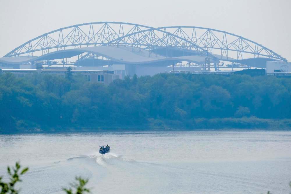
As water sources dry up and climate extremes cause drought and floods on the Prairies, a massive effort is underway to map the bottom of the Red River to measure its depth from South Dakota to Lake Winnipeg.
A complete bathymetric survey — similar to a topographical map but of river bottom elevations — hasn’t been done in more than 70 years, University of Manitoba engineering professor Shawn Clark said Friday. The information is used by hydraulic engineers to predict the relationship between river flows and water levels, he said.
“As an example, they’d be able to apply the runoff from a particular, significant rainfall event at Emerson to their model of the Red River, and then predict how the increase in water flow and level will move down to other locations along the river,” Clark said.
“The folks in the town of Morris, for example, would then know the timing of peak water levels near their town so that they’d know whether to take any flood-mitigation steps.”
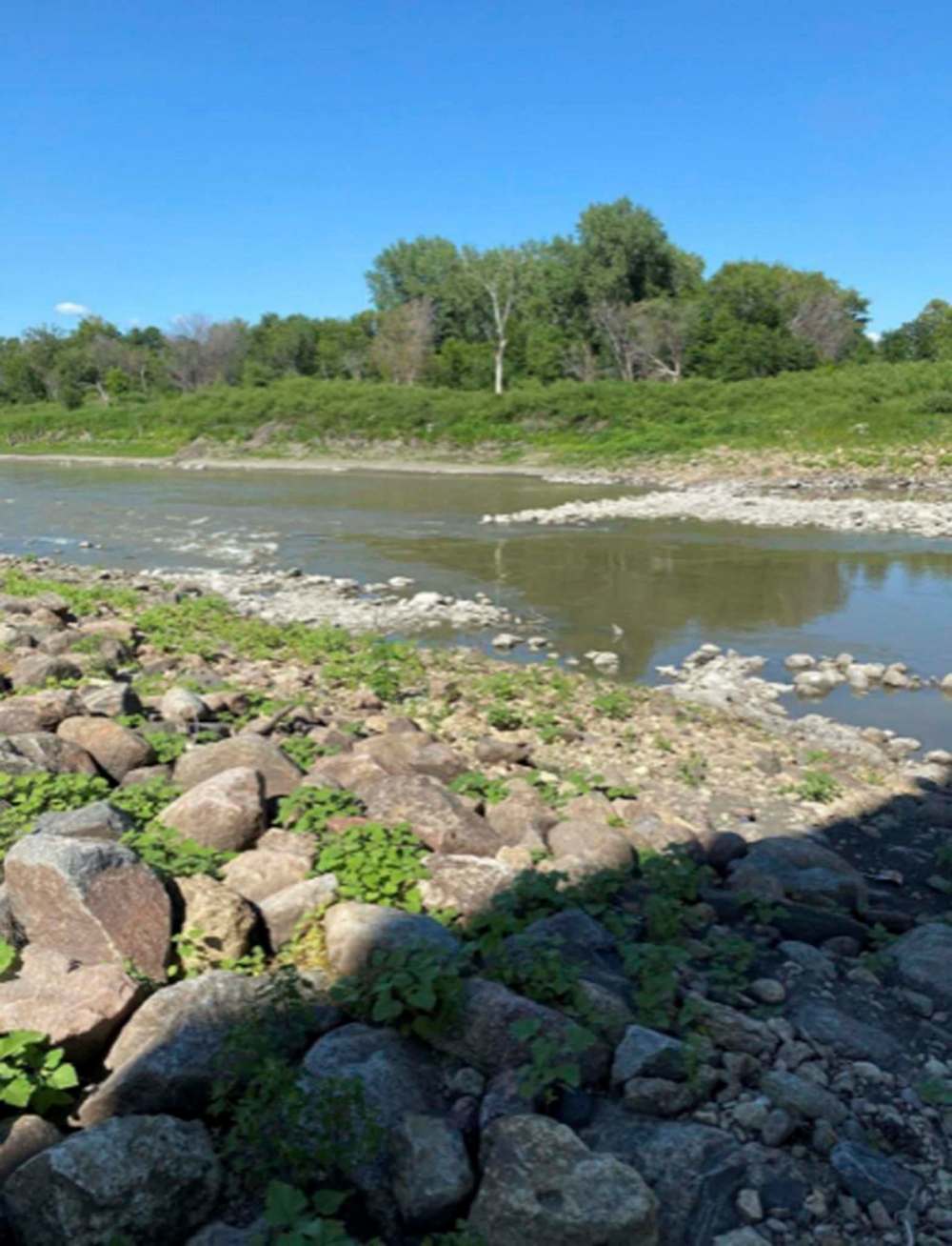
The Pembina Valley Water Co-operative, which Morris and Emerson belong to, declared an emergency last Wednesday and warned the Red River, which provides water to thousands in the region, could “dry up” by the end of September.
While the old bathymetric data taken on the Red River decades ago is still pretty good, Clark said at certain specific locations where there was a riverbank failure, for example, there may be fairly big differences between the old survey and the present day.
If the data is outdated or inaccurate, the hydraulic modelling that communities rely on will be inaccurate, he said. The results could be disastrous.
“If climate change will result in more frequent extremes — more significant floods and droughts — accurate bathymetric data for areas of interest, including the Red River, is very important,” Clark said.
The plan to survey the Red from South Dakota to Lake Winnipeg is a major undertaking, said Ted Preister, the head of the non-profit Red River Basin Commission. The cross-border organization’s members include local, state (both Dakotas and Minnesota), Manitoba and First Nations representatives.
“Most bathymetric data for the whole river is indeed from the 1950s,” said Preister in Fargo, N.D. “There are some spots where there have been big projects that have updated info, but nothing like this,” he said. The current digital systems use sonar-like information to measure every five centimetres across and up and down the length of the river.
The 1950s data involved one manual survey transect every few miles, Preister said, “meaning that a guy with a stick measured how deep the water was every .25 metres or so in a straight line across the river.”
The U.S. Corps of Engineers has already started the new survey south of the border. Preister expects funding approval will be granted in late August to see it completed to the Red River’s endpoint at Lake Winnipeg.
“There are many, many potential benefits, including getting a good gauge of how much water the channel can hold at any point, gaining perspectives on erosional forces — especially if we could do it again in five to 10 years — how much good fish habitat is there; and those are just the ones off the top of my head,” Preister said. The Red River resource can’t be taken for granted.
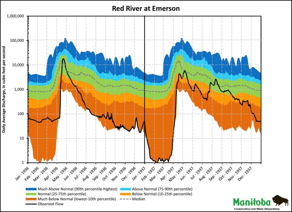
In Winnipeg, commission managing director Steve Strang said the Red River is known to have run dry once during the Dirty ‘30s — in February 1937, when the observable flow at Emerson was less than one cubic foot per second.
“Hopefully, this will not be the second one,” Strang said of the current long-term drought that’s cut the Red River flow at Emerson in half and resulted in river levels dropping at alarming rates in recent weeks.
“The drought will strongly affect many in the southern region and efforts are already in place to adapt to the changes of the low water, such as lowering their inlets,” Strang said.
Rivers don’t have borders and climate change should motivate countries to work together now more than ever to manage the resource, said Clark at the U of M.
Preister said he wants the cross-border Red River bathymetric survey to be the example.
“It will be one of only a handful of coherent, complete trans-boundary data sets, of any type, on the entire border — another example of how collaboration benefits us all.”
carol.sanders@freepress.mb.ca
Carol Sanders
Legislature reporter
Carol Sanders is a reporter at the Free Press legislature bureau. The former general assignment reporter and copy editor joined the paper in 1997. Read more about Carol.
Every piece of reporting Carol produces is reviewed by an editing team before it is posted online or published in print — part of the Free Press‘s tradition, since 1872, of producing reliable independent journalism. Read more about Free Press’s history and mandate, and learn how our newsroom operates.
Our newsroom depends on a growing audience of readers to power our journalism. If you are not a paid reader, please consider becoming a subscriber.
Our newsroom depends on its audience of readers to power our journalism. Thank you for your support.
Advertisement Advertise With Us
Advertisement Advertise With Us