

Spring flood risk ‘high’ along Red River near border, U.S. weather service warns
Advertisement
Read this article for free:
or
Already have an account? Log in here »
To continue reading, please subscribe:
Monthly Digital Subscription
$1 per week for 24 weeks*
- Enjoy unlimited reading on winnipegfreepress.com
- Read the E-Edition, our digital replica newspaper
- Access News Break, our award-winning app
- Play interactive puzzles
*Billed as $4.00 plus GST every four weeks. After 24 weeks, price increases to the regular rate of $19.00 plus GST every four weeks. Offer available to new and qualified returning subscribers only. Cancel any time.
Monthly Digital Subscription
$4.75/week*
- Enjoy unlimited reading on winnipegfreepress.com
- Read the E-Edition, our digital replica newspaper
- Access News Break, our award-winning app
- Play interactive puzzles
*Billed as $19 plus GST every four weeks. Cancel any time.
To continue reading, please subscribe:
Add Winnipeg Free Press access to your Brandon Sun subscription for only
$1 for the first 4 weeks*
*$1 will be added to your next bill. After your 4 weeks access is complete your rate will increase by $0.00 a X percent off the regular rate.
Read unlimited articles for free today:
or
Already have an account? Log in here »
Hey there, time traveller!
This article was published 22/02/2019 (2416 days ago), so information in it may no longer be current.
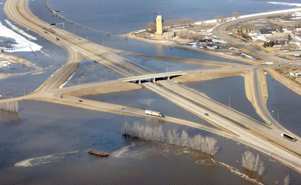
The U.S. National Weather Service says there is a high risk of major flooding on the Red River near the Manitoba border this spring.
In a new report, the weather service says recent heavy snowfall and deeper-than-normal frost depths could lead to greater spring runoff.
Greg Gust, warning co-ordination meteorologist in Grand Forks, said since Oct. 1 the amount of rain and snow that has fallen in the U.S. Red River basin is in the top 10 to 15 per cent of recorded years dating back well more than a century.
“We’re not expecting at this point record-setting flooding, just substantial,” he said in an interview.
The weather service defines a “high risk” of major flooding as greater than 65 per cent.
Manitoba will issue its first flood forecast of the year “soon,” a provincial spokesman said Friday. “No exact date (has been set) as data is plugged into computer models and crunched right up to the last moment,” he said in an email.
Several locations south of the border recorded record or near record snowfall for the month of February, including Grand Forks and Fargo.
“The current snowpack across the (Red River basin in the U.S.) is now considered above normal, especially east of the Red River into northwestern Minnesota,” the weather service said in its report.
One mitigating factor is that there was little standing water in ditches and sloughs prior to freeze up. Precipitation in the region has generally been below normal the past couple of years. Soil moisture at freeze-up near the international border was below-normal, the weather service said.
However, significant overland flooding is possible given current conditions.
“At these levels, you aren’t likely to be shutting down (Interstate) 29, but you’ll certainly be seeing (water) in the fields. Likewise on Highway 75 on the Minnesota side…You’d need quite a bit more (precipitation).”

Frost depths are slightly deeper than normal due to the recent colder-than-normal conditions and the lack (until recently) of a deep snow cover. Deeper frosts can lead to greater spring runoff, since the water is less likely to soak into the ground.
The U.S. report says that several factors will determine the seriousness of flooding this spring, including future snowfall, the rate and timing of the snow melt, whether there is heavy rain or snow on still-frozen ground this spring and river ice jams.
“The (current) active weather pattern is expected to continue for the near term before trending back towards a more normal pattern,” the weather service said.
“Current projections are for the cold conditions to continue with below-normal temperatures expected to persist into mid-March.”
larry.kusch@freepress.mb.ca
History
Updated on Friday, February 22, 2019 5:23 PM CST: Final version.