

Falling in Northern Manitoba
Advertisement
Read this article for free:
or
Already have an account? Log in here »
To continue reading, please subscribe:
Digital Subscription
One year of digital access for only $1.44 a week*
- Enjoy unlimited reading on winnipegfreepress.com
- Read the E-Edition, our digital replica newspaper
- Access News Break, our award-winning app
- Play interactive puzzles
*Billed as $5.77 plus GST every four weeks. After 52 weeks, price increases to the regular rate of $19.95 plus GST every four weeks. Offer available to new and qualified returning subscribers only. Cancel any time.
To continue reading, please subscribe:
Add Free Press access to your Brandon Sun subscription for only an additional
$1 for the first 4 weeks*
- Enjoy unlimited reading on winnipegfreepress.com
- Read the E-Edition, our digital replica newspaper
- Access News Break, our award-winning app
- Play interactive puzzles
*Your next Brandon Sun subscription payment will increase by $1.00 and you will be charged $17.95 plus GST for four weeks. After four weeks, your payment will increase to $24.95 plus GST every four weeks.
Read unlimited articles for free today:
or
Already have an account? Log in here »
Hey there, time traveller!
This article was published 05/08/2010 (5803 days ago), so information in it may no longer be current.
Pisew Falls Provincial Park
Wekusko Falls Provincial Park
Sasagiu Rapids Provincial Park
Little Limestone Lake
For hundreds of years the Grass River served as the major “highway” of the north. Cree hunters, followed by European explorers and fur traders, used the Grass River as their primary transportation route across northern Manitoba.
It has been many years since roads have replaced the river as the primary artery of the north. The Grass River is now a tourist destination and no longer a route of exploration and commerce.
In the late 1700s, the Grass River was known as the Upper Track of the western Canadian fur trade. It served as the route for transporting furs from the trap lines of Rupertsland to the Hudson Bay Company and Northwest Company fur depots on the Hudson Bay coast. The Grass River was the vital link between the aboriginal trappers along the Saskatchewan River and the ocean-going ships that would transport furs to Europe.
The Grass River was also used by European explorers searching for an overland route to the Pacific Ocean. Both David Thompson and Samuel Hearne travelled up the river as they ventured deep into the unknown western Canadian interior.
This week’s journey focused on three parks along the Grass River: Pisew Falls Provincial Park, Sasagiu Rapids Provincial Park, and Wekusko Falls Provincial Park. My friends and I also made a stop at Little Limestone Lake, a proposed provincial park site, and we also made a return visit to Paint Lake Provincial Park, our base of operations.
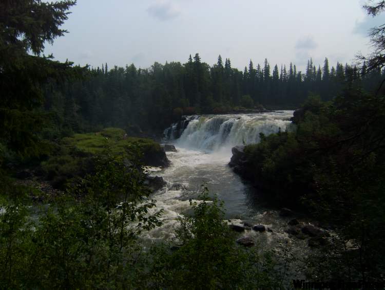
Pisew Falls Provincial Park is located just off Highway 6, roughly 75 kilometres south of Thompson. At 13 metres high, Pisew Falls is Manitoba’s second-highest waterfall, only one metre shorter than its neighbour, Kwasitchewan Falls.
The two sets of falls are connected by a 22-kilometre hiking trail. Unfortunately, we did not have time to undertake the hike. That said, Pisew Falls alone was worth the trip. The sight of the Grass River plunging over a rock face between two large moss-covered plateaus, nourished by the falls’ mist, was one that I’ll never forget.
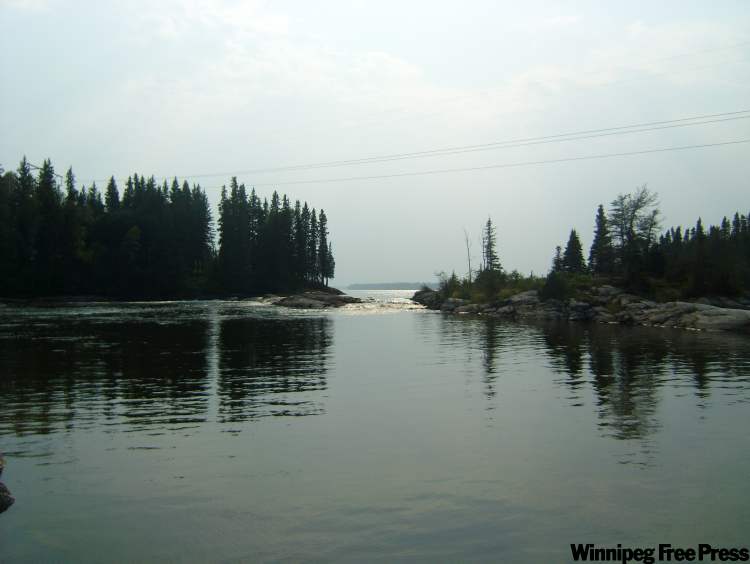
Sasagiu Rapids Provincial Park is roughly ten kilometres south of Pisew Falls, on Highway 6. The park has a very small campground along the side of the highway, with a boat launch providing the only access to the Grass River.
The Sasagiu Rapids rage directly beneath the highway bridge adjacent to the park. We stopped here briefly, scrambling down the highway embankment and relaxing on the rocks that constrain the river’s flow. Sasagiu Rapids Provincial Park is a great place to take a breather during a long drive, but that’s about it.
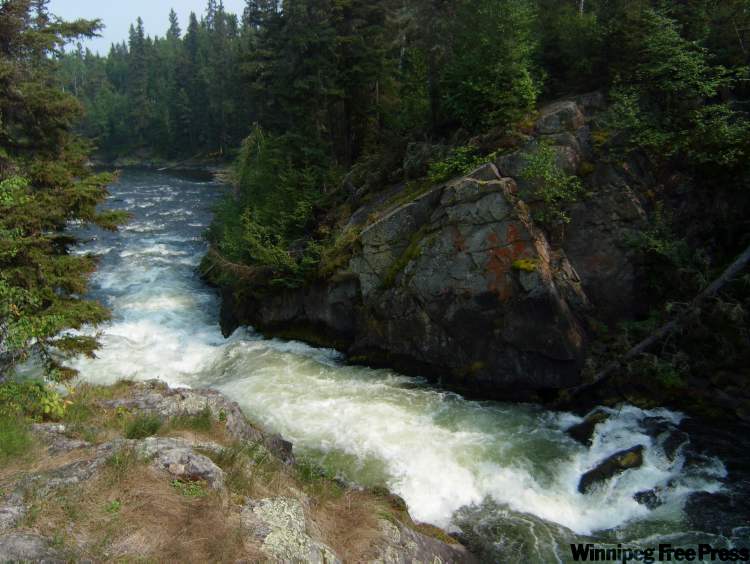
Wekusko Falls Provincial Park is approximately 15 kilometres south of the town of Snow Lake, on Provincial Road 392. Here, the Grass River drops 12 metres through a series of rapids and falls. The centrepiece of the park is Wekusko Falls, which can be viewed from a suspension bridge built in 1961 by the Canadian Army Engineers.
The view from the suspension bridge is spectacular. To the left, the falls cascade down and to the right the Grass River cuts a violent swath through a narrow gorge. The park is a great spot to stop and unwind for a few hours if you’re travelling through the area.
//
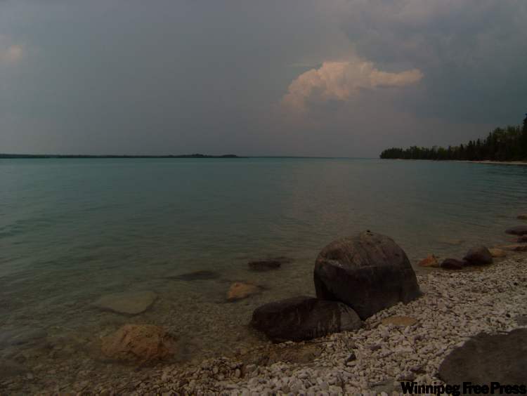
Our final stop on this week’s journey was at Little Limestone Lake, north of Grand Rapids on Highway 6. The provincial government recently announced a proposal to create a provincial park around this lake.

Little Limestone Lake is a rare marl lake – the colour of water changes depending on the temperature of the air around the lake. As the temperature rises, more water evaporates and the amount of calcite in the water increases, changing the lake’s colour. The cave-riddled limestone underneath the lake causes this process.
I’ve never seen a lake like Little Limestone. The water is a striking aquamarine colour similar to that of the Mediterranean Sea. The water is perfectly clear, no algae, no visible plants, almost like glacial water.
I can understand why the province is interested in preserving this lake in its pristine state. If you are interested in seeing the most striking lake in Manitoba, make a trip to Little Limestone.
Our second trip to northern Manitoba was interesting and awe inspiring, although a little bit rushed because of the distance we had to travel in three days. It’s worth the time and effort to travel to the lakes and rivers of the north, especially if you could take at least a week. Things haven’t changed much since the days of the fur trade.
Parks visited in today’s post:
View A(sessippi) to Z(ed Lake) in a larger map