

Manitoba mountain high
Provincial park offers hiking, water sports and lovely wilderness vistas
Advertisement
Read this article for free:
or
Already have an account? Log in here »
To continue reading, please subscribe:
Digital Subscription
One year of digital access for only $1.44 a week*
- Enjoy unlimited reading on winnipegfreepress.com
- Read the E-Edition, our digital replica newspaper
- Access News Break, our award-winning app
- Play interactive puzzles
*Billed as $5.77 plus GST every four weeks. After 52 weeks, price increases to the regular rate of $19.95 plus GST every four weeks. Offer available to new and qualified returning subscribers only. Cancel any time.
To continue reading, please subscribe:
Add Free Press access to your Brandon Sun subscription for only an additional
$1 for the first 4 weeks*
- Enjoy unlimited reading on winnipegfreepress.com
- Read the E-Edition, our digital replica newspaper
- Access News Break, our award-winning app
- Play interactive puzzles
*Your next Brandon Sun subscription payment will increase by $1.00 and you will be charged $17.95 plus GST for four weeks. After four weeks, your payment will increase to $24.95 plus GST every four weeks.
Read unlimited articles for free today:
or
Already have an account? Log in here »
Hey there, time traveller!
This article was published 14/07/2012 (5077 days ago), so information in it may no longer be current.
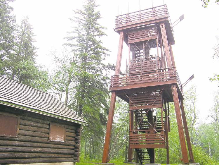
A cool, ceaseless rain pelts down from the stern sky, as Eleanor Burgess and I carefully climb the winding slick stairs to the top of the 12-metre-high wooden viewing tower on Baldy Mountain, Manitoba’s highest peak at 831 metres above sea level, located in Duck Mountain Provincial Park, about 440 kilometres northwest of Winnipeg.
Water drips from my clammy rain gear as we reach the upper viewing platform.
It seems as if the world is wet with tears.

If the day were clear instead of shrouded by mist, then we would look over a forest of tall spruce and aspen all the way to Riding Mountain National Park, some 65 or so kilometres south of here, says Burgess, who is Conservation Manitoba’s Mountain district park supervisor.
Despite the monsoon-like weather, I feel invigorated by the brisk breeze and sharp smell of this pure wilderness air.
After, I take an unexpected spill on the glistening grass while hiking with Burgess the short distance along the trail to an old cabin and stable that were built in the early forestry days of Duck Mountain.
I drove by the park many years before on a work-related trip to a nearby town, but this is my first visit inside the park (a place I’ve long wanted to experience), which lies wholly within Duck Mountain Provincial Forest.
With an area of 1,424 square kilometres, the park (the only provincial park that allows logging within its boundaries) is characterized by forested hills interspersed with lakes, notes information in the interpretive park map, which was supplied to me by Travel Manitoba, who provided me with support on this trip.
“River valleys, wetlands and streams are characteristic of the area’s glacial origins,” the material says.
“Classified as a natural park, its purpose is to preserve areas that are representative of the western upland natural region and to accommodate a diversity of recreational opportunities and resource uses.”
The shapes of landforms and bodies of water that make up Manitoba’s diverse landscape are largely the work of the last ice age and of glacial Lake Agassiz, which was formed from meltwater.
About 10,000 to 12,000 years ago, when the glaciers were receding northward, Duck Mountain emerged as one of the first areas of dry land.
“Early nomadic tribes came to this new land to hunt animals such as the now extinct mammoth,” says an interpretive plaque on one of the park’s hiking trails.
“Duck Mountain is one segment of a long series of highlands in western Manitoba, collectively known as the Manitoba Escarpment.”
The highlands and the broad valleys that separate them all have a similar shale core that was formed during the cretaceous period, between 60 million and 130 million years ago, at the bottom of a shallow saltwater sea.
“When the sea disappeared, the land was lifted, and a long period of sedimentation was followed by a long period of erosion,” according to the provincial map.
“Ancient rivers and advancing glaciers wore away the areas of softer shale. This grand-scale erosion created the valleys and left the highlands with a steep eastern face or escarpment.”
The park’s lakes and ponds are a legacy of glacial times and the changes that have occurred since.
Meltwater filled the depressions, forming many pothole lakes. Some of these have since filled in with vegetation to become black spruce bogs. Other lakes, fed by springs and spring runoff, have remained clear.
For example, East Blue Lake is one of the province’s clearest lakes. It is almost 60 metres deep.
“The RCMP use this lake to train their members in scuba diving,” says Arch Dowsett, who, along with his wife, Dawn, owns and operates the Blue Lake Lodge, on the shore of East Blue Lake. We converse in their small store/coffee shop.
2Other centres of development in the park are at Wellman, Singush and Childs lakes. During lunch at the Wellman Lake Lodge, Burgess notes the sailing events for the upcoming 2012 Manitoba Summer Games will be held on Wellman Lake.
“Native and stocked fish species are plentiful in most of the lakes and streams in the park,” says Wayne Dobbie, an operations consultant/guide at Blue Lakes Lodge and reeve of the R.M. of Whitehead, as we bump along pothole-studded Provincial Road 366 in his Ford 4×4 F-150 truck.
He points out the variety of trout (rainbow, brook, speckled, brown, lake and hybrids) are “a flyfisher’s delight” and with walleye, yellow perch, lake whitefish, northern pike and muskellunge, angling opportunities of all kinds are available in the park during the open-water season and the winter months.
The varying landscape of Duck Mountain supports other animals, such as moose, white-tailed deer, black bear, fox, lynx, coyote and timber wolf. A variety of birds nest in the marshes and forests. The haunting call of loons or even sometimes of red-necked grebes, the howls of coyotes and wolves or the bugle of elk in autumn will often add excitement to a night’s stay.
We eventually reach our destination on this pouring day: Shilliday Lake.
“This lake was named after Flight Sgt. Robert Charles Shilliday, RCAF. Killed in action the 16th of January, 1945, at age 19,” says a metal marker that lies in the bush near the lake.
Burgess and I also hike the winding trail to the top of Copernicus Hill, where there’s a monument to Polish-born Nicolaus Copernicus (1473-1543), the “founder of modern astronomy.”
The plaque, which was presented by the Canadian Polish Community/Nicolaus Copernicus Observance Committee of Manitoba on the occasion of the 500th anniversary of Copernicus’s birth, describes “his work that changed the course of human history.”
A viewing tower provides an impressive northward view. From here, hikers can also access the Glad Lake trail, with a return distance, from the Prieston Lake trailhead, of a little more than one kilometre.
Burgess points out such ground cover as bearberry, wintergreen, clubmoss, sarsaparilla and wild rose. The trees are a mixture of white spruce, jack pine, balsam fir and deciduous trees such as aspen and birch.
We even spot a beautiful mountain ash in full bloom.
A sudden break in the rain on my final evening in the park affords Wayne Dobbie and I the chance to take a canoe out on adjacent West Blue Lake.
The calm, clear waters are perfect for paddling.
We see several loons, a couple of great blue herons, and an osprey that dives bombs one of the herons (a possible warning not to stray too close to its part of the lake?). We visit a large abandoned cabin with shattered windows, which was built on a hill overlooking the lake by a former provincial cabinet minister.
“People should travel more in this province,” Dobbie says the next morning as we hike up a muddy path and through thick, damp undergrowth to a West Blue Lake overlook with a wooden bench that’s scarred with carved initials.
“They would see the natural beauty that we have here in this park. I’ve met many people who don’t know about Duck Mountain Provincial Park. Maybe they’re only aware of it because it’s on the map.”
After my brief but rewarding visit, I have to agree with him: More must be done to promote (and protect) this special place as an ecotourist destination for Manitobans and others.
IF YOU GO
How to get there:
It’s about a five- to six-hour non-stop drive from Winnipeg to Duck Mountain Provincial Park.
I travelled west along the TransCanada Highway #1 to the Yellowhead Route, north through Riding Mountain National Park via Provincial Highway #10 to Dauphin, and then took #367 into Duck Mountain PP.
On the return trip, I drove south through the park down #366 towards the Town of Grandview, and then east down #5 into Dauphin and along the scenic eastern edge of Riding Mountain.
Roads are rough in Duck Mountain Provincial Park, especially if they haven’t been smoothed down with extra gravel. So, drive with caution and watch out for potholes.
Places to stay in Duck Mountain PP:
Blue Lakes Resort, located off Provincial Road 366 by East Blue Lake in the “heart” of Duck Mountain, is run by Arch and Dawn Dowsett. All eight rental cabins have a stove, fridge, pots and pans, toaster, kettle, dish towels, dishes, cutlery and running water. For guests who stay in a cabin with no shower, there’s a coin-operated shower house.
There is a large sand beach with a wonderful play structure for the kids, a boat launch and a diver’s dock to use at your own convenience. Tel: (204) 480-9393; Email: waynedobbie@rocketmail.com; Website: www.bluelakesresort.com
Provincial Park Campground: Located at East/West Blue Lake,the campground has about 100 daily sites and 50 seasonal sites.
Other resorts in the park:
Child’s Lake Lodge: www.childslakelodge.com
Wellman Lake Lodge: www.wellmanlakelodge.com