

Water reaches record level in Minot
Slightly lower crest predicted for N.D. city
Advertisement
Read this article for free:
or
Already have an account? Log in here »
To continue reading, please subscribe:
Digital Subscription
One year of digital access for only $75*
- Enjoy unlimited reading on winnipegfreepress.com
- Read the E-Edition, our digital replica newspaper
- Access News Break, our award-winning app
- Play interactive puzzles
*Billed as $5.77 plus GST every four weeks. After 52 weeks, price increases to the regular rate of $19.95 plus GST every four weeks. Offer available to new and qualified returning subscribers only. Cancel any time.
Monthly Digital Subscription
$4.99/week*
- Enjoy unlimited reading on winnipegfreepress.com
- Read the E-Edition, our digital replica newspaper
- Access News Break, our award-winning app
- Play interactive puzzles
*Billed as $19.95 plus GST every four weeks. Cancel any time.
To continue reading, please subscribe:
Add Free Press access to your Brandon Sun subscription for only an additional
$1 for the first 4 weeks*
- Enjoy unlimited reading on winnipegfreepress.com
- Read the E-Edition, our digital replica newspaper
- Access News Break, our award-winning app
- Play interactive puzzles
*Your next Brandon Sun subscription payment will increase by $1.00 and you will be charged $17.95 plus GST for four weeks. After four weeks, your payment will increase to $24.95 plus GST every four weeks.
Read unlimited articles for free today:
or
Already have an account? Log in here »
Hey there, time traveller!
This article was published 25/06/2011 (5448 days ago), so information in it may no longer be current.
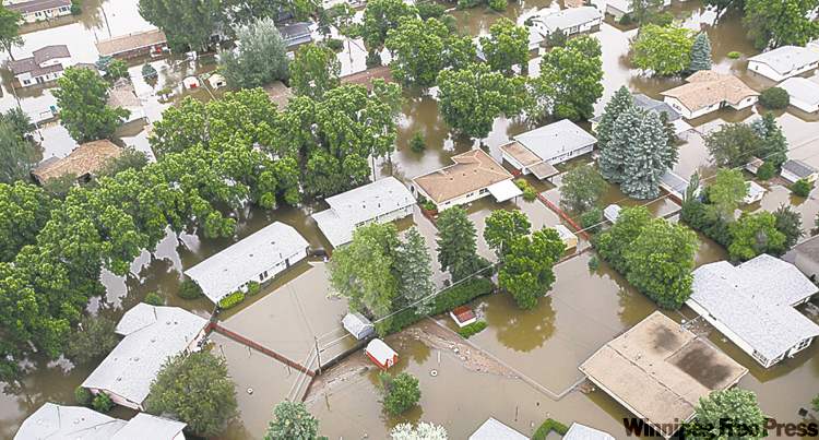
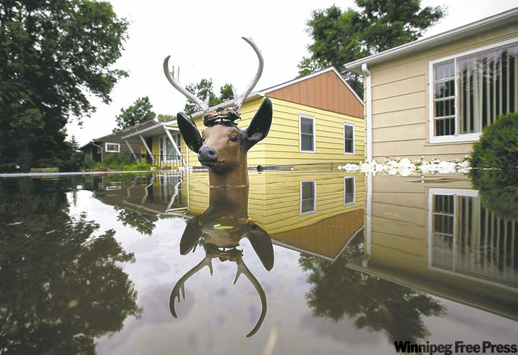
MINOT, N.D. — Though the Souris River flood is now officially the biggest the city of Minot, N.D., has ever seen, and a quarter of its population has been displaced, there were glimmers of hope Friday.
The projected crest is still much higher than the record flood of 1881, but the National Weather Service reduced it by nearly a foot from Friday morning.
Meanwhile, North Dakota’s congressional delegation said U.S. President Barack Obama’s administration and many members of Congress have pledged support for the stricken city of 41,000, the state’s fourth largest, and surrounding communities.
And the Federal Emergency Management Agency seemed amenable to offering aid to individual residents of Minot, according to one official.
The congressional delegation, along with Gov. Jack Dalrymple and Minot Mayor Curt Zimbelman, took an aerial tour of the flood Friday. Zimbelman said he saw only rooftops above water.
“It’s really tough to see,” said Republican Sen. John Hoeven, who is originally from Minot. “I see homes of people I’ve known since I was a little kid, places that I’ve been many many times in the city and outside the city — and now they’re underwater,” he said.
“We fought these floods — we fought them in ’69, we fought them in ’73, in ’76 — so now to see these homes in the water, it’s really tough.”
Before this flood, the highest the Souris River ever reached was in 1881, when it was at 1,558 feet above sea level at the point where the National Weather Service’s Broadway Bridge river gauge is now. The gauge showed the river was at level again at 11 a.m. Friday.
The weather service is projecting the river will crest at 1,563.6 feet at 1 a.m. Sunday, about a foot lower than its last projection. As of 4 p.m. Friday, the river level was at 1,559.8 feet, having risen more than two feet since noon.
“The end is in sight,” said Lt.-Col. Kendall Bergman, head of the U.S. Army Corps of Engineers’ St. Paul district, referring to receding waters at the Sherwood, N.D., river gauge upstream of Minot near the Canadian border. The crest passed the gauge early Friday morning.
Lake Darling, a flood-control reservoir operated by the corps, is between the border and Minot. Knowing how long the river will crest allows the corps to reduce the lake flow without fearing an even greater volume of water is on its way to max out the capacity of the lake, which is why a lower crest is now predicted.
But that could change if there is much rain.
“We are watching the weather very closely,” Zimbelman said. “Our greatest concern is thunderstorms over the Des Lacs River basin.”
The Des Lacs drains into the Souris upstream of Minot in the town of Burlington. The chance of a thunderstorm in that area Saturday is about 50 per cent, the weather service said.
Burlington threw in the towel Thursday and began evacuations after river levels rose too high and too fast for dike-building efforts.
Downstream of Minot, the flood fight continues.
“We’re feeling confident,” said Cy Kotaska, mayor of Sawyer, population 360. He expected contractors to finish raising the levees Friday evening or Saturday morning, he said, expressing renewed hope after hearing the lower crest prediction in Minot.
In Velva, population 1,100, city leaders asked the governor to mandate evacuation of most of the city, which sits in the Souris flood plain at the point where the river turns north to head back into Canada. Contractors continue to build up its levees, though, and they should be done Saturday or Sunday.
— Grand Forks Herald
Related Articles
Highway 22 closed Standing on guard

Advertisement Advertise With Us
Advertisement Advertise With Us