

One blizzard from catastrophe: report says Winnipeg ‘fortunate’ to escape 2011 without major flood
Advertisement
Read this article for free:
or
Already have an account? Log in here »
To continue reading, please subscribe:
Monthly Digital Subscription
$1 per week for 24 weeks*
- Enjoy unlimited reading on winnipegfreepress.com
- Read the E-Edition, our digital replica newspaper
- Access News Break, our award-winning app
- Play interactive puzzles
*Billed as $4.00 plus GST every four weeks. After 24 weeks, price increases to the regular rate of $19.95 plus GST every four weeks. Offer available to new and qualified returning subscribers only. Cancel any time.
Monthly Digital Subscription
$4.99/week*
- Enjoy unlimited reading on winnipegfreepress.com
- Read the E-Edition, our digital replica newspaper
- Access News Break, our award-winning app
- Play interactive puzzles
*Billed as $19.95 plus GST every four weeks. Cancel any time.
To continue reading, please subscribe:
Add Free Press access to your Brandon Sun subscription for only an additional
$1 for the first 4 weeks*
*Your next subscription payment will increase by $1.00 and you will be charged $16.99 plus GST for four weeks. After four weeks, your payment will increase to $23.99 plus GST every four weeks.
Read unlimited articles for free today:
or
Already have an account? Log in here »
Hey there, time traveller!
This article was published 10/09/2011 (5325 days ago), so information in it may no longer be current.
Winnipeggers well remember the deluge of 1997 as the Flood of the Century, but they should prepare for the likelihood that more floods of that magnitude are headed our way.
As the variability of southern Manitoba’s already volatile climate appears to be increasing, city flood-protection engineers are planning to deal with more severe floods, more often.
In a new report to city council, engineers disclose Winnipeg came within a blizzard of exceeding its flood-fighting capabilities in 2011, when worst-case-scenario forecasts led the city to prepare for the Red River to rise above 1997 levels.
The engineers are also asking council to immediately approve $1.9 million in spending to prepare for even more catastrophic floods, as the procedures and plans Winnipeg has in place right now are not sufficient to protect the city against a worsening wet cycle.
“The city was fortunate that there were no major precipitation events in April and snowmelt was gradual such that the city only experienced a more manageable flood event this year,” engineering manager Mike Shkolny writes in a report published Friday.
In a year that saw desperate flood fights on the Assiniboine, Souris, Fisher and other rivers — not to mention Lake Manitoba and Lake St. Martin — Manitoba Water Stewardship’s executive director concurred Winnipeg was fortunate.
“We got lucky on the Red. That was one of the saving graces,” Steve Topping said. “But we sat down with the city and started planning for the possibility of even greater floods.
“We know we go from wet cycles to drought cycles and we know climate change is happening, partly due to global warming and partly due to changes to the landscape.”
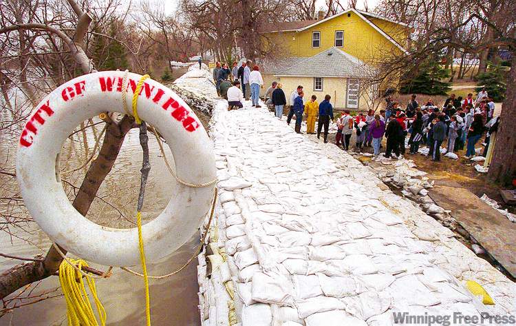
While the cause remains a matter of debate, southern Manitoba has endured a wet cycle since the mid-1990s. In 1997, the Red River flood crested at 24.5 feet above the historic normal winter ice level at the James Avenue monitoring station, or 24.5 feet James.
Although the flood fight that year was successful, the unexpected deluge forced city officials to scramble to figure out which drainage gates had to be shut, which manholes had to be sealed and which properties needed to be protected by sandbag dikes.
This effort was complicated by the creation of Unicity in 1972, which left the City of Winnipeg with an array of different mechanical devices and technology from 13 separate municipalities. Even worse, some of the staff familiar with the infrastructure had retired, depriving the city of institutional memory.
In the aftermath of the ’97 flood, the city and province vowed to avoid future confusion by creating Winnipeg’s flood manual, an interactive software program that allows engineers to figure out precisely what to do for any projected river level, right down to the schematics for individual drainage gates, the locations of manholes and the addresses of flood-affected properties.
This manual was updated after the 2005 summer flood, the 2006 spring flood and the 2009 ice-jam flood. But this year, after the province initially predicted the Red River could rise as high as 24.8 feet James, flood-protection engineers realized they would be forced to guess how to protect the city if the river wound up rising even higher.
“We have an upper limit on our flood manual,” said flood-protection planning engineer Grant Mohr, who pegs the existing limit at 25.2 feet James. “That still takes us up to 1997 conditions, but we have no idea what will happen in the near future.”
Mohr’s department is requesting $1.9 million to prepare for a Red River flood crest of 27.5 feet James and also improve the planning for catastrophic deluges on the Assiniboine River.
Mohr said he does not realistically expect to see a flood in excess of 26.5 feet in the near future, but said there’s no point upgrading the manual twice if the Canadian Prairies and U.S. Great Plains get even wetter.
“I’m thinking we’ll likely take it up to 27.5 feet because I don’t want to go back and do that again,” he said. “We want to make sure we get up there.”
Such measures are needed because the expansion of the Red River Floodway does not protect all Winnipeg properties from a severe flood. The floodway’s capacity was increased from 60,000 cubic feet per second to 140,000 CFS, at a cost of $660 million, to protect properties inside the city’s primary dikes.
But the floodway only provides partial protection to the low-lying properties sitting outside Winnipeg’s primary dikes, in low-lying neighbourhoods such as Kingston Crescent.
As well, the original floodway expansion plan included a call for the City of Winnipeg to upgrade its own flood-protection procedures. Winnipeg’s flood-protection engineers are merely planning to speed up those preparations by three years.

“With the continued wet weather cycle, the probability of extreme events like 1997 or greater dictate that the flood manual update be given a higher priority such that its upper range of functionality is expanded sooner,” Shkolny writes in his report to council.
“Through consultation with the province and review of the floodway operating rules, the city expects that it will experience river levels in excess of 1997 flood levels for floods of a one-in-150-year magnitude, even with the expanded floodway.”
Of course, officials have no way of predicting when the next severe flood will occur. All they do know is conditions have become more variable in a section of North America already known for high variability.
“We have no normal James levels anymore,” Mohr said. “There’s a lot of variability built into this.”
bartley.kives@freepress.mb.ca