

Today’s opening of floodway unusually early
Advertisement
Read this article for free:
or
Already have an account? Log in here »
To continue reading, please subscribe:
Monthly Digital Subscription
$0 for the first 4 weeks*
- Enjoy unlimited reading on winnipegfreepress.com
- Read the E-Edition, our digital replica newspaper
- Access News Break, our award-winning app
- Play interactive puzzles
*No charge for 4 weeks then price increases to the regular rate of $19.00 plus GST every four weeks. Offer available to new and qualified returning subscribers only. Cancel any time.
Monthly Digital Subscription
$4.75/week*
- Enjoy unlimited reading on winnipegfreepress.com
- Read the E-Edition, our digital replica newspaper
- Access News Break, our award-winning app
- Play interactive puzzles
*Billed as $19 plus GST every four weeks. Cancel any time.
To continue reading, please subscribe:
Add Free Press access to your Brandon Sun subscription for only an additional
$1 for the first 4 weeks*
*Your next subscription payment will increase by $1.00 and you will be charged $16.99 plus GST for four weeks. After four weeks, your payment will increase to $23.99 plus GST every four weeks.
Read unlimited articles for free today:
or
Already have an account? Log in here »
Hey there, time traveller!
This article was published 31/03/2017 (3141 days ago), so information in it may no longer be current.
The opening of the Winnipeg floodway on the Red River this morning is one of the earliest on record.
The floodway didn’t open until April 29 in 2013. In 2011, it opened on April 9. It doesn’t open unless flooding presents a threat to property owners.
The opening, scheduled for 10 a.m. today, is in response to a sudden surge on the Red River that could see it rise this weekend to between 18.6 feet and 20.8 feet at James Avenue — as much as 12 feet higher than at the same time last year.
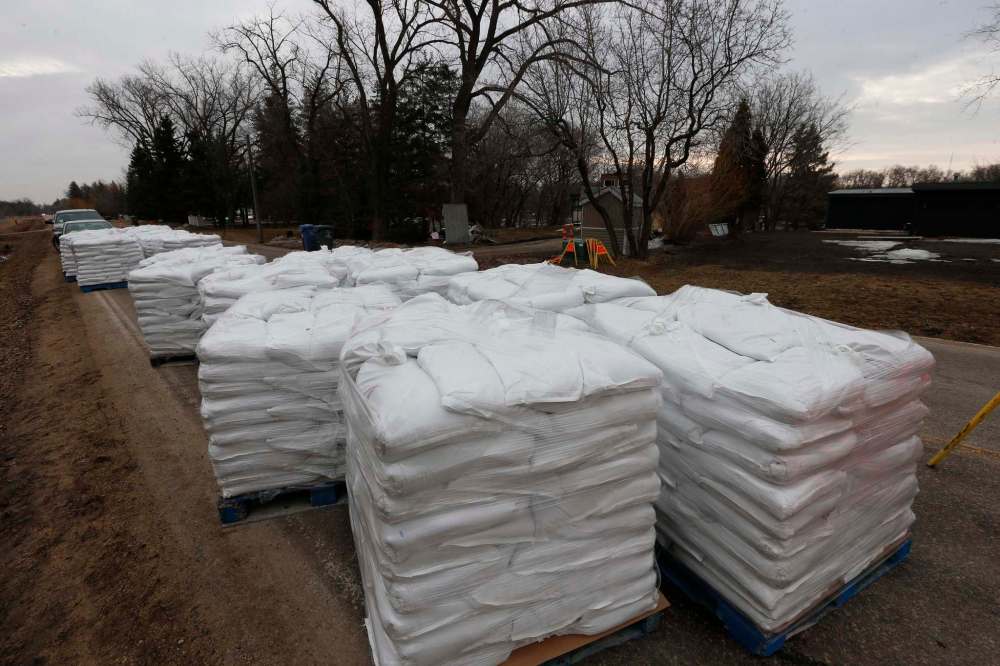
City officials said 75,000 sandbags were being prepared in time for the weekend. Sandbags were being delivered to 50 homes in low-lying areas across the city Thursday in anticipation of Red River levels not seen since the flood of 2011.
The decision to open the floodway was made after ice began moving freely through the control structure on Thursday.
“We have recently observed increasing flows along the Red River (Thursday) which caused us to identify a small number of properties along the Red River system that will require some temporary sandbag diking this weekend,” said Chris Carroll, the city’s manager of water services. “The levels that we’re experiencing are not to the extreme we’ve dealt with in the past… they’re fairly typical levels the city experiences on a fairly regular basis.”
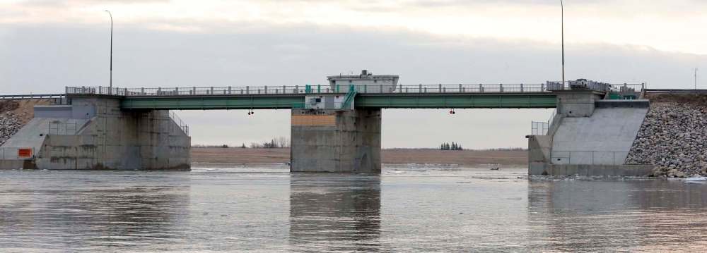
The floodway inlet is in St. Norbert. While it depends on the flow, it typically takes about 12 hours for the water in the floodway to reach its outlet north of Lockport in the RM of St. Andrews.
Local vernacular often describes the opening as “raising the gates.” In fact, it’s an underwater dam that is raised. The underwater dam blocks a good amount of river flow, causing water to rise high enough to flow over the lip of the floodway channel, which is slightly upstream.
Dubbed Duff’s Ditch, after Premier Duff Roblin who spearheaded its construction, it was built from 1962-68 at a cost of $63 million. It is estimated to have saved several billion dollars in property damage.
It required the excavation of 76.5 million cubic metres of earth over its 47-kilometre length. At the time, it was the second largest earth-moving project in the world after the Panama Canal.
After flirting with disaster in the 1997 flood, the floodway ditch was expanded to mitigate a flood of 1826 proportions, the year of the worst Red River flood on record.
Thursday afternoon, some residents along Cloutier Drive in St. Norbert were preparing for the rising Red River.
The backyard of one residence was mostly under water, and owners were planning to erect at least a two-foot wall of sandbags — which has turned into a ritual for the family.
“We do this every year,” said the man, who didn’t want to give his name. “It’s a spring tradition. A lot of it is precaution, to be honest. It’s more of a better-safe-than-sorry thing.”
But, he added: “It’s never been this close (to the home) this early.”
His neighbour, whose home has been at risk of flooding in the past, didn’t seem too concerned.
“I guess I have to go find out what I need to do,” he said, not wanting to be identified. “I never have (sandbagged), but you never know.”
Residents are loath to provide their names and addresses due to concerns about their property values falling.
A few doors down, Sumera Sahar said her home, which is on much higher ground, should be safe.
“We’re a bit more comfortable,” she said, standing on her back deck as chunks of ice floated past on the Red River. “But my husband is watching the flood reports all the time.”
Soil moisture saturation and heavy snowfall are blamed for the flooding threat this year.
Provincial officials said that despite conditions within the city, they don’t expect it will become necessary to close Highway 75. A provincial spokesman said the river level is high enough that water is spilling into the floodway channel naturally.
The city would not disclose the location of the homes where sandbags are being delivered, citing privacy concerns, but in previous years affected homes were usually located on Cloutier Drive, Christie Road, Kingston Row and Scotia Street.
The level of the Red at James Avenue was 15.8 feet Thursday morning, up 1.9 feet since Wednesday. Last April 1, it was 8.6 feet, and 7.8 feet on April 2.
The levels reflect the number of feet above normal winter ice levels at the point where downtown James Avenue meets the river downstream of The Forks.
Public works spokesman Ken Allen said the anticipated weekend river level is typical for this point in the season, adding the city is monitoring the situation closely.
“The city has experienced higher flood levels in the last decade for sure, so the levels we’re seeing are quite manageable from that perspective, and we’re well prepared for them,” Allen said. “We’re working around the clock, our teams are monitoring conditions, reacting very quickly to changing conditions. We’ll provide further updates as necessary.”
While Red River levels could reach those that were seen during 2011, a civic spokeswoman said the effect on homes has been mitigated by flood-protection measures taken by the city and private property owners, which has contributed to reducing the number of affected properties.
Carroll said the threatened properties are a priority and owners will receive hand-delivered notices to build sandbag dikes.
Despite the heightened concern, both Carroll and Allen said most of the affected homeowners have been through this before.
“The vast majority of the houses we’ve identified have been through these types of events in the past,” Carroll said. “For the most part, they are quite familiar with the activities we’re talking about here today.”
The city’s initiatives for this weekend are based on the province’s flood forecast from a week ago, which downgraded the threat of flooding across the province and projected the levels of the Red River to peak between 15 to 18 feet at James as long as there is no ice — the same forecast city officials provided Thursday. With ice, the city said the level could reach 20.8 feet.
Earlier predictions from the province suggested the Red could rise to 19.5 feet at James, given unfavourable weather conditions, and 22 feet if there was ice.
While heavy snowfall in December and January heightened concerns, Carroll said the weather conditions in February and March have been almost ideal and have mitigated the risk.
“The slow melt is helpful,” Carroll said. “The weather conditions are something we’re happy with.”

The spring thaw increases the risk of basement flooding in Winnipeg. When river levels are high, the normal capacity of the sewer system is reduced. With heavy rain, there is an increased risk of overloaded sewers backing up through residence sewer lines into basements that aren’t protected.
Although basement flooding can occur at any time of the year, the risk increases with high river levels because the sewer system must rely heavily on pumping stations rather than gravity to carry the rainfall runoff.
The public is encouraged to follow the City of Winnipeg on Facebook and Twitter (#WpgFlood) for updates and review information on winnipeg.ca/EmergWeb/.
With files from Randy Turner
aldo.santin@freepress.mb.ca
Related Articles
Homeowners deal with surge aftermath as river begins to subside


Advertisement Advertise With Us
Advertisement Advertise With Us
History
Updated on Friday, March 31, 2017 10:11 AM CDT: Photo added