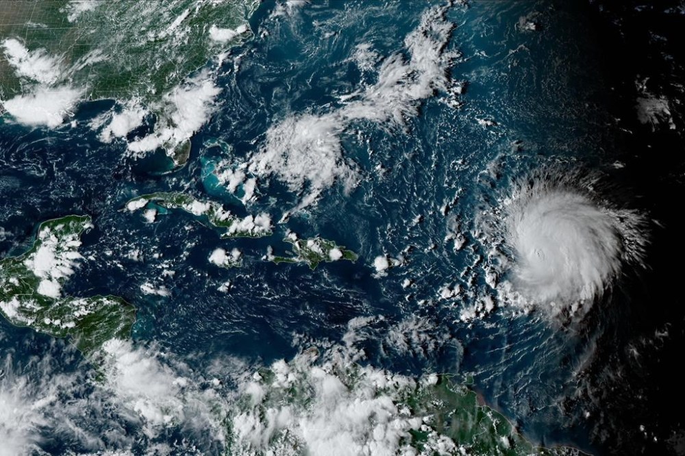
Hurricane Lee swirls through open waters on a path toward Atlantic Canada
Advertisement
Read this article for free:
or
Already have an account? Log in here »
To continue reading, please subscribe:

Digital Subscription
One year of digital access for only $205*
- Enjoy unlimited reading on winnipegfreepress.com
- Read the E-Edition, our digital replica newspaper
- Access News Break, our award-winning app
- Play interactive puzzles
*First annual payment billed as $205.00 + GST for one year. This annual subscription will automatically renew at $233.00 + GST every 52 weeks (10% off the regular annual price of $259.35). Offer available to new and qualified returning subscribers only. Cancel any time.
To continue reading, please subscribe:
Add Free Press access to your Brandon Sun subscription for only an additional
$1 for the first 4 weeks*
- Enjoy unlimited reading on winnipegfreepress.com
- Read the E-Edition, our digital replica newspaper
- Access News Break, our award-winning app
- Play interactive puzzles
*Your next Brandon Sun subscription payment will increase by $1.00 and you will be charged $17.95 plus GST for four weeks. After four weeks, your payment will increase to $24.95 plus GST every four weeks.
Read unlimited articles for free today:
or
Already have an account? Log in here »
Hey there, time traveller!
This article was published 12/09/2023 (1111 days ago), so information in it may no longer be current.
SAN JUAN, Puerto Rico (AP) — Hurricane Lee whirled north of Puerto Rico on Tuesday as a very large Category 3 storm, with forecasters noting it would remain in open waters through this week while on a path toward Atlantic Canada.
The storm was located about 535 miles (860 kilometers) south of Bermuda. It had winds of up to 115 mph (185 kph) and was moving west-northwest at 7 mph (11 kph).
A tropical storm watch was issued for Bermuda, with Lee forecast to pass just west of the island late Thursday, the National Hurricane Center said. It noted that Lee was “a very large hurricane,” with hurricane-force winds extending up to 125 miles (205 kilometers) from the center and tropical-storm-force winds up to 240 miles (390 kilometers).
By Sunday, Lee was forecast to weaken into a tropical storm and likely make landfall in Nova Scotia, Canada, according to AccuWeather.
“A significant storm surge will occur along with the strongest winds and risk of property damage,” AccuWeather said in a statement.
Winds and flooding also are expected to affect Rhode Island, eastern Massachusetts, southeastern New Hampshire and central and coastal Maine, forecasters said.
Lee is expected to weaken in upcoming days as it enters cooler waters.
“Despite the weakening that is forecast, keep in mind that the expanding wind field of Lee will produce impacts well away from the storm center,” the hurricane center said.

Lee was generating dangerous surf and rip currents for the Lesser Antilles, the British and U.S. Virgin Islands, Puerto Rico, Hispaniola, the Turks and Caicos Islands, the Bahamas, Bermuda and most of the U.S. East Coast.
“It remains too soon to know what level of additional impacts Lee might have along the northeastern U.S. coast and Atlantic Canada late this week and this weekend,” the National Hurricane Center said.
Lee is the 12th named storm of the Atlantic hurricane season, which runs from June 1 to Nov. 30 and peaked on Sunday.
Meanwhile, Margot became the fifth named hurricane of the season on Monday. It was located some 835 miles (1,345 kilometers) west-southwest of the Azores. It had maximum sustained winds of 80 mph (130 kph) and was moving north at 14 mph (22 kph). Margot is forecast to remain over open waters.
The National Oceanic and Atmospheric Administration has forecast 14 to 21 named storms this season. Six to 11 of those are expected to strengthen into hurricanes, and of those, two to five could develop into Category 3 storms or higher.
Related Articles
Lee's winds could be faster on arrival: forecast
Advertisement Advertise With Us
Advertisement Advertise With Us