

Heat dome shatters weather records across province

Advertisement
Read this article for free:
or
Already have an account? Log in here »
To continue reading, please subscribe:
Digital Subscription
One year of digital access for only $1.44 a week*
- Enjoy unlimited reading on winnipegfreepress.com
- Read the E-Edition, our digital replica newspaper
- Access News Break, our award-winning app
- Play interactive puzzles
*Billed as $5.77 plus GST every four weeks. After 52 weeks, price increases to the regular rate of $19.95 plus GST every four weeks. Offer available to new and qualified returning subscribers only. Cancel any time.
To continue reading, please subscribe:
Add Free Press access to your Brandon Sun subscription for only an additional
$1 for the first 4 weeks*
- Enjoy unlimited reading on winnipegfreepress.com
- Read the E-Edition, our digital replica newspaper
- Access News Break, our award-winning app
- Play interactive puzzles
*Your next Brandon Sun subscription payment will increase by $1.00 and you will be charged $17.95 plus GST for four weeks. After four weeks, your payment will increase to $24.95 plus GST every four weeks.
Read unlimited articles for free today:
or
Already have an account? Log in here »
This week’s heat wave is breaking records across Manitoba, including some that stood for more than 100 years, while some northern communities spend time as Canada’s hot spot.
Environment and Climate Change Canada, which issued a heat warning for most of Manitoba, said 24 communities set daily maximum temperature records for May 28 when temperatures soared Thursday, preliminary data show.
Brandon’s daytime high of 36 C eclipsed the record of 33.3 C set in 1901. Records have been kept in the western Manitoba city since 1890.

RUTH BONNEVILLE / FREE PRESS
Six-year-old Moses Hunter cools himself off in the splash pad at Provencher Park on Wednesday afternoon.
Five communities — Carman, Dauphin, Morden, Portage la Prairie and Winkler — broke records that were set in 1919. Thompson and Lynn Lake were among the northern communities to set new marks.
Dauphin was Canada’s hot spot early Thursday afternoon even before the city’s temperature peaked at 37 C.
The northern town of Snow Lake was Canada’s hot spot at about 12 p.m. Friday, when its temperature hit 33 C, but it was eclipsed by Grand Rapids’ temperature of 35 C a short time later as at least three more records fell.
Environment Canada said the following communities set new records for daytime highs Thursday:
- Altona: 34.9 C (the previous record of 34 C was set in 1986)
- Berens River: 30.8 C (30.1 C in 1986)
- Brandon: 36 C (33.3 C in 1901)
- Carberry: 36 C (33 C in 1986)
- Carman: 35.5 C (35 C in 1919)
- Dauphin: 37 C (35.6 C in 1919)
- Deerwood: 35.3 C (34 C in 1986)
- Dominion City: 34.1 C (34 C in 1986)
- Emerson: 34.1 C (34 C in 1986)
- Fisher Branch: 34.5 C (33 C in 1986)
- Gillam: 30.4 C (26.7 C in 1950)
- Grand Rapids: 37.3 C (32.5 C in 1986)
- Lynn Lake: 31 C (29.5 C in 1995)
- McCreary: 35.1 C (32 C in 1986)
- Melita: 35.3 C (32.2 C in 1936)
- Morden: 35.4 C (34.4 C in 1919)
- Oak Point: 32.2 C (32 C in 1986)
- Pilot Mound: 34.9 C (32.1 C in 1986)
- Portage la Prairie: 35 C (33.9 C in 1919)
- Shoal Lake: 34.6 C (31 C in 1986)
- Swan River: 36.6 C (33.5 C in 1986)
- The Pas: 35.7 C (33.3 C in 1944)
- Thompson: 32.2 C (32.1 C in 1986)
- Winkler: 35.4 C (34.4 C in 1919)
Environment Canada warning preparedness meteorologist Danielle Desjardins said three communities set records for May 29 as of early Friday afternoon, when temperatures were still climbing.
Grand Rapids’ temperature of 35 C eclipsed the record of 32 C, set in 1995. The Pas was just above its old mark of 31.5 C, also set in 1995.
Norway House’s temperature of 32.5 C beat the record of 31.3 C in 1988.
“There could be more by day’s end,” Desjardins said.
Daytime highs in the low to mid-30s and overnight lows in the high teens are expected into early next week, Environment Canada said.
An upper ridge of high pressure is stuck between low pressure to the east and west of Manitoba.
“That kind of drives the overall jet stream, so we are on the warm side… and not only that but it’s somewhat of a stagnant pattern,” Desjardins said.
The phenomenon is also known as a heat dome.
Environment Canada expects the core of the hottest temperatures to shift more toward the northern Interlake and the southern part of northern Manitoba on Saturday.

Desjardins said the ridge of high pressure will shift to the east, bringing weather that will be a little more unsettled early next week.
Rain and thunderstorms will be possible in some areas. Temperatures are expected to be slightly lower by Wednesday.
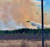
The heat wave has prompted concerns about people’s safety and an increased risk of wildfires. Environment Canada encouraged people to limited direct exposure to the sun, stay hydrated and take other steps to avoid heat-related illness.
Children and pets should not be left inside a parked vehicle, the weather agency warned.
chris.kitching@freepress.mb.ca
Chris Kitching is a general assignment reporter at the Free Press. He began his newspaper career in 2001, with stops in Winnipeg, Toronto and London, England, along the way. After returning to Winnipeg, he joined the Free Press in 2021, and now covers a little bit of everything for the newspaper. Read more about Chris.
Every piece of reporting Chris produces is reviewed by an editing team before it is posted online or published in print — part of the Free Press‘s tradition, since 1872, of producing reliable independent journalism. Read more about Free Press’s history and mandate, and learn how our newsroom operates.
Our newsroom depends on a growing audience of readers to power our journalism. If you are not a paid reader, please consider becoming a subscriber.
Our newsroom depends on its audience of readers to power our journalism. Thank you for your support.
Related Articles
Some Norway House residents forced to evacuate as wildfire nears


Advertisement Advertise With Us
Advertisement Advertise With Us