AP WAS THERE: 1991’s Hurricane Bob
Advertisement
Read this article for free:
or
Already have an account? Log in here »
To continue reading, please subscribe:

Digital Subscription
One year of digital access for only $205*
- Enjoy unlimited reading on winnipegfreepress.com
- Read the E-Edition, our digital replica newspaper
- Access News Break, our award-winning app
- Play interactive puzzles
*First annual payment billed as $205.00 + GST for one year. This annual subscription will automatically renew at $233.00 + GST every 52 weeks (10% off the regular annual price of $259.35). Offer available to new and qualified returning subscribers only. Cancel any time.
To continue reading, please subscribe:
Add Free Press access to your Brandon Sun subscription for only an additional
$1 for the first 4 weeks*
- Enjoy unlimited reading on winnipegfreepress.com
- Read the E-Edition, our digital replica newspaper
- Access News Break, our award-winning app
- Play interactive puzzles
*Your next Brandon Sun subscription payment will increase by $1.00 and you will be charged $17.95 plus GST for four weeks. After four weeks, your payment will increase to $24.95 plus GST every four weeks.
Read unlimited articles for free today:
or
Already have an account? Log in here »
Hey there, time traveller!
This article was published 20/08/2021 (1819 days ago), so information in it may no longer be current.
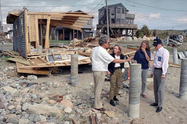
As New Englanders scramble to prepare for what could be their first hurricane in three decades, many can’t help but think of the last one — Bob, which made landfall as a devastating Category 2 storm.
Thursday marked exactly 30 years since Bob stormed ashore, killing at least 17 people and leaving behind more than $1.5 billion worth of damage. It left streets in coastal towns littered with boats blown free of their moorings and cut electricity and water to hundreds of thousands of homes and businesses for days.
The Associated Press covered the devastation. Thirty years later, the AP is making a version of its story from Aug. 19, 1991, available with photos.
___
Hurricane Bob Howls Into New England After Lashing Long Island, East Coast
Undated (AP) — Hurricane Bob howled into New England today after hammering Long Island and brushing the central East Coast with gusts up to 138 mph, and highways were snarled as vacationers and residents fled low-lying areas.
High wind cut electrical service to thousands and many state government offices shut down.
Earlier, the storm lashed North Carolina’s Outer Banks and other coastal sections with wind and heavy rain but did relatively little damage.
It was the first hurricane to strike into New England in six years.
At 3 p.m. EDT the center of the storm had crossed eastern Rhode Island and was centered at latitude 41.9 degrees north and longitude 71.1 west, or about 30 miles south of Boston. The storm had reached a sustained wind speed of 115 mph with gusts to 138 mph around its center.
Earlier, the hurricane’s calm eye passed over Block Island, off the coast of Rhode Island. The wind there reached at least 105 mph, said National Weather Service meteorologist Kevin Cadima. The island’s wind gauge ″blew out at 105, so it could have been higher,″ he said.
Some 2,000 to 2,500 people sought shelter in the Block Island school, a medical center and a sewage plant, said police and fire dispatcher Betty Gann.
As the eye passed over, she described the scene as ″absolutely dead; it’s almost frightening.″
Rhode Island and Massachusetts declared states of emergency, and a special storm barrier was lowered in Narragansett Bay to protect Providence, R.I. Most state workers in Maine and Massachusetts were told to go home early, and the Connecticut Legislature canceled a session.
Providence city officials said the hurricane’s storm surge rose to 8.5 feet at 3 p.m. at the storm barrier, which is designed to protect up to 20 feet.
Nuclear power plants in the region were taken off line as a precaution.
Today’s high tide of 8.9 feet at 7:43 p.m. in Portland, Maine, was expected to coincide with the arrival of the storm, which was expected to produce a storm surge of 5 feet to 8 feet.
The prospect of a surge, a wall of water that precedes a storm, also raised fears around Rhode Island’s Narragansett and Buzzards bays, the weather service said. A bay can magnify a surge as the water rushes into a narrower and narrower space.
Hurricanes in 1938 and 1954 pushed storm surges into downtown Providence at the head of Narragansett Bay, killed hundreds and did millions of dollars in damage. A hurricane barrier built since then was lowered today.
In eastern Long Island, some 300,000 residents were without power as a result of downed lines, said the Long Island Lighting Co. The eye of the storm had passed just east of the island. In Connecticut, Northeast Utilities reported that more than 100,000 customers had lost power by late morning, and about the same number lost service in Rhode Island.
Submarines left the Naval Submarine Base in Groton, Conn., and headed out to sea to submerge and ride out the storm safely away from piers. Airlines reported delays and the Trump Shuttle, serving Washington, New York and Boston, shut down until 2 p.m.
As the storm approached eastern Long Island, bumper-to-bumper traffic snaked westward in sheeting rain through Easthampton and water pooled up to a foot and a half deep in low spots. A downed power line blocked the main link to Montauk.
Though many residents were reluctant to leave their homes, ″they realize the situation is deteriorating rapidly and there they are cooperative,″ said Sgt. Howard Lewis of the Southampton Village police.
Ferry service across Long Island Sound between Long Island and Connecticut was shut down. Off the Rhode Island coast, Block Island residents and vacationers were stranded as the ferries stopped operating.
Thousands of Rhode Island shoreline residents evacuated homes and businesses. Gov. Bruce G. Sundlun said he ordered the state police to remove residents of low-lying areas forcibly, if necessary; a similar order was issued in parts of Long Island.
Sundlun closed the state’s roads to all but emergency traffic and canceled public bus service. He said the state would set up barricades at the Massachusetts and Connecticut borders, including along busy Interstate 95.
″It’s more prudent to have traffic jams than it is to have 18-wheelers cluttered along the road,″ Sundlun said.
People fled Massachusetts’ Cape Cod, which juts out into the ocean, and a line of traffic at least 11 miles long formed at the Sagamore Bridge linking the cape to the mainland.
On Chappaquiddick Island, people were ordered to evacuate to neighboring Martha’s Vineyard, where residents were taking shelter in churches and schools.
″People are getting nervous,″ said Rebecca Burns, a switchboard operator for the Nantucket Boat Basin marina on Nantucket Island. ″There have been a lot of calls. People are really concerned.″
In New York Harbor, ferry service to the Statue of Liberty and the Ellis Island Museum was canceled.
Rhode Island officials feared storm surges of water into the state’s heavily populated bays and declared a state of emergency. Banks and other non- essential businesses were ordered closed, as well as well as non-essential state offices.
″We’re preparing for what could be a direct hit to the state,″ Lt. Gov. Roger Begin said. He issued the executive order before Sundlun returned from a conference.
A state of emergency also was declared in Massachusetts, where Lt. Gov. Paul Cellucci ordered all non-public safety and non-essential state employees to go home at 11 a.m. The Coast Guard moved its aircraft from its base on Cape Cod to other bases inland.
Sunday night, the first hurricane of the Atlantic season knocked out power, toppled trees and caused flooding along North Carolina’s Outer Banks. There were at least two tornadoes.
Little major damage was reported, but a tornado overturned a mobile home on Hatteras Island in the Outer Banks, and a fish packing house at Hatteras was heavily damaged when wind ripped away the building front and part of the roof.
One drowning at Myrtle Beach, S.C., was blamed on high surf and strong undertow caused by the storm.
The storm brought steady rain and wind gusts only up to 50 mph at Maryland and Virginia resort communities, where the eye was 100 miles or so offshore.
Officials estimated about 1,000 people spent the night in shelters in Ocean City, Md., and surrounding Worcester County. But people in some oceanfront condominiums and hotels watched the storm’s progress from their balconies. A few even walked to water’s edge. Said one of them, Don Offhaus of Syracuse, N.Y.: ″I wanted to experience it. It certainly is an amazing display of nature.″
In southern New Jersey, the rain flooded local roads and wind downed some tree limbs, causing scattered power outages, emergency officials said.

Canada issued a high wind and heavy rain warning for Nova Scotia, New Brunswick and Prince Edward Island.
The last hurricane to hit Long Island and New England was Gloria in September 1985.
With sustained winds up to 115 mph, Bob was a Category 3 storm on an increasing scale of 1 to 5. A Category 3 storm can cause extensive damage.
Hurricane Hugo, which devastated the Carolinas and the Caribbean in 1989, had winds up to 135 mph, a Category 4 storm, when it hit Charleston, S.C.
Bob formed off the Bahamas on Friday and is the second named tropical storm of the 1991 season. The first storm, Ana, formed in early July and died in the North Atlantic without touching land.