Climate change could bring more monster storms like Hurricane Lee to New England
Advertisement
Read this article for free:
or
Already have an account? Log in here »
To continue reading, please subscribe:
Digital Subscription
One year of digital access for only $1.44 a week*
- Enjoy unlimited reading on winnipegfreepress.com
- Read the E-Edition, our digital replica newspaper
- Access News Break, our award-winning app
- Play interactive puzzles
*Billed as $5.77 plus GST every four weeks. After 52 weeks, price increases to the regular rate of $19.95 plus GST every four weeks. Offer available to new and qualified returning subscribers only. Cancel any time.
To continue reading, please subscribe:
Add Free Press access to your Brandon Sun subscription for only an additional
$1 for the first 4 weeks*
- Enjoy unlimited reading on winnipegfreepress.com
- Read the E-Edition, our digital replica newspaper
- Access News Break, our award-winning app
- Play interactive puzzles
*Your next Brandon Sun subscription payment will increase by $1.00 and you will be charged $17.95 plus GST for four weeks. After four weeks, your payment will increase to $24.95 plus GST every four weeks.
Read unlimited articles for free today:
or
Already have an account? Log in here »
Hey there, time traveller!
This article was published 16/09/2023 (1130 days ago), so information in it may no longer be current.
BOSTON (AP) — When it comes to hurricanes, New England can’t compete with Florida or the Caribbean.
But scientists said Friday the arrival of storms like Hurricane Lee this weekend could become more common in the region as the planet warms, including in places such as the Gulf of Maine.
Lee remained a Category 1 hurricane late Friday night with sustained winds of 80 mph (128 kph). The storm was forecast to brush the New England coast before making landfall later Saturday in the Canadian province of Nova Scotia. States of emergency were declared for Massachusetts and Maine.
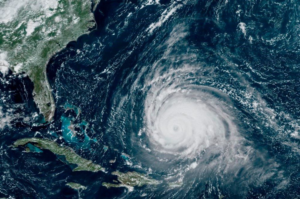
One recent study found climate change could result in hurricanes expanding their reach more often into mid-latitude regions, which include New York, Boston and even Beijing.
The study says the factors include warmer sea surface temperatures in these regions and the shifting and weakening of the jet streams, which are the strong bands of air currents encircling the planet in both hemispheres.
“These jet stream changes combined with the warmer ocean temperatures are making the mid-latitude more favorable to hurricanes,” said Joshua Studholme, a Yale University physicist and the study’s lead author. “Ultimately meaning that these regions are likely to see more storm formation, intensification and persistence.”
Another recent study simulated tropical cyclone tracks from pre-industrial times, modern times and a future with higher emissions. It found hurricanes will move north and east in the Atlantic. The research also found hurricanes would track closer to the coasts including Boston, New York and Norfolk, Virginia, and more likely form along the Southeast coast, giving New Englanders less time to prepare.
“We also found that hurricanes are more likely to move most slowly when they’re traveling along the U.S. East Coast, which causes their impacts to last longer and increase that duration of dealing with winds and storm surge,” said Andra Garner, lead study author and an assistant professor of environmental science at Rowan University in New Jersey.
Garner noted the study results included New York City and Boston.
Kerry Emanuel, a professor emeritus of atmospheric science at the Massachusetts Institute of Technology, who has long studied the physics of hurricanes, said parts of Maine will see more frequent hurricanes and heavier rains with each storm.
“We expect to see more hurricanes than we’ve seen in the last few decades. They should produce more rain and more wind,” said Emanuel, who lives in Maine. “We certainly have seen up here an increase in the destructiveness of winter storms, which is a very different beast. I would say the bulk of the evidence, the weight of the evidence, is that we’ll see more rain and more wind from these storms.”
One reason for the trend is the region’s warming waters.
The Gulf of Maine, for example, is warming faster than the vast majority of the world’s oceans. In 2022, the gulf recorded the second-warmest year on record, beating the old record by less than half a degree Fahrenheit. The average sea surface temperature was 53.66 degrees Fahrenheit (12 degrees Celsius), more than 3.7 degrees above the 40-year average, scientists said.
“Certainly, when we think about storms forming and traveling at more northern latitudes, sea surface temperature comes into play a lot because hurricanes need those really warm ocean waters to fuel them,” Garner said. “And if those warm ocean waters exist at higher latitudes than they used to, it makes it more possible for storms to move in those areas.”
While hurricanes and tropical storms are uncommon in New England, the region has been seen its share of violent weather events. The Great New England Hurricane of 1938 brought gusts as high as 186 mph (300 kph) and sustained winds of 121 mph (195 kph) at Massachusetts’ Blue Hill Observatory. Hurricanes Carol and Edna hit the region 11 days apart in 1954 and Hurricane Bob decimated Block Island in 1991.
Superstorm Sandy in 2012 caused damage across more than a dozen states and wreaked havoc in the Northeast when it made landfall near Atlantic City, New Jersey. Tropical Storm Irene killed six people in Vermont in August 2011, washing homes off their foundations and damaging or destroying more than 200 bridges and 500 miles (805 kilometers) of highway.
Experts warn that policy makers need to take projections of increased hurricane activity seriously and start upgrading their dams, roadways and neighborhoods for these future storms.
“We definitely in our coastal communities need to be thinking about how can we make our shorelines more resilient,” Garner said.

”Do we need to change,” she said, “where those flood zones are located, kind of thinking about how to perhaps protect the shorelines and think about solutions for that and adaptation kinds of things?”
Those making policy also can implement measures to keep emissions down so the worst effects of climate change don’t materialize, Garner said.
___
Follow Michael Casey on X, formerly Twitter: @mcasey1
___ Associated Press climate and environmental coverage receives support from several private foundations. See more about AP’s climate initiative here. The AP is solely responsible for all content.
Related Articles
Lee brings floods, outages to Maritimes
Advertisement Advertise With Us
Advertisement Advertise With Us