

Province upgrades flood threat, but says no repeat of 2011 levels
Advertisement
Read this article for free:
or
Already have an account? Log in here »
To continue reading, please subscribe:

Digital Subscription
One year of digital access for only $205*
- Enjoy unlimited reading on winnipegfreepress.com
- Read the E-Edition, our digital replica newspaper
- Access News Break, our award-winning app
- Play interactive puzzles
*First annual payment billed as $205.00 + GST for one year. This annual subscription will automatically renew at $233.00 + GST every 52 weeks (10% off the regular annual price of $259.35). Offer available to new and qualified returning subscribers only. Cancel any time.
To continue reading, please subscribe:
Add Free Press access to your Brandon Sun subscription for only an additional
$1 for the first 4 weeks*
- Enjoy unlimited reading on winnipegfreepress.com
- Read the E-Edition, our digital replica newspaper
- Access News Break, our award-winning app
- Play interactive puzzles
*Your next Brandon Sun subscription payment will increase by $1.00 and you will be charged $17.95 plus GST for four weeks. After four weeks, your payment will increase to $24.95 plus GST every four weeks.
Read unlimited articles for free today:
or
Already have an account? Log in here »
Hey there, time traveller!
This article was published 26/03/2013 (4951 days ago), so information in it may no longer be current.
The province upgraded the spring flood threat today in southern Manitoba to moderate to major depending on how the spring melt goes over the next month.
The trend is now for the southern part of the part of the province to experience a flood of the calibre of 2009, at that time the second-greatest flood on the Red River since 1997 and the floods of the 1880s.
Temperatures are expected to start climbing above zero next week at which point flood-fighting efforts across the south and at a couple of points in the north will start kicking in to an even higher gear.
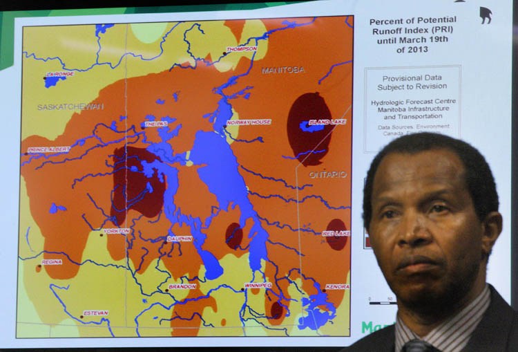
Officials caution that, despite a record snow pack across the prairies, flood-weary Manitobans won’t see a repeat of the record 2011 flood on the Assiniboine River.
That’s because the ground moisture conditions are a lot drier this spring than the big flood of 2011 when flooding in western Manitoba caused widespread damage. That year the ground was already saturated by heavy fall rains in 2010.
“Going into 2011 we had significant moisture going into the freeze-up,” Infrastructure and Highways Ministers Steve Ashton Monday during the province’s second flood briefing of the year. “We had record precipitation in the fall. That’s the big difference.
“Right now we have one area that’s significantly more favourable than 2011, the moisture content going into freeze-up.”
Officials also said flooding on the Assiniboine River, even with all the snow runoff from Saskatchewan, will be handled by the Shellmouth Reservoir near Russell and the Portage Diversion, which will safely funnel excess water into Lake Manitoba.
Lake Manitoba is forecasted to be at the top of its 812.5 feet above sea level operating range this spring, but four feet below what was experienced in 2011 when severe flooding destroyed hundreds of cottages, homes and farm properties.
However, officials also say there is so much water coming at us from Saskatchewan that it will overtop the Shellmouth Reservoir.
“There’s so much snow in Saskatchewan that we think under all three weather scenarios the Shellmouth will completely fill and will experience spillway flows,” said Steve Topping, executive director of hydrologic forecasting and water management. “There’s that much water stored in the snowpack upstream.”
Provincial forecasters also said there is an increased spring flooding potential on the Souris, Pembina, Saskatchewan and Qu’Appelle rivers, and in the Interlake, due to additional March snowfall.
But that does not mean we’ll see a flurry of dike-building and sandbagging in places like Wawanesa and Brandon as in 2011.
“In general terms the Souris River is about half of what it was for flood potential in 2011,” Topping said.
“We’re not right now looking at anything approaching a 2011 flood in Brandon or in the Assiniboine generally,” Ashton added.
They also said while the snowpack and ground moisture conditions in some portions of the province have increased the risk of flooding to moderate to major, up from minor to moderate as forecast last month, the new outlook does not foresee prolonged river flooding and high lake levels as in 2011.
They also said the colder-than-normal temperatures will also cause a later spring melt, which increases the likelihood of a rapid melt and threat of river ice jams. Cool temperatures later into the spring also increase the likelihood that the melting snowpack and normal spring rains will occur at the same time.
In 2009 flooding caused by ice jams on the Red River north of Winnipeg wiped out dozens of homes and cottages in Breezy Point north of Selkirk. It resulted in the buyout of 47 properties.
Ice jams that year also caused the Red River to peak in Winnipeg at 22.6 feet above normal winter-ice level, which amounted to the second-highest level in the city since the completion of the Red River Floodway.
The area to see the worst flooding this year is Red Deer Lake north of Swan River due to runoff from melting snow in Saskatchewan.
Also on the flood watch list is Peguis First Nation, about 145 kilometres north of Winnipeg. With poorer weather, the Fisher River could experience major flooding with levels slightly higher than 2009 levels.

Ashton said he’s already spoken to Peguis Chief Glenn Hudson and Assembly of Manitoba Chiefs Grand Chief Derek Nepinak on the threat. The province is ready to sandbag at-risk homes and will have heavy equipment in position to unclog ice jams at the community’s bridges to reduce flooding caused by ice jams.
In 2009 a state of emergency was declared in Peguis with 850 people evacuated to accommodations in Fisher Branch, Gimli, Portage La Prairie and Winnipeg. At the peak of the flood, 296 homes were affected, 169 of them seriously damaged.
Morris and Highway 75 south of Winnipeg is also expected to be closed due to flooding along the Red River. In 2009 the main route between Winnipeg and the United States was closed 37 days.
The Manitoba Trucking Association says each week the highway is closed costs truckers $1.4-$1.5 million in extra operating expenses.
The detailed outlook with text and charts will be available here.
Related Articles
Flooding expected close to 2009 levels, major in some areas
Advertisement Advertise With Us
Advertisement Advertise With Us
History
Updated on Tuesday, March 26, 2013 2:42 PM CDT: updates
Updated on Tuesday, March 26, 2013 2:50 PM CDT: corrects link
Updated on Tuesday, March 26, 2013 10:44 PM CDT: minor edit