

Archives all over the map with new exhibit

Advertisement
Read this article for free:
or
Already have an account? Log in here »
To continue reading, please subscribe:

Digital Subscription
One year of digital access for only $205*
- Enjoy unlimited reading on winnipegfreepress.com
- Read the E-Edition, our digital replica newspaper
- Access News Break, our award-winning app
- Play interactive puzzles
*First annual payment billed as $205.00 + GST for one year. This annual subscription will automatically renew at $233.00 + GST every 52 weeks (10% off the regular annual price of $259.35). Offer available to new and qualified returning subscribers only. Cancel any time.
To continue reading, please subscribe:
Add Free Press access to your Brandon Sun subscription for only an additional
$1 for the first 4 weeks*
- Enjoy unlimited reading on winnipegfreepress.com
- Read the E-Edition, our digital replica newspaper
- Access News Break, our award-winning app
- Play interactive puzzles
*Your next Brandon Sun subscription payment will increase by $1.00 and you will be charged $17.95 plus GST for four weeks. After four weeks, your payment will increase to $24.95 plus GST every four weeks.
Read unlimited articles for free today:
or
Already have an account? Log in here »
Hey there, time traveller!
This article was published 08/04/2024 (832 days ago), so information in it may no longer be current.
A new exhibit from Archives of Manitoba is perfectly mapped out.
About three dozen historic maps, some dating as far back as 1709, will be on display at 200 Vaughan St., Friday and Saturday from 1 p.m. to 5 p.m.
Kathleen Epp, keeper of the Hudson’s Bay Company Archives, said it’s a rare opportunity for the public.
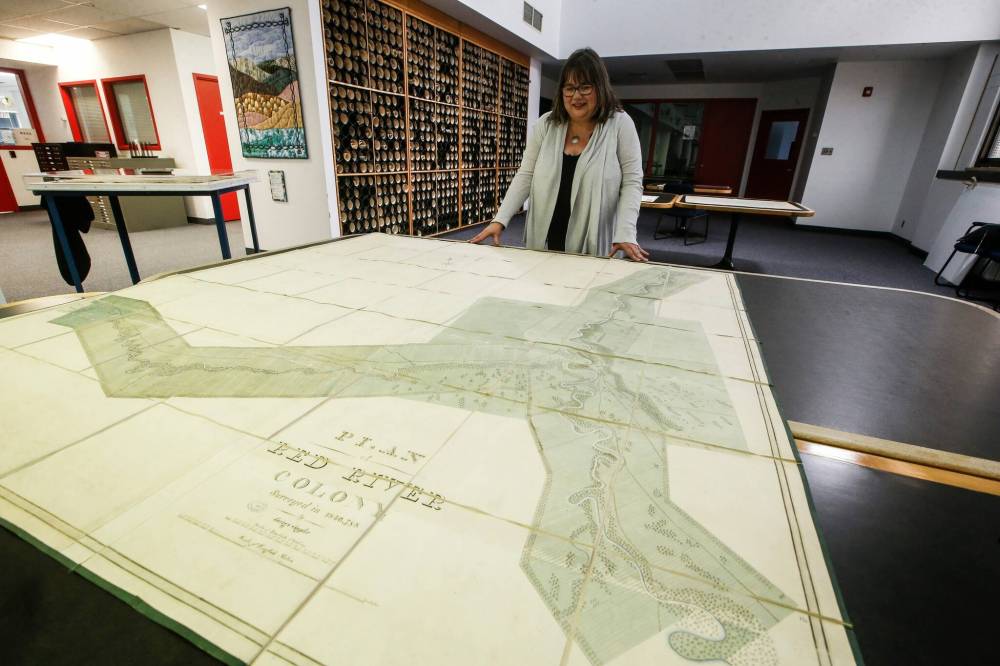
JOHN WOODS / FREE PRESS
Kathleen Epp, keeper of the Hudson’s Bay Company Archives, displays a Red River Colony map from 1836-38 in the Hudson’s Bay Archives collection at the Manitoba Archives in Winnipeg Monday. Archives Manitoba is having an open house Friday and Saturday and will be displaying three dozen maps dating back to 1709.
“I’ve been wanting to do this for a long time,” Epp said Monday. “Maps are fascinating documents, but a lot of them are just so big. Even here we don’t have the space normally to look at them side by side so this is also a treat for us.”
Epp said some of the earliest maps show what is now Western Canada, but they suddenly end before they get to the mountains in Alberta — and that proved problematic for at least two early explorers.
Ac Ko Mok Ki, a Blackfoot chief, made a drawing in the snow, showing directions on both sides of the Rocky Mountains. HBC cartographer Peter Fidler made a copy of it.
Epp said that copy was sent to England where a mapmaker used it to fill in the blanks on their maps in 1802.
“But (the mapmaker) didn’t understand it,” she said. “It was the Indigenous way of mapping.
“So when he saw a line, he thought it was the continental divide, but it wasn’t — it was the foothills. And that’s why, when Lewis and Clark used the map, they got lost.”
Epp said it is also interesting to see how the maps change as the years go by and how land was carved up for settlers.
“The history of mapping is also the history of colonialism,” she said. “It is all about land. They came, they carved it up and then came settlements.”
The archives will also display the Peguis-Selkirk Treaty of 1817, as well as the map that went with it.
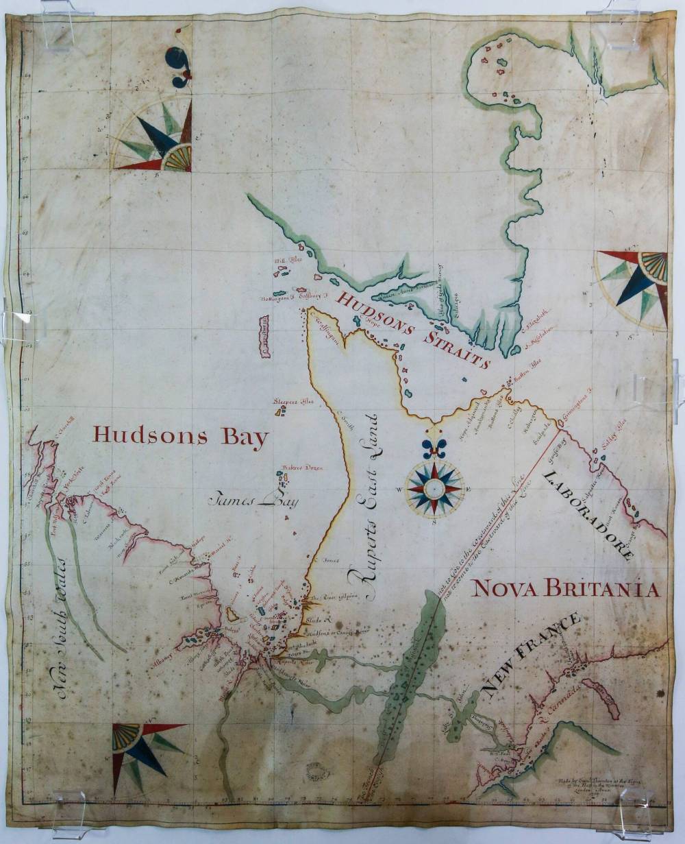
JOHN WOODS / FREE PRESS
A Hudson’s Bay map from 1709 in the Hudson’s Bay Archives collection.
“We have one copy of it and we have determined we have Selkirk’s copy,” Epp said.
In addition to the Hudson’s Bay Campany maps, there will be others on display. These include: a literary map of Winnipeg produced for the National Book Festival in the early 1980s showing locations written about in books, city maps of both Winnipeg and Brandon, and a map of the Winnipeg Electric Railway Company’s trolley system.
“We also have the largest map in the display — a Winnipeg map from 1905 measuring 150 cm by 183 cm (five by six feet),” she said.
“These are all places we know — we know the shape of the Assiniboine and Red. This will add layers to where we are.
“I hope people will be fascinated by it.”
kevin.rollason@freepress.mb.ca
Kevin Rollason is a general assignment reporter at the Free Press. He graduated from Western University with a Masters of Journalism in 1985 and worked at the Winnipeg Sun until 1988, when he joined the Free Press. He has served as the Free Press’s city hall and law courts reporter and has won several awards, including a National Newspaper Award. Read more about Kevin.
Every piece of reporting Kevin produces is reviewed by an editing team before it is posted online or published in print — part of the Free Press‘s tradition, since 1872, of producing reliable independent journalism. Read more about Free Press’s history and mandate, and learn how our newsroom operates.
Our newsroom depends on a growing audience of readers to power our journalism. If you are not a paid reader, please consider becoming a subscriber.
Our newsroom depends on its audience of readers to power our journalism. Thank you for your support.
Related Articles
Saving our history, before it’s too late WAG exhibition weaves ancestral, contemporary works to tell Manitoba Métis story
Advertisement Advertise With Us
Advertisement Advertise With Us
History
Updated on Tuesday, April 9, 2024 10:11 AM CDT: Corrects spelling of Clark