

Hurricane Ernesto: Nova Scotia and eastern Newfoundland told to watch for big waves
Advertisement
Read this article for free:
or
Already have an account? Log in here »
To continue reading, please subscribe:

Digital Subscription
One year of digital access for only $205*
- Enjoy unlimited reading on winnipegfreepress.com
- Read the E-Edition, our digital replica newspaper
- Access News Break, our award-winning app
- Play interactive puzzles
*First annual payment billed as $205.00 + GST for one year. This annual subscription will automatically renew at $233.00 + GST every 52 weeks (10% off the regular annual price of $259.35). Offer available to new and qualified returning subscribers only. Cancel any time.
To continue reading, please subscribe:
Add Free Press access to your Brandon Sun subscription for only an additional
$1 for the first 4 weeks*
- Enjoy unlimited reading on winnipegfreepress.com
- Read the E-Edition, our digital replica newspaper
- Access News Break, our award-winning app
- Play interactive puzzles
*Your next Brandon Sun subscription payment will increase by $1.00 and you will be charged $17.95 plus GST for four weeks. After four weeks, your payment will increase to $24.95 plus GST every four weeks.
Read unlimited articles for free today:
or
Already have an account? Log in here »
Hey there, time traveller!
This article was published 16/08/2024 (762 days ago), so information in it may no longer be current.
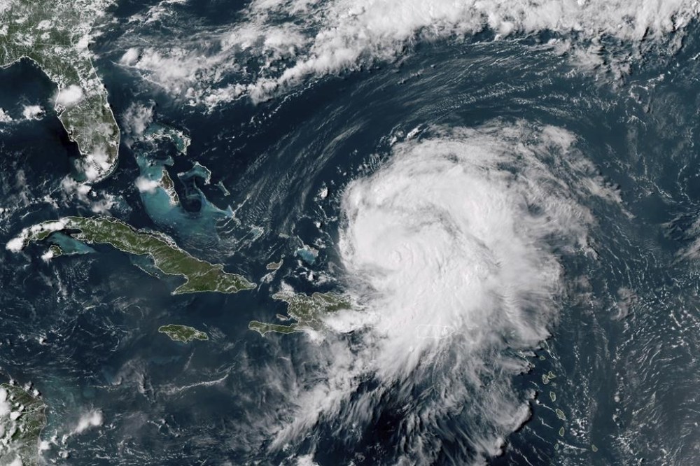
HALIFAX – Residents of Nova Scotia and eastern Newfoundland are being told to keep a close watch on the progress of Hurricane Ernesto as it churns its way northward, pushing big waves far from its swirling centre.
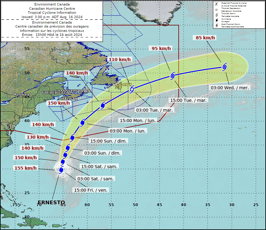
As of Friday, the storm was expected to stay far to the south and east of Nova Scotia, but the Canadian Hurricane Centre in Dartmouth, N.S., said Ernesto could cause some coastal flooding in parts of eastern Newfoundland by Monday night.
“There is some opportunity for strengthening in the next few days,” senior meteorologist Bob Robichaud told a news conference Friday. As well, he said the storm will pick up speed as it reaches colder Canadian waters on the weekend.
“As we’re going into this weekend, people should pay close attention to the evolution of this storm.”
Earlier in the day, the centre issued a statement saying the southwest-facing shorelines of eastern Newfoundland’s Burin and Avalon peninsulas will be lashed by large waves and a possible storm surge on Monday night.
“There could be some coastal impacts due to waves,” Robichaud said, adding that they could reach five to 10 metres in height.
But he stressed that the predicted track of the storm has its centre moving to the east of the heavily populated Avalon Peninsula, which is good news for the region that includes St. John’s.
“Even if the storm does make landfall in the eastern part of the Avalon Peninsula, the strongest winds are still expected to be offshore,” he said. “Given the current track, we might be escaping the worst-case scenario in terms of wind and rain.”
Ernesto was expected to generate significant ocean swells that will begin slamming into Nova Scotia’s Atlantic coast by late Saturday.
“Beachgoers and sightseers are encouraged to exercise caution,” the centre’s statement said, adding that the swells could cause hazardous surf and rip currents.
“Since the storm circulation will be quite broad with tropical air and downpours spreading well beyond its centre, Nova Scotia and Newfoundland could see at least some rain either directly or indirectly on Monday and Monday night.”
Meanwhile, mariners and others working farther offshore on the Grand Banks are also being advised to keep a close watch on the storm’s progress. Robichaud said it’s important to remember that the peak of hurricane season isn’t expected until next month.
“We’ve already seen some record-breaking storms this year, especially with Beryl back in June and July,” he said.
On July 11, the remnants of hurricane Beryl flooded parts of western and central Nova Scotia with more than 100 millimetres of rain in just a few hours. A 13-year-old boy in Wolfville, N.S., died when he was swept into an overflowing drainage ditch.
“Everything that we’re looking at still indicates that we’re going to see a very active hurricane season …. There’s a lot more to come as we head into the peak.”
Ernesto, the third hurricane of this year’s Atlantic hurricane season, was expected to reach Bermuda by Saturday.
On Friday, the tiny but wealthy British territory in the middle of the Atlantic was preparing to open shelters and close government offices.
As the storm closed in, it was churning out maximum sustained winds at 155 kilometres per hour. It was expected to dump between 150 and 300 mm of rain over the island, which has seen its share of hurricanes.
For a Category 2 hurricane, Ernesto is a large storm, with winds exceeding 120 km/h extending up to 110 kilometres from its centre.
Earlier this week, Ernesto battered the northeast Caribbean, where it left hundreds of thousands of people without power or water in Puerto Rico.
This report by The Canadian Press was first published Aug. 16, 2024.
— With files from The Associated Press